WELCOME TO OUR VIRTUAL OPEN HOUSE & ENGAGE PAGE
A virtual simulation of an Open House has been provided as an interactive experience where you can learn more information about the project and learn how your input was used during the first two phases of engagement to inform the recommendations. You can also learn how you can participate in our upcoming virtual events where you can learn about the recommendations for the North Central Mobility Study that we will be presenting to Green Line Committee later in the spring.
The image below is of an Open House, like what you would experience at an in-person event held at a community hall.
For a better user experience click on the arrows on the top right corner to expand to full screen mode. Within the image below is a series of information panels, with a flashing icon for you to click on, they have been numbered in order of how you should click. Once you click on the flashing icon this will open a pop-up box with more information which will include either;
- a video for you to watch, click on the play icon, this will pop-up in a larger box, once you are done watching press X, to close out and move to the next panel.
- a link for you to visit such as a PDF document or a website.

PROJECT OVERVIEW
With the addition of the Green Line LRT and North Central BRT, Calgarians are going to move differently throughout Calgary. This study is being conducted to understand how travel patterns may change as a result of Green Line operations and BRT services on opening day and into the future. Since October 2020, we have hosted virtual public engagement on this project to gather your input on how to improve mobility for all transportation users and how to protect community liveability in north central Calgary.
The feedback we have received over the last two phases of engagement from October 2020 to March 2021, was used by the project team to inform the recommendations for this study that will help shape the future of mobility in north central Calgary.
Now, during the “Inform” phase of engagement from April 15 to 22, 2021, short-,medium- and long-term recommendations from the study are presented. These recommendations will be presented to the Green Line Committee later in the spring. Next steps include developing implementation strategies. There is currently no funding allocated for the implementation of recommendations. Funding will be allocated following the City corporate infrastructure priorities process.
The study area extends from north of the Bow River to 160 Avenue N, east to Deerfoot Trail and west to Crowchild Trail, with a focus on communities bordering the LRT and BRT routes.
The goal is to understand what changes we need to make to our transportation network to support Green Line LRT and the BRT and to ensure safe and efficient movement for people walking, wheeling, driving or taking transit and for goods movement on opening day and into the future.
Crescent Heights Mobility
This study does not include the community of Crescent Heights; a separate study is being conducted for this area.
Learn more about the Crescent Heights Mobility Study
What is our approach?
The approach used for this study is a multimodal approach to understand how Green Line and BRT lanes can be supported in the network. The goals of this work are to improve overall mobility along Centre St N corridor and Harvest Hills Boulevard, protect community livability along the Transit corridor by reducing cut-through traffic and to improve safety and connections for all transportation users.
The outcomes of this study are:
- Proposed measures to improve walking and wheeling
- Proposed measures to reduce cut-thru traffic
- Proposed intersections for multi-modal enhancements
- Proposed locations to review for travel-time reliability for all transportation users and for connectivity to downtown
The outcomes of this study will support Green Line and BRT and will help provide safe and efficient travel experiences for all users of the network.
A thorough safety review of the pre-COVID-19 transportation network was done to identify locations for improvements. A traffic operational review was conducted to identify potential challenge areas and to identify where cut-through traffic can happen.
When Green Line eventually extends north, we will see a shift in the choice of travel for many residents in north central Calgary. During stage 1 of Green Line, the terminus station will be at 16 Avenue N. In order to continue to provide options for Calgarians to connect to downtown, we have analyzed the network with future traffic volumes and identified locations to improve for all transportation users.
PROJECT MAP
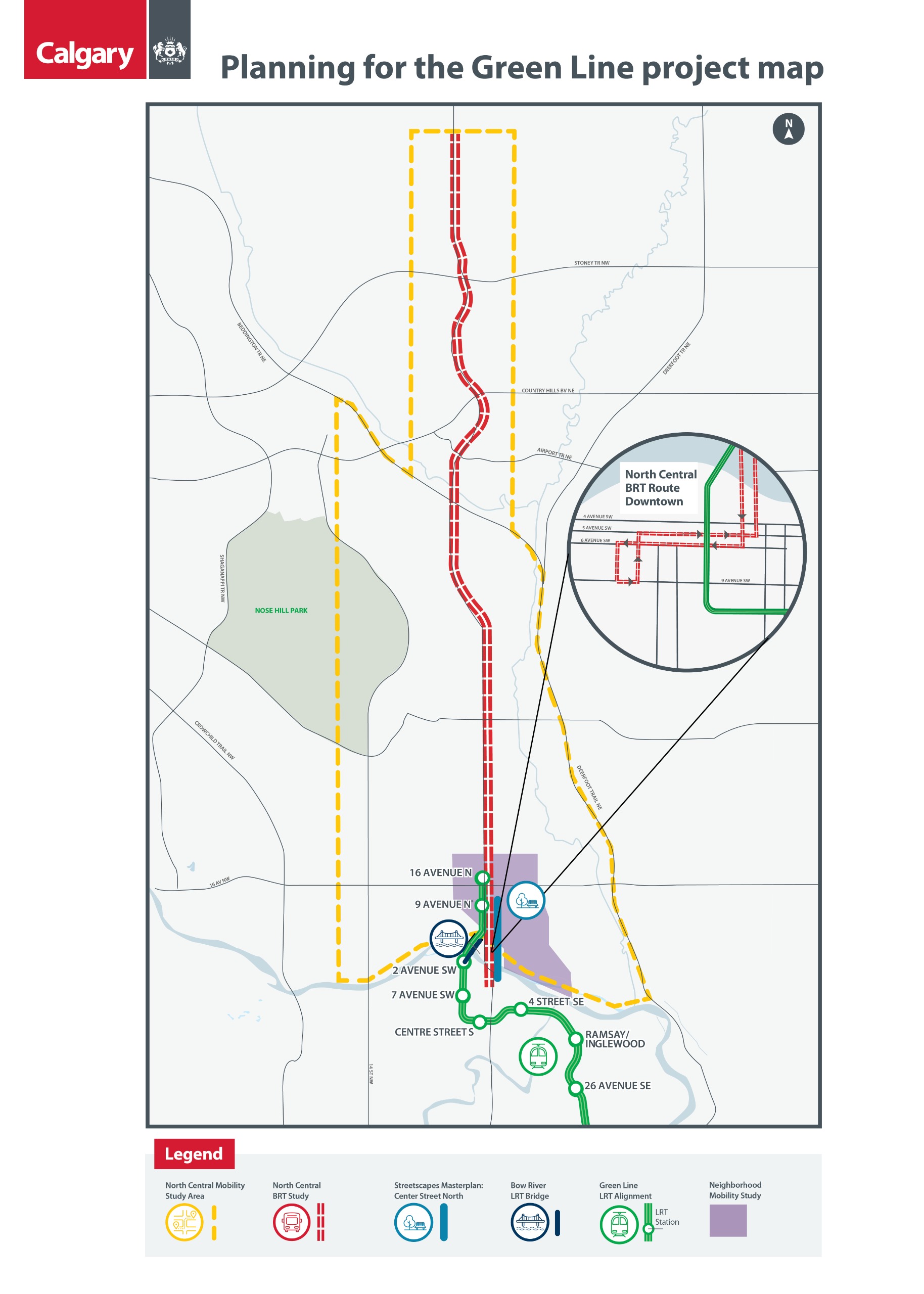
Project Study Area
To view this map in PDF, pleaseclick here.
PREVIOUS ENGAGEMENT
In January and March 2021, we conducted the second phase of online engagement for the North Central Mobility and BRT Studies, which included virtual drop-in open house events in the evening and during lunchtime and an opportunity to provide online feedback. During this phase of engagement, we learned that, even with the restrictions of COVID-19, Calgarians still want opportunities to provide input and stay informed as we move through the functional planning process.
The top themes that emerged from the public engagement process for the North Central Mobility Study in January and March 2021 were:
- Community is concerned about cut-through traffic on residential streets
- Commuters have concerns on congestion/delays to travel to and from downtown on parallel corridors
- Want improved:
- turning movements & signal timings at major intersections
- traffic flow through the adding or lengthening of turning lanes at intersections
- Enhance connections for walking and wheeling on main corridors to encourage active transportation modes
- Concerns over cost of mobility improvements to taxpayers
What We Heard Reports
- Phase 1; Envision (All Projects) What We Heard.
- Phase 2: North Central Mobility & BRT Studies What We Heard Report
- Final Engagement Summary (All Projects)
Public feedback was incorporated in the development of the short-medium- and long-term recommendations for the study.
FAQs
OUR FINDINGS
There will be a dispersion of traffic from Centre Street
Opening day of Green Line stage 1, it is estimated that during the rush hours over half of the vehicles currently using Centre Street N will be displaced to nearby corridors as identified below:
- Approximately 30-40% diverted to Edmonton Trail N.E.
- Approximately 30-40% diverted to Memorial Drive (east and west of Centre Street N.)
- Approximately 15-20% diverted to 14 Street N.W.
- Approximately 10% diverted to 10 Street N.W.

OUR RECOMMENDATIONS
During engagement held for the North Central Mobility Study from October 2020 – March 2021, we heard that the community is concerned about cut-through traffic on residential streets and about congestion/delays to travel to and from downtown on parallel corridors when Green Line and BRT services are open. Commuters in the study area also stated they want improved turning movements and signal timings at major intersections and improved traffic flow by adding or lengthening of turning lanes at intersections. Additionally, people traveling in the community expressed a desire for enhanced connections for walking and wheeling on main corridors.
This public feedback along with technical analysis has been used to develop short-, medium- and long-term recommendations for the study that we are sharing with you below. These recommendations outline changes we need to make to our transportation network to support Green Line LRT and the BRT and to ensure safe and efficient movement for all transportation users.
SHORT-TERM
SHORT-TERM RECOMMENDATIONS
- will be implemented in 0-5 years
- focused on improving mobility for people walking and wheeling as well as protecting community liveability with introducing traffic calming in north central Calgary
Traffic Calming Measures
We are recommending the following measures between 16 Avenue N & McKnight
Formalizing Temporary Traffic Calming Measures
- 2/3 Street N.W. Corridor
- 1 Street N.E. Corridor
Introduce New Traffic Calming Measures
- Greenview Drive N.E. Corridor
- 32 Avenue N Corridor
- 24 Avenue N Corridor
- 20 Avenue N Corridor

Walking & Wheeling Improvements
We are recommending the following enhancements between 16 Avenue & McKnight Blvd. N
Proposed Pedestrian Crossing Enhancement
- 4 Street at 18 Avenue N.W.
- Centre Street at 19, 21, 22, 26 & 30 Avenues N
- Edmonton Trail at 18, 23, 25, 27 Avenues N.E.
- 4 Street N.W at 32 Avenue & 36 Avenue
- Centre Street N at 34 Avenue & 38 Avenue
- Edmonton Trail N.E. at 38 Avenue & Greenview Drive
Build Sidewalk
- 24 Avenue between 4 & 5 Street N.W.
- 25 Avenue between 4 & 5 Street N.W.
- 26 Avenue between 4 & 5 Street N.W.
- 41 Avenue (32 Avenue Connector) between 1 & 6 Street N.E.
Install Neighbourhood Greenway Features
- 30 Avenue between 4 Street N.W and Edmonton Trail N.E.
- 36 Avenue between 4 & 3 Street N.W.
Build Shared Use Pathway
- Edmonton Trail between McKnight and 41 Avenue N.E.
- 40 Avenue between 4 Street N.W. & Centre Street N
- 4 Street N.W. between 40 & 36 Avenue N.W.
Upgrade Shared Use Pathway to Current Standards
- 4 Street N.W. between McKnight Blvd & 40 Avenue N.W.

MEDIUM & LONG-TERM
MEDIUM-TERM RECOMMENDATIONS
- will be implemented in 5-10 years
- recommendations include adding turn lanes and lengthening turn lanes in the locations below
- focused on improving congestion/delays to travel to and from downtown
The medium-term mobility recommendations are:
- Safety and operational improvements for all transportation users
- Corridor-wide review for multi-modal enhancements:
- Edmonton Trail N.E. (south of 16 Avenue N.E.) & 14 Street N.W.
- Add northbound and southbound right turn lanes at the intersection of 16 Avenue N.E. and Edmonton Trail N.E.
- Add a northbound right turn lane at the intersection of McKnight Boulevard N.E. and
Edmonton Trail N.E. - Add northbound and southbound left turn lanes at the intersection of Centre Street N. and
40 Avenue N.W. and 41 Avenue N.E. (part of BRT project) - Lengthen southbound left turn lane at intersection of Centre Street N. and 64 Avenue N. (part of BRT project)
- Monitor northbound left turn to determine if enhancements are required at Centre Street N. and Beddington Boulevard N. (part of BRT project)


LONG-TERM RECOMMENDATION
- will be implemented in 10+ years
Long term recommendation is to:
- Enhance connections along Memorial Drive N.E. between downtown and Deerfoot Trail
NEXT STEPS
The next steps for this study are:
- These recommendations will be presented to the Green Line Committee later in the spring.
- There is currently no funding allocated for the implementation of recommendations. We will need to identify funding for these recommendations. This Funding will be allocated following the City corporate infrastructure priorities process.
- We will then need to develop implementation strategies for the mobility plans.


