Project Overview
The Bow River LRT bridge will connect the Green Line LRT with Calgary’s north central and southeast communities. It will also provide a new opportunity for walking and wheeling from Eau Claire, Chinatown and the centre city to Crescent Heights.
At approximately 450m long, the Bow River LRT bridge will be one of Calgary’s longest bridges crossing the river valley. The Bow River bridge connects the 2 Street S.W. LRT station and Downtown underground tunnel with Centre Street N., where the LRT will operate on the surface of the roadway. The bridge crosses a variety of man-made and natural environment features. An important element in the planning is to ensure the bridge connects seamlessly with the existing pathway system in Crescent Heights and the future Eau Claire Promenade.
In June 2020, City Council approved the updated plan for the Green Line LRT. This new plan outlined the vision for an LRT bridge that crosses Prince’s Island Park and the Bow River. As part of Council’s approval of the updated Green Line plan, Green Line was directed to advance the next stage of planning for the Bow River bridge and report back with the Bridge Plan in spring 2021. Green Line is presenting this plan to committee in May.
As outlined in the Segment 2 Concept Report, the current stage of planning is focusing on:
- Refining the bridge alignment and configuration
- Determining if the pathway is situated on the top deck, bottom deck, or on the side of the bridge
- Seeking public input on bridge architecture objectives
- Developing a preferred bridge architectural concept
The Bridge Plan includes:
- The vision and outcomes for the Bow River LRT bridge
- The refined alignment (route) for the bridge, including the shape of the curve over Prince’s Island Park
- The preferred architectural form, including options for the main span over the Bow River
- Layout of the bridge’s multi-use pathway for pedestrians and cyclists
- Next steps for advancing the planning and design of the Bow River LRT bridge
In fall 2020, Green Line started a series of engagements to collect insights about the preferences of citizens and stakeholders to help plan the bridge. This input has been used to inform the current plan and will be used in future stages of planning. The final plan developed by Green Line will used by the construction contractor for the LRT to develop the final design and build the bridge. The What We Heard report for phase two of engagement for the Bow River LRT bridge is available here.
Planning and design objectives
Six overarching planning and design objectives were established in spring 2020 and included in the Green Line concept report that City Council approved in June 2020.
- Provide continued functionality and experience of the river pathway and Prince’s Island Park
- Minimize impacts to views
- Incorporate flexibility for thoughtful bridge architecture options
- Minimize environmental impacts
- Mitigate construction impact to users of Prince’s Island Park and the surrounding area
- Consider strengthened connectivity for people who walk and bike
Building on the six planning and design objectives, public and stakeholder engagement was used to develop design principles that will be used to further guide the planning and design of the Bow River LRT bridge.
- Sustainable transportation choices – the bridge will provide a safe, accessible and efficient transportation experience prioritizing LRT while accommodating pedestrians and other non-motorized wheel modes.
- Protecting view corridors – a low-profile bridge form will ensure that views along the river valley and skyline are maintained.
- Protecting the environment – the bridge form and its construction will respect and protect the natural environment along the Bow River and across Prince’s Island during construction and future LRT operation.
- Context sensitive form – the bridge form will complement its unique location, including how it crosses the Bow River, the history and character of the Centre Street bridge, Prince’s Island Park and the promenade, and surrounding landscapes.
- Accessible and connected – the new bridge will be safe and accessible to pedestrians and wheeled modes, providing a new connection for those travelling across the Bow River to get to where they live, work and play.
- Community pride – the new bridge will be a place for Calgarians to meet, to socialize and to celebrate their community.
Please click through each of the tabs below, to learn more about the Bow River LRT bridge plan.
Alignment
A conceptual alignment for the Bow River bridge was included in the Segment 2 Concept Plan presented to City Council in June 2020. This Plan acknowledged that alternatives to the bridge alignment across the river were still being explored and would be refined through the next phase of planning. Over the past year, planning for the bridge has advanced and the alignment has been refined. The bridge path will continue to be refined as the detailed engineering design for the bridge is completed.
The Bow River bridge connects the 2 Avenue LRT Station and downtown underground tunnel with Centre Street N., where the LRT will operate on the surface of the roadway. The bridge alignment is approximately 450m long and crosses a variety of built and natural environment features. In the south, the bridge landing interfaces with the soon-to-be-constructed Eau Claire Promenade before crossing over the Lagoon, Prince’s Island Park and the Bow River main channel. In the north end, the bridge crosses over the regional pathway, Memorial Drive and the west tip of Field of Crosses before landing on McHugh Bluffs, where the LRT will connect into Centre Street N. The height of the bridge increases across the alignment, where it sets out from the underground station at 2 Street, rises from a low elevation over Prince’s Island Park and lands at a higher elevation on McHugh Bluff. The location of bridge landings, landscape features and topography have all influenced the planning for the refined bridge alignment.

ALT TEXT: An example of the possible 'S' curve alignment over the Bow River, this graphic highlights specific areas of consideration for the bridge planning team, including: the Eau Claire Promenade, how the bridge crosses Prince's Island Park and the Bow River, the passing over Memorial Drive and the Field of Crosses to land at McHugh Bluff.
Over the past year, the alignment for the bridge was refined based on the updated design for the 2 Avenue station. As planning for this station progressed, its north end shifted approximately 10m to the west from its original location contemplated in the concept design. As a result, the location for the south end of the bridge shifted to match the 2 Avenue station, which influenced the ultimate shape and orientation of its alignment.
The bridge follows a diagonal path over Prince’s Island Park and the Bow River to connect the 2 Avenue station with Centre Street N. LRT operating requirements require the tracks to have gradual curves and run along gentle slopes to allow for the most efficient movement of the train. As such, the bridge alignment follows a gradual s-shape across the landscape, comprising of a general southern curve, a short straight section in the middle (crossing the Bow River), and another general curve to the north. The s-shape allowed the length of the bridge to be extended, which was needed to keep the bridge deck at a gentle slope, less than 5%, to satisfy both LRT operating and pathway accessibility requirements. As an added benefit, the s-shape allowed the alignment to be designed to generally follow the border between Prince’s Island Park’s parkland and constructed wetland. This provides an opportunity to minimize impacts to the constructed wetland and to positively reinforce the border between the park’s distinct landscape environments.
Form
The Segment 2 Concept Plan presented to City Council in June 2020 acknowledged that the next phase of planning would establish the preferred architectural concept for the Bow River bridge, including the design for the multi-use pathway that will be incorporated into the bridge. This section describes the architectural concept including general form, span structural form, multi-use pathway arrangement and Bow River main span crossing design.
General form
Given the length of this bridge, the structure will be a multi-span viaduct that uses a series of regularly spaced piers to carry the bridge’s structural load from 2 Avenue Station to Centre Street N.
The bridge is intended to be a simple, low-profile form that best preserves the area’s views and respects the surrounding natural and built environment. To accomplish this, the design minimizes the bridge’s thickness by using shorter spans that require a regular placement of piers.

Superstructure design
The next stage in the bridge planning process was to establish the superstructure design, which carries the weight of the LRT trains and pathway users. Two options were explored:
- Ride-over structure – a thin bridge deck with a deep structure below the deck, which creates clearance issues beneath the bridge (e.g. 4 Avenue C-Train bridge).
- Ride-through structure – a thick deck with a flat structure below the deck that reduces clearance issues beneath the bridge (e.g. Sunnyside C-Train bridge) .

ALT TEXT: The image shows current LRT bridge types in Calgary at 4 Avenue S.W. and Sunnyside. The comparison of the two structures involves the thin deck edge and deep structure of 4 Street with the thick deck edge and below LRT track deck of the Sunnyside bridge. This illustrates the decision process for placing the multi-use pathway for the Bow River LRT bridge beside the LRT rather than beneath it.
The ride-through structure was determined to be the best option for the following reasons:
- The bridge’s height at the south end is very low as it emerges from the 2 Avenue station and it will allow park users to freely move around the park under the bridge.
- The height of the bridge should not place structural elements at a height that would be impacted by flood waters during a 1 in 100-year flood event. The ride-through structure is best protected from flood events.
River crossing
While the multi-span viaduct structure, with its regular spacing of piers, will cross over the natural and mand-made obstacles on land, the width of the channel is too wide for the bridge to cross without placing at least one pier in the river. Given this condition, the planning process evaluated the preferred approach for crossing the river’s main channel.
Calgarians input was gathered through engagement in February 2021 to include in the evaluation of the bridge forms that would be selected to go forward to the next stage of planning.
The main features of each bridge form, along with images, are listed below:
Multi-span viaduct
- A low-profile design that does not stand out in the skyline.
- Continuous aesthetic and experience across the entire bridge.
- Requires a pier in the river, which could restrict river flow and impact recreational use of the river.
River span below deck (true arch)
- A low-profile design that does not stand out in the skyline.
- Continuous experience on the bridge and gateway experience on the Bow River.
- Clear span structure with reduced impacts on the river.
River span above deck (tied arch)
- A low-profile design over land with a character defining element over the river that adds visual interest to the skyline.
- A clear marker above the Bow River for viewers and bridge users.
- Clear span structure with minimal impacts on the
river.
Multi-span Viaduct. This form option is no longer being considered.

River Span Below Deck. This form is one of two options being carried forward to the next stages of design.
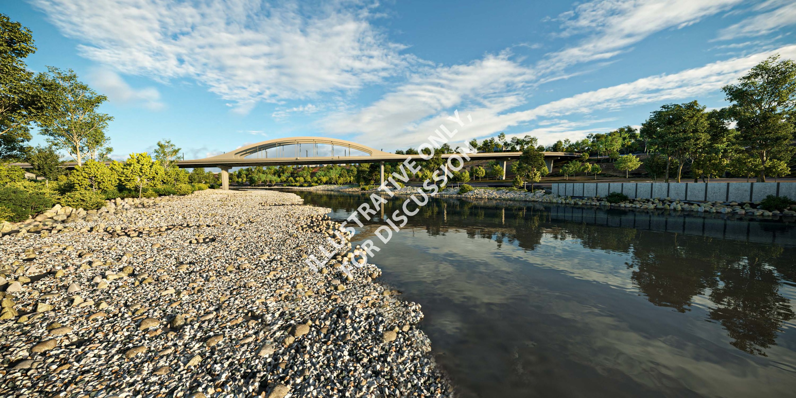
River Span Above Deck. This form is one of two options being carried forward to the next stages of design.

Evaluation and recommendation
Nearly 200 Calgarians provided input on their preferences and interests for the three Bow River main span forms. Given the low number of participants, the feedback received was not considered representative of the population but does indicate some general trends. Regardless, feedback indicated that the least preferred option was the multi-span viaduct with a pier in the river.
After evaluated the options against six evaluation themes and considering feedback from engagement, we determined that the multi-span viaduct option with the pier in the river had the highest environmental impact from construction, greatest construction and long-term safety risks and least stakeholder acceptance. Therefore, the viaduct option will no longer be considered for the Bow River main channel crossing.
Since there were no significant differentiators between the true arch (below deck) and tied arch (above deck) forms at this stage of planning, both forms will be carried forward into the next design stage.
Multi-Use Path
As planning for the bridge form advanced, an evaluation was undertaken to determine the preferred approach for integrating a multi-use pathway into the bridge. Three pathway arrangements were considered, which were evaluated against important project considerations that included:
- Pathway connections: is there the ability to connect the pathway with the Eau Claire Promenade, McHugh Bluff pathway and Centre Street N.
- Flood resiliency: does the pathway arrangement impact the bridge’s 1 in 100-year flood level design
- Prince’s Island Park headroom: does the pathway arrangement impact how users move around the park beneath the bridge
- Aesthetics: does the pathway arrangement compliment or impact the aesthetics of the bridge form
- Structural complexity and cost: does the pathway arrangement make the bridge structure more complicated and affect cost
The three options explored were:

Based on the evaluation, we selected the option of two multi-use
pathways on main bridge deck (beside LRT). In addition, from an aesthetic point
of view, this form will allow for a more open handrail design which helps hide
the bulkier structure and gives the bridge a lighter, thinner appearance.

Pathway experience & connections
Unlocking new views
The planned width of the multi-use pathways on the bridge, located on each side of the bridge, will be 3 to 4 metres. This width accommodates the anticipated volumes of pathway users—the volume of people using the bridge is expected to grow from 4,200 on opening day to about 7,000 by 2046.
During engagement, we shared renderings to help Calgarians imagine how they might experience the pathway and the new views the bridge will provide. They were asked what kinds of features or amenities they felt should be included to provide a safe and comfortable user experience. Respondents expressed a desire for the following safety features:
- physical separation from the LRT,
- well-lit areas,
- CCTV surveillance,
- non-slip surface,
- painted lines to separate pedestrian and wheeled users
Those engaged also suggested that the pathways be wide enough to incorporate viewing areas and benches for resting. All feedback received on the pathway amenities will be considered in future stages of bridge planning and design when design requirements for urban design features are established.
Below are rendering illustrating the views that will be unlocked by the new Bow River LRT bridge.


ALT TEXT FOR ABOVE IMAGES: These images show four viewpoints from the new Bow River LRT bridge from the downtown skyline and views to the Rockies, the view over Prince's Island Park and the Field of Crosses as well as the view to the Centre Street Bridge.
During engagement, many opinions were expressed about how to manage the pathway from a user perspective:
- Physically separate those walking and wheeling to avoid conflicts and improve user safety
- Retain flexibility to choose which side of the bridge they wish to travel on
- Divide each pathway to provide two-way pedestrian travel on the outside and one-way wheeling on the inside to accommodate pedestrians who might only journey mid-way across the bridge to enjoy the views
At this stage in bridge planning, no decision will be made on the future operations of the pathway. This decision will be made in the future once the bridge design is developed and the width of pathway have been finalized.
Connecting with Eau Claire and Crescent Heights
Eau Claire and the promenade
The bridge connects into the 2 Street S.W. LRT station, which will be an underground station as part of the Eau Claire Market redevelopment site. The location of the station requires the bridge to land directly onto the Eau Claire Promenade and Bow River pathway system. The promenade is used by nearly 10,000 users a day and connects people to Prince’s Island Park, Peace Bridge, Riverwalk, Eau Claire Plaza and the broader downtown core.
We explored many options for designing the pathway connections between the Eau Claire Promenade and bridge to create one continuous and enjoyable experience for Calgarians. These options included:
- Shifting the 2 Street S.W. LRT station further south
- Shifting the LRT route and bridge landing north into Prince’s Island Parks lagoon area
- Lowering the height of the promenade under the bridge
- Rerouting the promenade up-and-over the LRT alignment at the point where it becomes a tunnel (LRT portal)
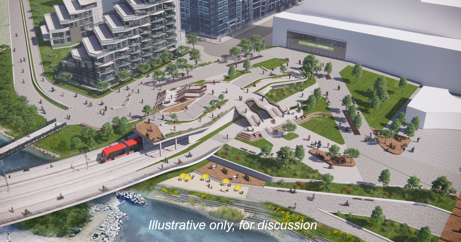
The first three options were not recommended as they did not meet LRT operating requirements, impacted flood resiliency or were not aligned with pathway design guidelines. The up-and-over option (see image below) was deemed technically feasible. A proof of concept design (to verify the concept is practical) was developed to confirm if this option could meet the pathway experience requirements and the following objectives:
- Provide a strong east/west river pathway experience
- Accommodate all modes (walk, wheel), abilities and anticipated volumes (~10,000 daily)
- Connect 2 Avenue station and Bow Bridge pathway with Promenade, Eau Claire Plaza and Prince’s Island Park
- Provide adequate rest areas along the route
- Make the area a destination, not a detour
Birds eye view. The design allows those on wheel to travel under and around, while those on foot also have the option to travel up and over.
View from the East of the illustrative concept for Eau Claire.
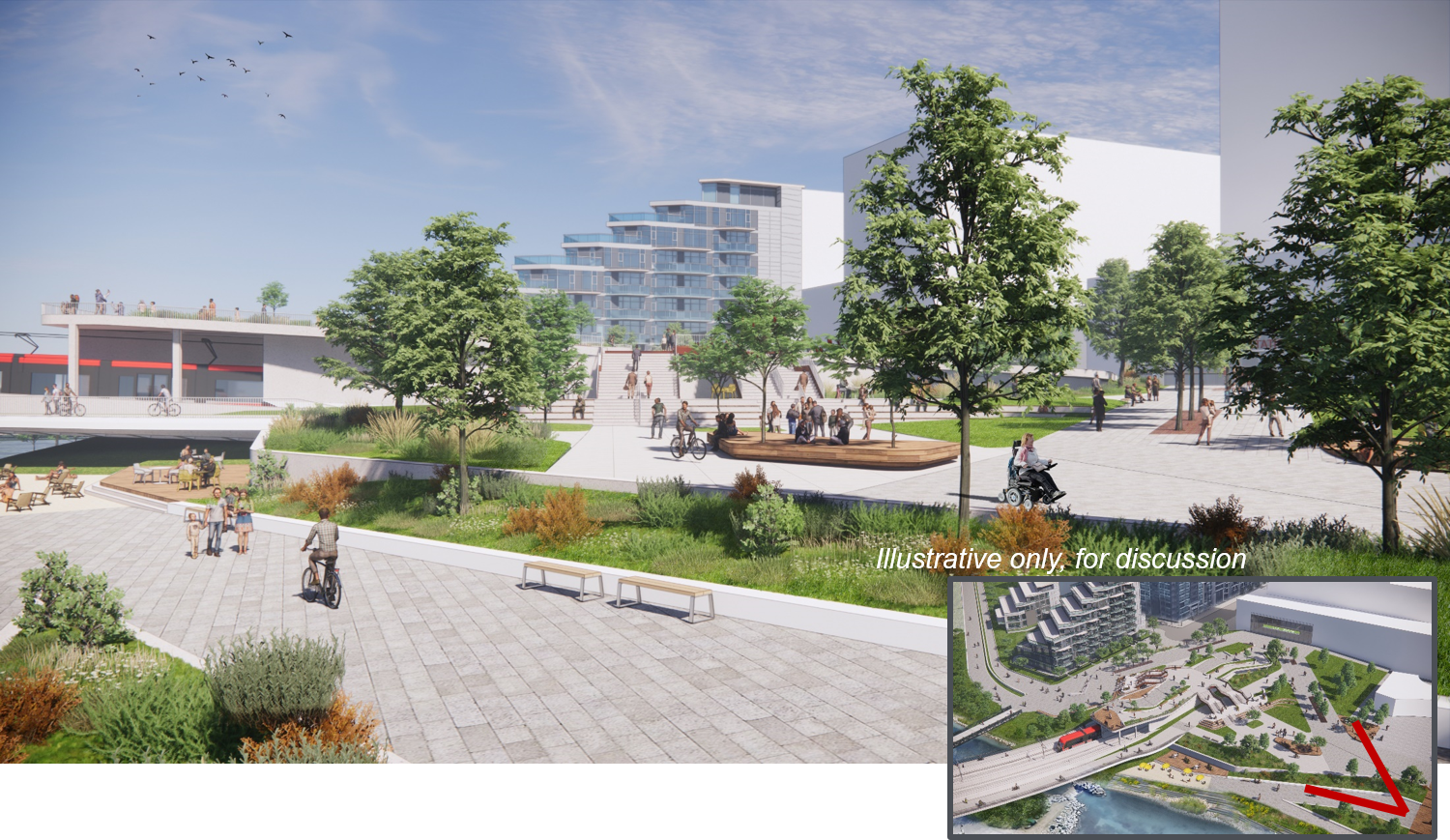
View from 2 Street north of the illustrative concept for Eau Claire.

View from existing 2 Street bridge to the south.

View from 2 Street station entrance, facing northwest.

View from portal roof to staircases and overlook. Views to Prince's Island Park and the new bridge are seen in the background.

Low, oblique view of overlook, bridge pathway, promenade and beach.

Crescent Heights & McHugh Bluff
In Crescent Heights, the new Bow River LRT bridge will land on McHugh Bluffs. As illustrated in the conceptual rendering to the left, the bridge’s pathways will connect with:
- Centre Street N. and the east-west pedestrian crossing at Samis Road
- The existing McHugh Bluffs pathway that connects with Crescent Road
Future planning stages for the bridge will include detailed design to reconfigure the existing pathway for the connection.


Next Steps
Additional work is required to advance the planning and design of the Bow River LRT bridge prior to procurement and construction. Key next steps include:
- Reporting back to Green Line committee in May 2021 on the Bridge Plan
- Initiating the Reference Concept Design
- Advance the engineering and design of the bridge form and main span options
- Advance the multi-use pathway design including widths, modal separation and user experience, as well as connections to the north and south, and features including lighting, non-slip surfaces, and benches
- Establish the technical, urban design and visual performance requirements for the bridge components
- Confirm procurement and construction timelines
- Continuing to communicate with stakeholders and the public—additional opportunities for engagement with the public will be explored
Archive: 2021 Virtual Open House
For our engagement earlier in 2021, a virtual simulation of an Open House was provided as an interactive experience where participants could learn more information about the projects in Crescent Heights and learn how to participate. You are welcome to review the information for a high-level overview of the projects.
The image below is of an Open House, similar to what you would experience at an in-person event held at a community hall.
For a better user experience click on the arrows on the top right corner to expand to full screen mode. Within the image below is a series of information panels, with a flashing icon for you to click on, they have been numbered in order of how you should click. Once you click on the flashing icon this will open a pop-up box with more information which will include either;
- a video for you to watch, click on the play icon, this will pop-up in a larger box, once you are done watching press X, to close out and move to the next panel.
- a link for you to visit such as a PDF document or a website.
Once you have finished reviewing the information, please scroll below to provide your feedback on the project pages.

For a plain text transcript of the video links included above, please click here.


