WELCOME TO OUR VIRTUAL OPEN HOUSE & ENGAGE PAGE
A virtual simulation of an Open House has been provided as an interactive experience where you can learn more information about the project and learn how your input was used during the first two phases of engagement to inform the recommendations. You can also learn how you can participate in our upcoming virtual events where you can learn about the recommendations for the North Central BRT Study that we will be presenting to Green Line Committee later in the spring.
The image below is of an Open House, similar to what you would experience at an in-person event held at a community hall.
For a better user experience click on the arrows on the top right corner to expand to full screen mode. Within the image below is a series of information panels, with a flashing icon for you to click on, they have been numbered in order of how you should click. Once you click on the flashing icon this will open a pop-up box with more information which will include either;
- a video for you to watch, click on the play icon, this will pop-up in a larger box, once you are done watching press X, to close out and move to the next panel.
- a link for you to visit such as a PDF document or a website.
Once you have finished reviewing the information, please scroll below to learn more.

PROJECT OVERVIEW
As Green Line leaves downtown and crosses the Bow River to 16 Avenue N in the first stage of construction, we know that communities to the north must connect to the transit network and that bus service will need to adapt to the new LRT line. The study will consider improvements from downtown along the existing Centre Street N and Harvest Hills Boulevard route to 160 Avenue N. Through our engagement we will be looking to:
- Examine the best locations for stations to provide access to key destinations in your community
- Learn how you currently use and access transit service in your community
- Explore your BRT service priorities and desires for amenity improvements
Improvements will benefit transit customers by providing a more direct, reliable service and customer experience by upgrading the existing BRT route up Centre Street N to a MAX BRT. Calgary Transit customers have consistently told us that reliability, safety, value for money/quality and convenience are some of the most important aspects of their transit trip. MAX BRT provides customers with:
- Convenience – fewer stops, signal priority, queue jumps, dedicated lanes, next bus arrival time displays
- Travel time and reliability – use of transit priority infrastructure gets customers to destinations faster and more reliably
- Comfort and safety – enhanced lighting, heated shelters, larger platforms
- Connections – access to more major destinations, and fewer transfers to get to final destinations
Public Engagement
As part of Green Line’s segment 2 functional planning, the project team completed an integrated communications and engagement program that provided citizens the opportunity to participate in meaningful engagement. We ensured coordination across all of the active projects as part of our segment 2 functional planning, including the North Central BRT Study.
Engagement and communications occurred for segment 2 projects from October 2020 through to April 2021 over two phases of engagement and one phase of information sharing. Throughout the project we engaged with residents and Calgarians at-large, Community Associations, Business Improvement Areas, local business owners, special interest groups and ward offices.
To review our engagement in more detail, please read the What We Heard reports below.
What We Heard Reports
PROJECT MAP
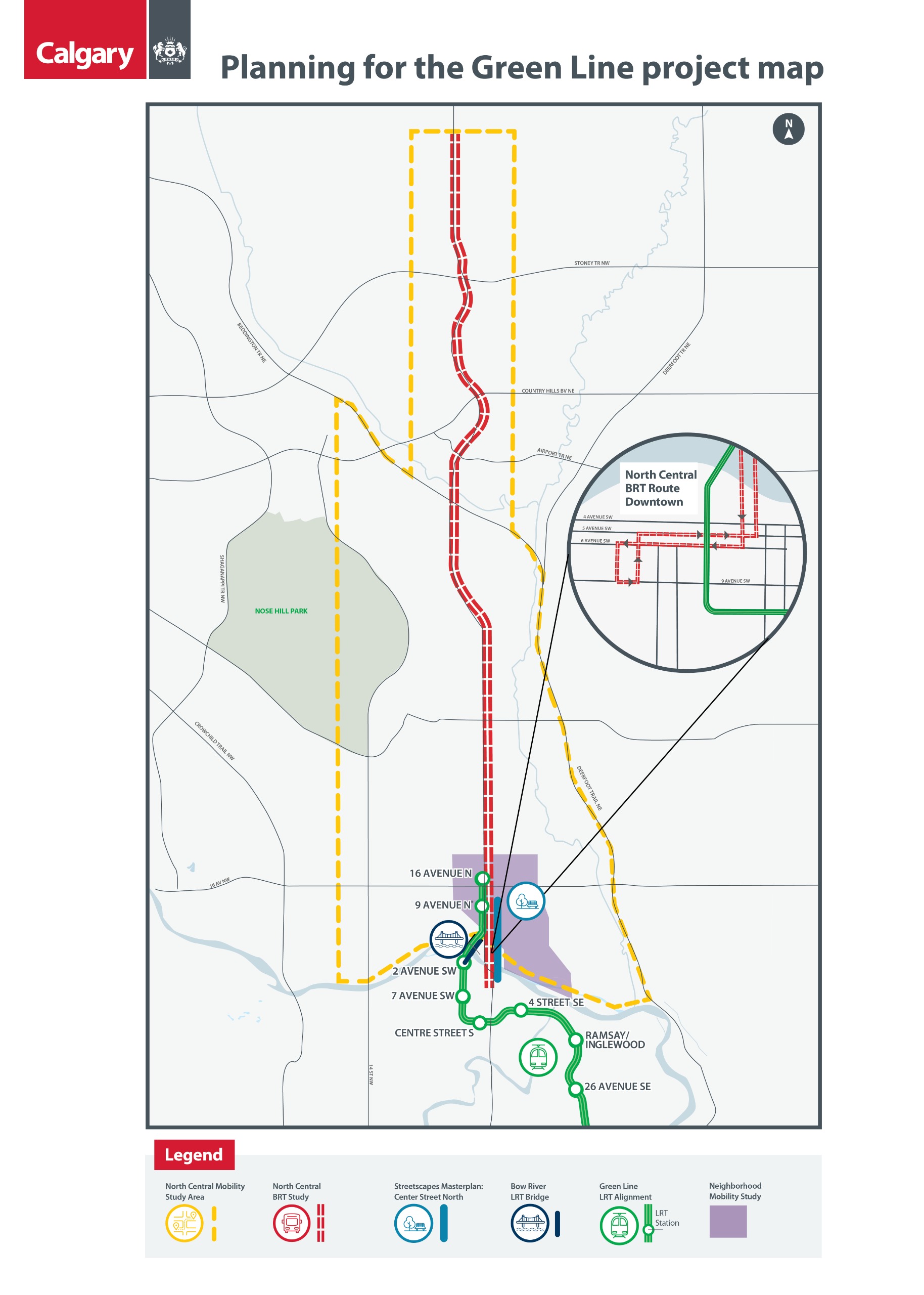
Project Study Area
To view this map in PDF, please click here.
BACKGROUND INFO
The Green Line LRT is the largest infrastructure project in Calgary's history. With $4.9 billion in unprecedented investments from the Government of Canada, Government of Alberta and City of Calgary, the Green Line LRT will play a key role in shaping our city's future. The Green Line LRT will kick-start our economy creating 20,000 jobs, connecting people and places, and reducing congestion on our roads, building the Calgary of tomorrow.
High-quality transit, like the Green Line LRT, is a necessity for cities to support sustainable growth, attract investment and create jobs. This critical piece of our transit network will connect more communities to downtown and various other destinations, with ridership projected at 60,000 trips per day.
After significant engagement with the provincial government following the provincial review of the Green Line LRT project, The City made the decision to pause the segment 1 procurement schedule in December 2020, to provide time to conclude discussions with the province.
This pause does not impact the work that is currently underway, including establishing the Green Line Board, progressing enabling works to make way for construction and functional planning for segment 2 (16 Avenue North to 4 Street S.E.), including the Streetscape Masterplan for Centre Street North, North Mobility Studies, North Central Bus Rapid Transit (BRT) study and the Bow River bridge. The Light Rail Vehicle (LRV) and construction management contracts for segment 2 are also underway
In the meantime, there is a significant amount of work underway, including establishing the Green Line LRT Board and progressing enabling works (related projects like utility relocations, land preparation and environmental remediation) to make way for construction. We're also continuing with the functional planning process launched in fall 2020, which includes the below Planning for the Green Line projects:
- Streetscape Masterplan for Centre Street North
- Crescent Heights Mobility Study
- North Central Mobility Study
- North Central Bus Rapid Transit (BRT) Study
- the Bow River and Elbow River LRT bridges
FAQs
FAQ
PROPOSED BRT IMPROVEMENTS
The first phase of Green Line Light Rail Transit (LRT) will extend to 16 Avenue N. The proposed improvements will link the investments that The City is making with Green Line to provide improved connections to north central communities and support the future transition to LRT along the corridor.
During engagement held from October 2020 – March 2021, we heard a desire for more reliable bus service, interest in reducing congestion for transit vehicles and cars, and the need to balance providing on-street parking and accommodating traffic during peak travel hours. This feedback along with technical analysis has been used to further develop the opportunities identified for the North Central BRT into short-, medium- and long-term improvements, shared below. These proposed improvements will:- provide shorter transit travel times
- increase reliability
- enhance comfort and convenience
- improve accessibility
- improve walking and wheeling amenities
Short-term improvements:
- Can be implemented in 0 – 5 years
- Quick and immediate improvements to the current services
- Focus on pedestrian accessibility and operational improvements
These include:
- Downtown Bus-only lanes
- On 5 and 6 Avenues S.W. from Centre Street S to 6 Street S.W.
- Pedestrian and wheeling improvements
- Various locations along the corridor
- Intersection improvements
- Extend left turns (Harvest Hills Blvd./96 Ave. N & Centre St./64 Ave. N)
- 78 Ave N.E. Bus Terminal
- Bus priority improvements
- Centre St. to Beddington Blvd. ramp
Medium-term improvements:
- Can be implemented in 5 – 10 years
- Improvements will be timed with Green Line LRT opening
These include:
- Pre-build Future Green Line Park and Ride lot
- 96 Ave./Harvest Hills Blvd. N.E.
- Stations upgraded to MAX standard
- Peak hour transit-only lanes
- Centre St. from 16 Ave. N. to McKnight Blvd. N.
- North Pointe Park and Ride operational improvements
- Centre Street South Public Realm & Streetscape improvements
- BRT infrastructure integration at 4 Ave./Centre St. S.
Long-term improvements:
- Implement in 10+ years
- Long-term improvements would be triggered based on increased transit ridership, increased traffic and congestion, and demand for route extension
These include:
- Extend BRT service north to 160 Ave N.
- New MAX stations
- Transit-only lane additions
Image 1 of 10


