Westbrook Communities Local Area Plan
The Westbrook Communities Local Area Plan has now concluded. For the most up-to-date information. Please click the link below.
Westbrook Communities Local Area Plan Approved by Council
On April 25, 2023, Council approved the Westbrook Communities Local Area Plan with a 12-2 vote. View the Council-approved Plan here.
The Westbrook Communities Local Area Plan (the Plan) is the result of over three years of engagement with participants including youth, seniors, residents, business owners, community association and development industry representatives, and a dedicated and diverse working group. Feedback provided by participants throughout the process helped shape and refine the Plan that was brought forward to Council.
The Westbrook Communities Local Area Plan sets out the vision and policies to guide growth, change and investment in the communities of Wildwood, Spruce Cliff, Westgate, Rosscarrock, Shaganappi, Glendale, Killarney/ Glengarry, Glenbrook and the portions of Upper Scarboro/Sunalta West and Richmond that are west of Crowchild Trail. In addition to policies directing how land can be used and redevelopment in the area, the Plan identifies actions that can be taken to support communities as they experience growth and change.
With the approval of the Westbrook Communities Local Area Plan, there is now direction in place to support the evolution of the area over the next 30 years—providing direction on future development and investment that residents, landowners, builders/developers, City Planners and Councillors can commonly refer to when new development and investment ideas are proposed. The Plan supports revitalization of Westbrook Station, enhanced mobility options, increased housing choice, enhanced local parks and open spaces and the addition of local commercial amenities.
Thank you to everyone who dedicated their time and provided input throughout the creation of the Westbrook Communities Local Area Plan!
Plan Overview
Key Ideas
Westbrook Station is the focal point of the Westbrook Communities Local Area Plan. It is an important commercial area, the key transit station and the place where the 17 Avenue and 37 Street Main Streets meet.
We heard from residents that the area is underutilized and not living up to its full potential. By improving the public space around the station area, encouraging high- density mixed-use development and improving walking and cycling connections to the station, the full potential of the area can start to be realized.
We have simplified and streamlined the development direction for the area, providing more flexibility for development to occur while ensuring the objectives of creating an active, safe and high-quality urban centre are met.
We heard there was a desire to make cycling and walking safer and more convenient. Improving the way residents, workers and visitors get in and around the Westbrook Communities is a key focus for the Plan. Focusing cycling and walking improvements in and around transit stations, main streets and key corridors (such as 26 Avenue SW, Spruce Drive and 45 Street SW), as well as near schools and along regional pathways, will have the greatest impact on improving safety, connectivity and convenience for everyone.
We also heard that improving engineered walkways (sometimes called catwalks – which are found in the communities of Spruce Cliff, Wildwood, Westgate, Glendale and Glenbrook), will help community mobility, safety and beauty. Improving paving, lighting and pedestrian crossings around these walkways as well as improving the interface of new development with the walkways will make these connections safer and more convenient for neighbourhood residents.
Focusing growth around transit stations means more people will have transit as a safe and convenient option to get around. Finally, improving vehicle mobility for all users through better street design will increase safety for drivers, cyclists and pedestrians.
Population change is a key issue in the Westbrook Communities. People have different desires and needs when finding a home, whether it is the location, price, size, style, amenities or outdoor space. Increasing housing variety and choice is key to helping people stay in the area as they age or their needs change, as well as to help attract new families to the area. Housing variety and choice helps a community’s population stabilize and grow, while restricting housing to only single-detached homes limits options for people and results in population declines – particularly among youth.
We heard a wide range of opinions on providing housing choice, from those who wish to see all types of small-scale housing throughout all communities, to those who want to protect neighbourhoods exactly as they are today. A balanced approach was taken – allowing single and semi-detached homes throughout the area, while focusing rowhouses and townhouses in key areas (such as transit stations, around larger parks and on corner lots).
Providing additional housing choices means that populations in the Westbrook Communities can stabilize and help support local schools, amenities and businesses. The Westbrook Communities Local Area Plan balances the need for more housing choice with concerns about change in neighbourhoods by focusing growth around transit stations, main streets and activity centres, while allowing for gradual change throughout communities.
Learn more about what was considered as the limited-scale policy direction was created.
INCREASING HOUSING CHOICE - Key Considerations for Limited-Scale Policy Direction

As the Westbrook Communities grow and change, parks and open spaces need to change with them. We heard that amenities such as skating rinks, playgrounds, splash parks, seating and public art, among others, are things that people want to see more of in their parks and open spaces. Improving amenities at parks and open spaces within the area will provide activities that cater to a greater diversity of recreational, cultural and social needs for all seasons.
New homes adjacent to parks and open spaces will enhance the interface with the park space, and development adjacent to key open spaces, such as Killarney Park, will allow for people to grab a coffee or perhaps an ice cream, and enjoy it in the park. Improving access to and within parks is also a key component of the Plan. Better pathways, lighting and accessibility in parks means that more people can enjoy parks more frequently.
We heard that local shops and businesses are important to residents and input on the best locations for new local businesses and commercial amenities was shared.
The Westbrook Communities Local Area Plan allows for a concentration of commercial amenities along key corridors such as 17 Avenue SW or in key nodes such as Westbrook Station and Richmond Centre. The Plan also allows more flexibility in providing locally focused commercial amenities, such as corner stores and cafes along key corridors within neighbourhoods, such as 45 Street SW, 33 Street SW and 26 Avenue SW. Based on public feedback, local commercial options were removed from most local parks, as well as corridors such as 30 Avenue SW.
Having more commercial amenities in close proximity means that more people can meet their daily needs within a short walk, bike or drive. More commercial amenities nearby not only provides convenient access for residents, it also means less cars on the road, as people don’t have to drive as far, or at all, to meet their daily needs.
Urban Form & Building Scale Maps
The Urban Form & Building Scale Maps help visualize where and how growth and change could happen in the plan area over the next 30 years and beyond.
The Urban Form and Building Scale Maps are intended to be interpreted together.
- The Urban Form Map details the purpose and general function of different parts of the communities, such as residential, commercial or mixed.
- The Building Scale Map outlines the general height and massing of buildings.
Additional details on the categories within these maps can be found in section 2.2 and 2.3 of the Westbrook Communities Local Area Plan.
It's important to remember that change is very gradual and the Local Area Plan itself does not rezone land. It is property/landowners who determine if and when to propose to rezone their land.
A local area plan sets the vision for the evolution of the area—providing direction on future development and investment that residents, landowners, builders / developers, City Planners and Councillors can commonly refer to as new development and investment ideas are proposed.


Engagement Overview
Together, over a three-year period with thousands of participants, a local area plan for the Westbrook Communities was created.
From fall 2019 – fall 2022, conversations about where, why and how revitalization and redevelopment should happen took place with a range of participants. Thousands of individuals were involved in the creation of the Plan from youth to seniors, residents and business owners, community association and development industry representatives and a dedicated and diverse working group that provided in-depth insights and feedback throughout.

What We Heard & What We Did
Key Themes Heard & What We Did Summary Report
A summary of key themes heard through the project with a description of how each theme was considered or addressed.
WHAT WE HEARD REPORTS
- Phase 1.1 What We Heard Report [Fall 2019 - Fall 2020]
- Phase 1.2 What We Heard Report [Fall 2021 - Winter 2022]
- Phase 2 What We Heard Report [Winter - Spring 2022]
- Phase 3 What We Heard Report [Spring - Summer 2022]
KEY CONSIDERATIONS

FAQs
Engagement on small-scale homes took place in phase three, EXPLORE, in June 2022. The feedback provided in this phase of engagement was used to further refine the policy direction on where small-scale 3+ unit homes could be welcomed.
When the Westbrook Communities Local Area Plan was with shared with the public on October 25, 2022, it included the policy direction (page 30 of the Plan) that further refined the general direction provided through application of the Neighborhood Local and Limited Scale categories found within the key maps (Map 3: Urban From on page 21 & Map 4: Building Scale on page 22 of the Plan). This additional policy direction was created in response to participant feedback received in June 2022 and is summarized below:
- Single-detached and semi-detached homes supported throughout the area.
- Three or more unit homes (i.e. rowhouse, townhouse) supported on parcels with lanes that are:
- Within transit station areas (mapped within the Plan)
- Along a Main Street or separated by a lane from a Main Street (Main Streets mapped in Plan)
- On corner parcels
- Adjacent to parks and open spaces that are larger than 0.4 hectares
Including further detailed and nuanced policy direction (summarized above) helps provide additional direction and clarity about where different types of small-scale homes would be supported – helping respond to participant feedback. This policy direction further refines the general direction outlined in the Limited Scale category (found on Map 4: Building Scale) and the Neighbourhood Local category (found on Map 3: Urban Form). Without this additional and more refined policy direction, the application of the Neighbourhood Local and Limited Scale categories (the lowest intensity categories available) would indicate support all forms of small-scale homes (single-detached home, semi-detached home, rowhouses/townhomes) everywhere within those areas.
Prior to the final Plan being shared, members of the working group and community association representatives indicated that it would be helpful to show the Neighbourhood Local, Limited-Scale direction (summarized above) in a visual format. When the Plan was shared with the public on October 25, 2022, a Limited-Scale Map was shared as a supporting illustrative tool to help represent and clearly show the policy direction for small-scale homes in Limited Scale areas in a visual way. You can see the Limited Scale Map, along with additional information about key considerations, here: INCREASING HOUSING CHOICE - Key Considerations for Limited-Scale Policy Direction.
Growth and change happens in a community with or without a Local Area Plan. Market forces, consumer demand and other factors will drive change in the community. However, in areas with high demand that do not have a Local Area Plan, developers will often have to undertake site-by-site rezoning applications in order to build developments to meet demand for new housing and businesses.
This site-by-site approach can create uncertainty for local residents, who don’t know where the next application will come and what it will propose. It also creates uncertainty for developers, who don’t know for certain what types of proposals will be acceptable where. Without a local area plan, conversations about growth and change happen application by application, often in a manner disconnected from a wider vision.
A local area plan helps create more certainty for everyone by outlining the general expectation for what scale and type of new development is appropriate where and what policies will help shape development that is proposed.
A local area plan sets the vision for the evolution of the area over the next 30 years—providing direction on future development and investment that residents, landowners, builders/developers, City Planners and Councillors can commonly refer to as new development and investment ideas are proposed.
A local area plan includes the following key sections:
- Visualizing growth – What is the vision for the area? (vision and core values)
- Enabling growth – What type of growth makes sense where and what local/custom direction is needed to realize great development in this area? (future growth concept and development policies)
- Supporting growth – If growth occurs, what physical and social investments are needed? (future investment goals and implementation options)
A local area plan is a statutory document, adopted by Council as an Area Redevelopment Plan.
Input provided by citizens and other participants helped the project team understand perspectives, opinions and concerns throughout the all phases of the project. Input collected in each phase of the project helped influence and inform the concepts and policies that were created and refined throughout the process. Throughout the project, the project team shared what was heard, highlighted the key themes raised, and provided responses for how key themes were addressed and considered.
- Check out the "Engagement Overview" tab on the REALIZE page for more detailed information.
Public input provided in each phase of the engagement process was compiled, reviewed and considered as each chapter of the local area plan was created. 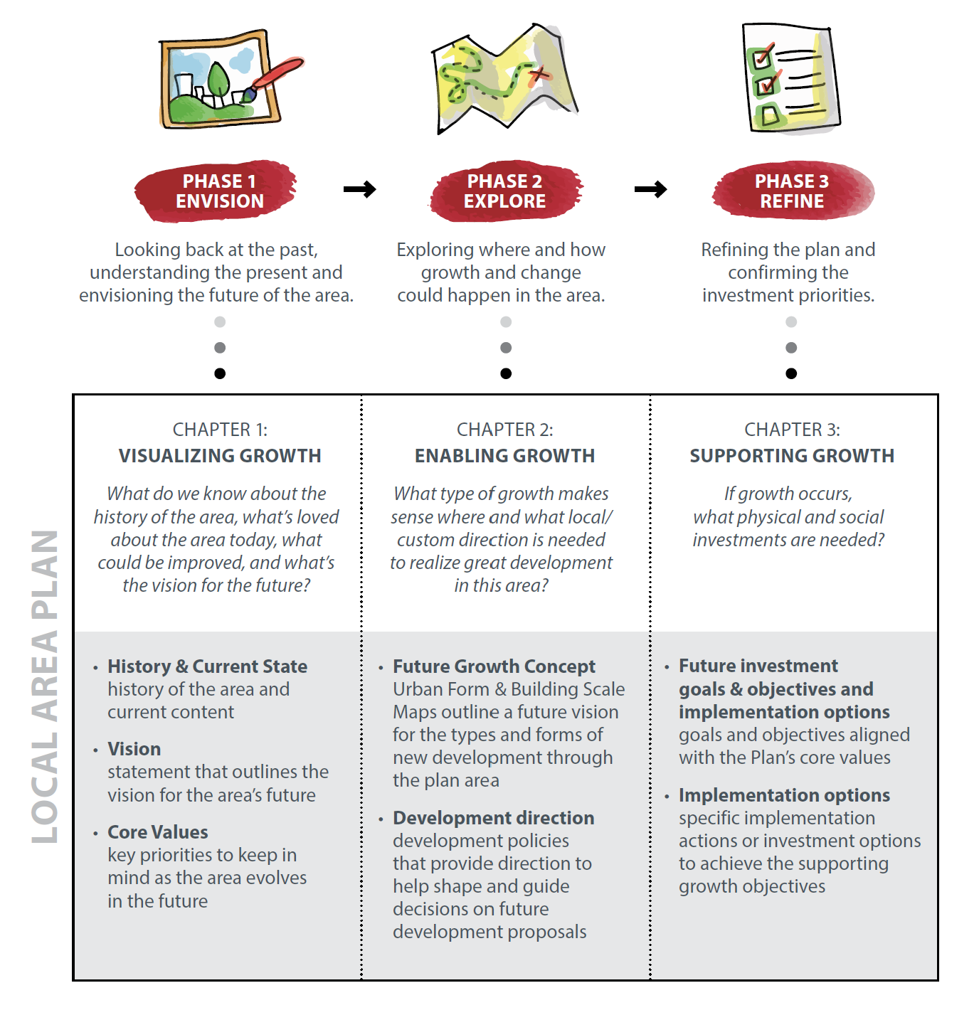
A variety of opportunities for involvement were available through the process that aimed to accommodate a range of participation interests and intensities, as well as to remove barriers to participation.
Engagement opportunities and methods included: Westbrook Communities Working Group sessions, in-person and virtual engagement sessions (with the public, community associations & development industry representatives), pop-up engagement events, online engagement, mailed engagement packages, My Idea Stations, Conversation Starter Kits and community walk & talks (with community association representatives).
Through the project, over 2.1 million advertisements were displayed to help raise awareness of the project and opportunities to get involved. Methods used to raise awareness included: mailed information, community newsletter articles and ads, large format road signs, social media ads (Facebook, Twitter, Instagram, Nextdoor), digital ads (including video ads on YouTube and audio ads on Spotify), digital and print ads in local restaurants, Communications Toolits for area Councillors and Community Association representatives to help spread the word.
Over 31 public engagement events, 23 community association sessions, 12 working group sessions, and 8 builder/development industry sessions were held. Online engagement was open for 152 days and over 44K engagement packages/booklets were mailed to residents and businesses. Overall, there were over 3,600 unique instances of direct engagement and over 9,000 comments were shared.
There are opportunities for the public to get involved at both the Infrastructure and Planning Committee (IPC) and Council public hearings.
The Plan is planned to be presented to the Infrastructure and Planning Committee (IPC) on December 8.
The agenda for both meetings will be posted a few days prior to the hearings at the link below:
Council and Committee Agendas, Minutes and Video (calgary.ca)
Those wishing to participate in the public hearings can submit their comments or register to speak. Comments submitted before the agenda has been posted should clearly state that the submission is for "The Westbrook Communities Local Area Plan".
Public Submission to City Clerks (calgary.ca)
Members of the public may also watch the Committee and Council hearings via live webcast:
Council and Committee webcasts (calgary.ca)
For more information visit Participate in a Council or Committee meeting (calgary.ca)
City Council is the decision maker for all statutory City planning policies. The Westbrook Communities Local Area Plan (the Plan) will be brought forward to the public hearing of Council for review and decision (date to be determined). Prior to the public hearing of Council, Infrastructure and Planning Committee (IPC) will review proposed Westbrook Communities Local Area Plan. The Plan is planned to be presented to the Infrastructure and Planning Committee (IPC) on December 8.
Following Council review and decision, the Calgary Metropolitan Regional Growth Board will review the Plan, prior to formal adoption by City Council.
Existing statutory and non-statutory policies (such as Area Redevelopment Plans (ARPs), Design briefs etc. will be rescinded or amended where appropriate. Administration’s recommendations for the Westbrook Communities Local Area Plan includes rescinding three and amending one existing statutory planning policies. The policies to be rescinded are: the Westbrook Village Area Redevelopment Plan, the Killarney/Glengarry Redevelopment Plan and the Shaganappi Point Area Redevelopment Plan. The Richmond Area Redevelopment Plan will be amended to remove those portions of Richmond that are within the Westbrook Communities Local Area Plan from the Richmond Area Redevelopment Plan.
Local area plans are meant to be living documents that may be amended and updated over time as the community changes and evolves and as conditions and circumstances in the area change.
City Council is the decision maker for all local area plan amendments.
No. The Local Area Plan itself does not rezone land. Property/landowners determine if and when to propose to rezone their land. If a land use rezoning (redesignation) were brought forward by a property/landowner, it would be reviewed for alignment with the Westbrook Hill Communities Local Area Plan, if the Local Area Plan is approved by Council. The Local Area Plan provides direction that would inform and guide decisions about development in the area.
The City of Calgary may propose to redesignate (rezone) land, and does so periodically in connection with initiatives such as the Main Streets program or if/when the Land Use Bylaw is updated. The process to update the Land Use Bylaw and redesignate parcels will include opportunities for public involvement and notification.
City Council makes the final decision on land use zoning applications. Administration must review all rezoning proposals and makes a recommendation to Council based on planning merits, supporting policy and comments received. Council refers to the Local Area Plan and other City policy and holds a public hearing prior to making a decision. Council can make a decision based on their own interpretation of policies, site characteristics and the merits of the application.
New development must always go through the proper permitting and approval process. For proposed development that conforms to existing zoning, developers must submit development permit applications, which detail the design (building height, size, materials, parking, landscaping, etc.) of the proposed development prior to proceeding with construction. The public can view the details of proposed developments, including plans, and can submit comments on proposed developments through the Development Map application (Development Map (PDMAP) (calgary.ca)). Affected parties can also appeal the approval of a discretionary development to the Subdivision and Development Appeal Board. Some types of developments, called permitted uses, such as contextual single-detached dwellings and contextual semi-detached dwellings, are not subject to public comment, are approved by the development authority after a technical review and are not subject to appeal as long as they follow all the rules of the bylaw.
If a proposed development does not conform to the existing zoning, and a developer wishes to bring the zoning in line with the Local Area Plan, the developer must submit a land use redesignation (rezoning) application. This process is also open to public comment, and similarly to development permits, information is posted on the Development Map application (Development Map (PDMAP) (calgary.ca)). The decision on a land use redesignation (rezoning) application is made by City Council, and a public hearing is held prior to the decision.
Three-storey homes are already allowed to be built in every community. As long as a home is within the height and lot coverage allowed, it can be approved by The City. Some communities are already seeing older bungalows being torn down and replaced with three-storey homes, and this is allowed throughout the city. 525 new single-detached homes have been built in the Westbrook Communities in the last 20 years, often replacing smaller bungalows with larger new homes.
No. Semi-detached homes and duplexes have the same allowable height and lot coverage as single-detached homes. Allowing semi-detached homes and duplexes doesn’t increase the allowable size of new homes, but it does allow two homes (plus suites) in a single building instead of one (plus suites).
Those details are not in the scope of the Local Area Plan; however, at the development permit stage details such as building design, site constraints, landscaping, parking, utilities and waste and recycling staging areas are discussed and carefully looked at. Privacy is also discussed as part of the design of the new development. For example, glass blocks or frosted glass can be placed when side windows are proposed. All discretionary development permits include the opportunity for the public to provide comments during the review of the proposal as well as to appeal the decision about a proposed discretionary development.
Currently, the Land Use Bylaw permits small-scale homes including single-detached homes to be built up to three storeys; however, specific design details are looked at during the development permit stage. The proposed development should align with the contextual rules set in the Land Use Bylaw. In addition, during the development permit application review, the file manager reviews comments from the public and discusses options with the applicant to better integrate the new proposed development into the existing context.
No. Neither the Land Use Bylaw nor the Local Area Plan regulate the materials or architectural design of homes. The Bylaw does regulate built form, which includes things such as lot coverage, building height and landscaping requirements, but the architectural style of a home is up to each individual homebuilder and owner.
As we have refined the plan and finalized the urban form category and scale modifier maps, our colleagues model potential growth scenarios based on the plan to understand how the population of the area can change over time. This model is then used by our transportation and water resources departments to analyze infrastructure capacity and usage based on potential population growth. This analysis will help identify potential upgrades that may be needed as growth occurs in the plan area. This information is also shared with other utility partners, such as Enmax, so they can similarly forecast growth and infrastructure capacity and plan for upgrades.
Frequently Asked Questions
Next Steps
LEARN MORE - Attend a Virtual or In-person Information Session
Attend a virtual or in-person session to learn more about the Westbrook Communities Local Area Plan and have your questions answered.
VIRTUAL Information Sessions
- Wednesday, November 2 from 7-8:30 p.m.
- Wednesday, November 9 from 6:30-8 p.m.
REGISTRATION REQUIRED. SIGN UP HERE for the session of your choice.
IN-PERSON Information Session
- Monday, Nov 7 from 6-8:30 p.m. at the Wildflower Arts Centre - 3363 Spruce Drive S.W.
REGISTRATION IS NOT REQUIRED for this session. Drop in anytime between 6 - 8:30pm.
SHARE YOUR THOUGHTS with Committee and/or Council
There are opportunities for the public to get involved at both the Infrastructure and Planning Committee (IPC) and Council public hearings. Members of the public can submit written comments to Committee and Council and/or can register to speak at both hearings.
The Plan is planned to be presented to the Infrastructure and Planning Committee (IPC) on December 8.
The agenda for both meetings will be posted a few days prior to the hearings at the link below:
Council and Committee Agendas, Minutes and Video (calgary.ca)
Those wishing to participate in the public hearings can submit their comments or register to speak. Comments submitted before the agenda has been posted should clearly state that the submission is for "The Westbrook Communities Local Area Plan".
Public Submission to City Clerks (calgary.ca)
Members of the public may also watch the Committee and Council hearings via live webcast:
Council and Committee webcasts (calgary.ca)
For more information visit Participate in a Council or Committee meeting (calgary.ca)
ENGAGEMENT FEEDBACK
Did you participate in the Westbrook Communities Local Area Planning process? We'd love to hear about your experience and ways that we can improve in the future. Please ensure your feedback is respectful.


