Phase 3 Introduction
The City of Calgary is updating development regulations in flood risk areas – Share your feedback today!
Making careful decisions about how we plan, protect, develop and build in the floodplain is a fundamental part of protecting and enhancing resilient river communities.
Thanks to critical investments in flood mitigation, Calgary’s flood damage potential of a 1:100 flood has been reduced by 70 per cent. Although this means our city is more flood resilient than ever, our river communities remain vulnerable to varying degrees of flooding. Development regulations in flood hazard areas remain essential to ensure safety and address residual risks, including groundwater impacts during river floods. Through the Calgary River Valleys Project (CRVP), we’re working to update Calgary’s Land Use Bylaw to reflect updated floodplain mapping and regulations.
This third stage of public engagement as part of the Calgary River Valleys Project (CRVP) is focused on presenting draft updated regulatory floodplain mapping and regulations for public feedback. This includes:
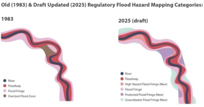
- Flood Hazard Areas: In May 2025, the Government of Alberta released updated Flood Hazard Area maps for communities across the province, including Calgary. The updated Flood Hazard Area maps reflect the latest understanding of a 1:100 flood. The province has adopted a new approach to flood hazard area mapping. This approach divides the flood hazard area into four categories (two of which are new) that reflect the level of risk of overland flooding. The City has developed draft proposed regulations aligned to this new mapping.
- River-flood related Groundwater Flood Areas: The City completed a groundwater study to deepen our understanding of Calgary’s river flood-induced groundwater risk. The study mapped groundwater levels during a 1 in 100-year flood event. The City is proposing to incorporate this into Calgary’s regulatory flood map as a new Groundwater Flood Fringe.
The draft regulations are intended to:
- Align planning and development with flood protection investments.
- Address both overland and groundwater river flood risks.
- Enhance safety in high-risk areas, especially for basement living spaces.
- Help buildings recover from more severe floods as our climate changes.
Click the below tabs for more information on how we got to phase 3.
Regulatory Flood Hazard Mapping & the Land Use Bylaw
The Land Use Bylaw is a collection of regulations that direct the use of land and the size and shape of buildings. Every property in the city is subject to a land use district that describes these conditions.
The Land Use Bylaw also contains overlay maps that add additional rules to certain areas. Overlays account for local conditions relating to things like industrial offsets, airport noise, and natural risks.
Calgary’s Regulatory Flood Maps form one overlay in Calgary’s Land Use Bylaw, and identify risk areas with associated land use and building regulations that help keep people safe and protect their properties from floods.
With new provincial flood hazard area mapping and city-led river-flood induced groundwater mapping now available, The City is working to update the Regulatory Flood Map through an update to the Land Use Bylaw.
The proposed Regulatory Flood Maps incorporate both Provincial Flood Hazard Area mapping, as well as City river-flood induced groundwater mapping. It would include the following areas:
- Floodway
- High Hazard Flood Fringe
- Flood Fringe
- Protected Flood Fringe
- Groundwater Flood Fringe
How do I complete the survey?
There are two surveys to complete as part of this engagement. You are welcome to complete either or both surveys.
- Survey 1 presents information about provincial Flood Hazard Area mapping, including describing the new hazard areas, showcasing the maps by reach of the river, and presents proposed regulations for each hazard area. Complete this survey to provide your feedback on proposed flood hazard area regulations.
- Survey 2 presents information about The City’s new Groundwater Flood Fringe. It describes what river-related groundwater flooding is, presents the Groundwater Flood Fringe mapping, and presents proposed regulations for this new zone. Complete this survey to provide your feedback on the proposed Groundwater Flood Fringe, and draft proposed regulations.
How do I know if I am in a Flood Hazard Area or the Groundwater Flood Fringe?
We have developed a draft online interactive version of Calgary’s proposed Regulatory Flood Map for the purposes of this engagement. You can see the extent of each area city wide and zoom in to your property to determine which hazard area applies to you.
Click here to view the draft online Regulatory Flood Map.
By clicking into each Survey, you will find a wealth of information about each hazard area, including mapping, proposed regulations, and opportunities to provide your feedback.
Additional background information / FAQs
Calgary's Regulatory Flood Map & the Land Use Bylaw
Flood Hazard Area Mapping
Groundwater Flood Fringe
Climate & Planning
Key dates
Tuesday, November 25, 2025 05:00 p.m. to 08:00 p.m.
Public Drop-In Session
Drop-in and provide your feedback for Stage 3 engagement engagement at Parkhill Community Association (4013 Stanley Road SW).
Thursday, November 27, 2025 05:00 p.m. to Tuesday, February 27, 2024 08:00 p.m.
Public Drop-In Session
Drop-in and provide your feedback for Stage 3 engagement at Riverbend Community Association (19 Rivervalley Drive SE).
Saturday, November 29, 2025 12:00 p.m. to 03:00 p.m.
Public Drop-In Session
Drop-in and provide your feedback for Stage 3 engagement at Montgomery Community Association (5003 16 Ave NW).
Monday, December 01, 2025 06:00 p.m. to 08:00 p.m.
Virtual Information Session 1
Calgary River Valley Stage 3 engagement virtual drop in session.
Note: This event may be cancelled if registered attendance is too low


