Phase 3: EVALUATE
PHASE THREE: EVALUATE HIGHLIGHTS
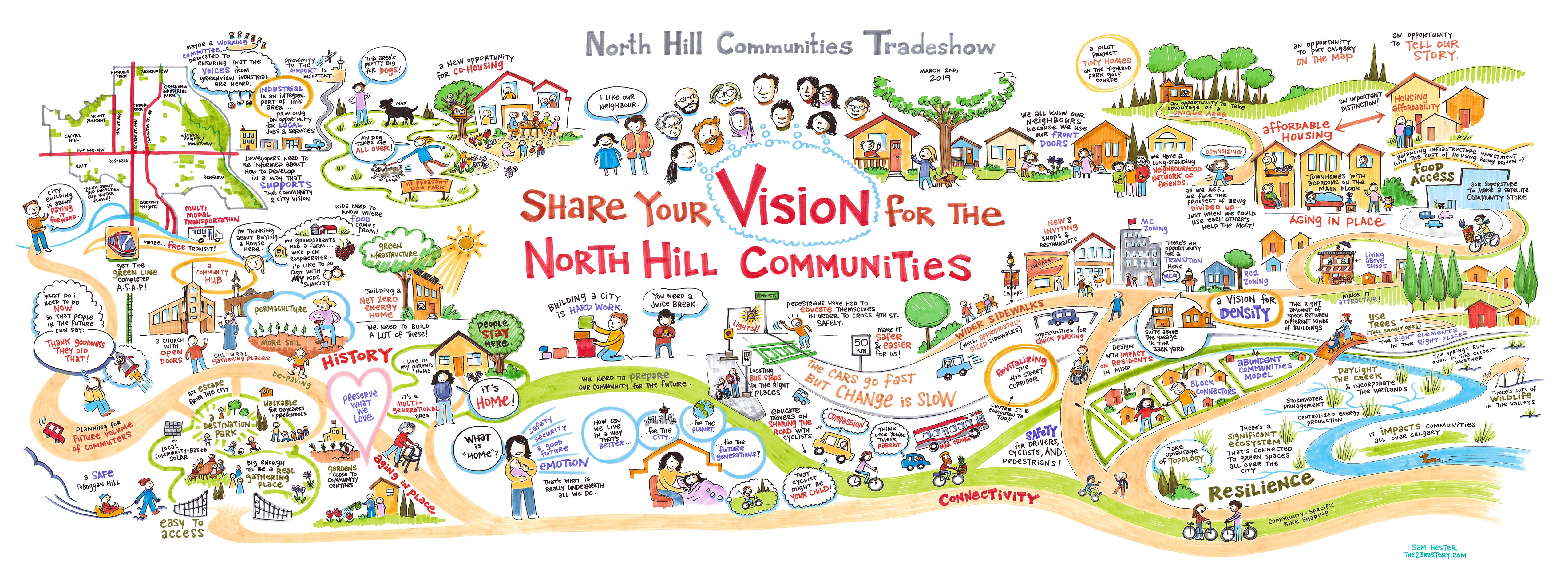
In Phase 3 [EVALUATE] we shared the draft local area plan and gathered feedback that will be used to help evaluate and refine the final proposed plan.
The draft North Hill Communities Local Area Plan has been informed by the proposed Guidebook for Great Communities. To learn more about the Guidebook, please click here. To review the draft plan, please content see below.
As part of engagement for phase three we:
- Held 13 in-person engagement events; including two open houses, three targeted workshops, two community association board member sessions, youth engagement, two summer pop-ups and three working group sessions.
- Collected feedback online from November 25 through December 8.
- Over 3,950 participants were involved online or in-person.
To review the detailed What We Heard Report and Engagement summary from phase three, click here. To stay connected on project updates, ensure you subscribe to the project email list.
To review the information panels from the in-person sessions, please click here (1 of 2) and click here (2 of 2). Content from the information panels has also been broken out in the tabs below.
LEARN MORE
Haven't had a chance to review the previous project details yet? Please ensure that you return to the PROJECT MAIN PAGE or the DISCOVER PAGE to get up-to-speed on what we have been up to over the past year.
PARTICIPATION
Below is a breakdown of participation throughout the phase three
AWARE 100,000+
The number of people who were made aware of the project and opportunity to get involved. Tools used to build awareness included: Facebook, Twitter, bold signs and informational displays, mailed postcards, and email updates.
INVOLVED 3,950+
The number of people who actively or passively got involved in some way. This includes people who visited the website, attended an event, subscribed for email updates, attended a working group session, etc.
CONTRIBUTIONS 2,700+
The number of pieces on input received through engagement This includes feedback received online, at events and through the working group sessions.
ENGAGED 900+
The number of unique individual contributors. Includes people who provided input online or in person.
How did people learn about phase three?
- 16 large format signs placed throughout the communities and at high-traffic intersections.
- Community Association posts, website updates, news articles
- Councillor Ward email updates (Ward 4, 7, & 9)
- Mailed postcards
- Paid social media advertisement campaign on Facebook and Twitter
- Email newsletter campaign through North Hill subscriber list
DEMOGRAPHICS (participation by community)
| Capitol Hill | 5% |
| Crescent Heights | 12% |
| Mount Pleasant | 35% |
| Tuxedo Park | 10% |
| Winston Heights-Mountview | 12% |
| Highland Park | 10% |
| Thorncliffe-Greenview | 2% |
| Renfrew | 10% |
| Rosedale | 2% |
| Other | 2% |
KEY THEMES
Overall, there was a high level of interest in the project, and a wide range of input was received from the community. The high-level themes that emerged throughout all of the comments received in phase three include:
- Citizens made suggestions to revise the vision and guiding principles to recognize the uniqueness of the North Hill Communities.
- Citizens made suggestions to revise the history section of the draft plan to better reflect the unique history of this area including references to important historic elements in the communities.
- Citizens shared general agreement with the placement of urban form categories, focusing on main streets and major corridors, but some comments suggested a more nodal land, less linear land, use concept.
- Citizens shared a desire to include policies that help mitigate the impact of higher scale development on lower scale development such as along 8th, 12th, and 20th Avenues N.
- Citizens made a number of suggestions to help us define supporting growth objectives and implementation options that would help achieve the plan objectives.
- Citizens value a walkable and accessible community and want to see enhancements to pedestrian and cycling infrastructure.
- Citizens expressed concerns over increased traffic and parking needs with higher density.
For more detail on What We Heard, please review the Evaluate What We Heard Report.
WHAT WE DID
The input collected in this phase of engagement is being used to update the final proposed plan. Input received through engagement will be one of many factors considered as the proposed concepts and supporting policies are refined. Other considerations include: City policies, technical and feasibility studies, market conditions, and previous engagement results.
Some key high-level changes that will be made to the final proposed plan include:
- revising the vision and core ideas to include more local specific information and be more future focused
- updating the urban form and scale maps
- additional development policies related to shadowing, transition and public realm
- chapter 3: implementation options revised and added in response to stakeholder feedback
- additional images and figures to be added and improved legibility of the maps.
The final proposed plan and the final engagement summary will be shared with the community prior to the plan being presented to the Special Policy Committee on Planning & Urban Development on March 4 and the public hearing of Council on April 6
WHAT?
What is a Local Area Plan?
A local area plan identifies and guides where and how future growth and development should happen within a specific area. It is a statutory document that will be adopted by Council.
A local area plan includes these components:
- VISUALIZING GROWTH - What type of growth makes sense where? (vision & maps)
- ENABLING GROWTH - What local/custom direction is needed to realize great redevelopments in this area? (development policies)
- SUPPORTING GROWTH - If growth occurs, what physical and social investments are needed? (future infrastructure & amenity goals)
A new local area plan will fill gaps in communities where no local plan currently exists and will replace other plans that are largely outdated.
What guides growth and redevelopment?
Local area plans are one of many strategic tools in our planning system that work together to create great communities for everyone. The tools in our planning system are used to achieve desired outcomes as planning moves from vision to outcome.

WHY?
Why is a Local Area Plan needed?
Local area plans provide guidance and direction as communities reach their natural redevelopment lifecycle stage and outline how communities can continue to evolve to meet people’s needs and remain places that people love and want to live.
THE LIFE CYCLE OF A NEIGHBOURHOOD
A big part of a community’s life cycle is redevelopment, which often begins when communities reach a certain age and homes, buildings and amenities need to be refreshed and revitalized or renewed and replaced.
COMMUNITIES MUST EVOLVE TO MEET PEOPLE’S CHANGING NEEDS AND PREFERENCES
People’s needs and preferences have changed over the past 50 years and they will continue to change over the next 50 years.
Census data shows that, today, proportionally fewer households are composed of a ‘two parent and kids’ family and more people are living alone, as part of a couple without children, or as part of a multigenerational family. One-person households accounted for 28.2% of all households in 2016, the highest share since 1867.
Nationally, one-person households became the most common type of household for the first time in 2016, surpassing couples with children, which were down from 31.5% of all households in 2001 to 26.5% in 2016. In comparison, the percentage of one-person households was 25.7% in 2001. Since 1951, the percentage of households comprised of just one person increased steadily, from 7.4% to 28.2% in 2016.
In the neighbourhoods of the North Hill Communities the overall population is below the peak and the occupancy rate, number of persons in a home, is lowering and the variety of housing forms is changing. Current 2018 population is 49,317, not much below the peak total, but different communities vary significantly. 2018 average occupancy rate (all housing forms) 2.16 person / unit.
The changing household composition will affect the demand for different types of housing forms, especially as housing affordability becomes an issue.
For more information on the changing housing preferences and needs in the North Hill Communities, click here.
WHERE?
Where is growth and redevelopment encouraged?
Growth and redevelopment in established neighbourhoods helps ensure population levels can be maintained. A key ingredient of thriving communities with vibrant local shops, amenities and schools is having the local population needed to support them.
Calgary’s Municipal Development Plan encourages future population and job growth in specific areas of the city. These areas include Activity Centres, Main Streets, and Transit-Oriented Development areas which are intended to support higher density development, more diverse forms of housing, retail and commercial services, public and essential services, as well as amenities. These areas are also characterized by frequent and high-quality light rail and/or bus transit service.
To the meet the goals and objectives of the Municipal Development Plan and to maximize opportunities for people to choose to live and work in the established areas, growth must also occur outside of these specific areas, within our communities. This allows for a greater range of housing types to suit all ages, lifestyles and housing needs in a way that contributes to communities evolving overtime
The draft plan focuses the highest intensity of future growth in and around the area’s Main Streets, future station areas, and activity centres.
TRANSIT ORIENTED DEVELOPMENT
Transit-Oriented Development (TOD) areas are generally defined by a 600 metre radius around a transit station which represents an approximately 5-8 minute walking distance.
MAIN STREETS
Main Streets are great places to live, work or visit because a range of amenities, shops, restaurants are accessible in one stretch via a range of transportation options.
NEIGHBOURHOOD ACTIVITY CENTRES
Neighbourhood Activity Centres (NACs) are often located in the middle of a residential area and provide locals with access to local shops and amenities, often within walking distance.
ESTABLISHED AREAS
Redevelopment in these areas is a gradual process that occurs over a number of years and is guided not only by planning policy but also by market demand and people’s changing lifestyle preference and housing needs.
Within the North Hill Communities there are four Main Streets (16 Avenue, 4 Street NW, Edmonton Trail NE and Centre Street N), three future Green Line transit stations (16 Ave, 28 Ave and 40 Ave), the MAX Orange BRT on 16 Avenue, a number of Neighbourhood Activity Centres such as the cluster of facilities and schools around the Renfrew Aquatic and Recreation Centre and existing strip mall and commercial development at 10 Street NW and 20 Avenue NW and an important employment hub in the Greenview Industrial Area.
HOW?
How is a local area plan implemented?
Private building / investment
It is largely individual landowners and property owners who help implement the plan if/when they decide to build something new on their parcel.
When land owners decide to build something new, they will have to submit an application to the city for consideration. Applications could consist of land use redesignations or development permits for consideration.
Through the application review process, any infrastructure required to support the individual project (such as utility connections and sidewalk repair/replacement) is identified and paid for the developer. The local area plan will guide the review of future applications.
Public building / investment
Established areas continuously change and evolve. This change in communities, including changes in job and population levels, impacts the desired and required provision of publicly funded amenities and programs.
- Project are generally considered and prioritized by City Administration and Council through The City’s business plans and budgets.
- Citizen direction on needs and desires informs City of Calgary evaluations of required public infrastructure investment.
Through our public engagement process, public investment goals for the area as well as specific associated implementation options have been identified. City service lines will use the identified implementations options as input to inform future budget requests.
How was this local area plan created?
The City works together with local residents, landowners, businesses, builders/developers and other interested stakeholders – creating a plan through an iterative approach.
The City has been active in the North Hill Communities since September 2018 and has completed two previous phases of engagement to inform the draft plan.
The City has also been working with the North Hill Communities Working Group to help draft the plan and has completed six sessions. For more information on the working group, please click here.
To review a summary of feedback from previous engagement, please review these documents:
- Phase One: Discover & Discuss, What We Heard Report
- Phase Two: Envision, What We Heard Report
- North Hill Communities Working Group Engagement Summary Sessions 1 – 6
The project team also considered past input received through other projects that have occured in the area such as Green Line and Main Streets.
What have we heard from the community so far, and how was that considered in the draft plan?
Please refer to the summary of themes and how they were considered in the creation of the plan. Please note this document is still in development and was not ready at the time of launching engagement. Stay tuned for more content.
The image below is a visual summary of feedback received in phase two.
WHEN?
Project Next Steps
Following the close of phase three on December 8, The City will use the input provided to update the draft plan.
In January 2020, we will then meet with the working group to review the updated draft and collect further feedback. After this session the plan will be updated and the final proposed plan will be created.
The final proposed plan will be shared will the public prior to being shared with Committee and Council. Ensure you subscribe to email updates to be notified of the final proposed plan.
The final proposed plan will be presented to the Special Policy Committee on Planning & Urban Development in March 2020 and will be considered by Council for approval in April 2020.
THE DRAFT
The draft local area plan for the North Hill Communities, is still in a draft format. Based on feedback received in phase three, we will look to refine and finalize the final proposed plan.
The draft local area plan has been informed by the framework outlined in the proposed Guidebook for Great Communities. The local area plan and the Guidebook have been created to work in tandem together to guide future growth and redevelopment
The Guidebook also includes a number of development policies in chapter three, these policies will apply to the North Hill communities, and are not meant to be duplicated or repeated in the local area plan.
If you are reading the draft local area plan, and feel a policy may be missing, that could because it is contained in another City policy document such as the Guidebook or Municipal Development Plan. The local area plan is intended to only include local specific policies.
Please ensure you click through the each of the tabs here for further break out of the draft plan content. The URBAN FORM & SCALE tabs are helpful for interpretation of the mapping categories used in the draft.
The Draft Plan is comprised of the following documents:
URBAN FORM
Urban Form Classification System
The urban form classification system identifies and categorizes the purpose, general function and activity level of different parts of a community. The relationship between the resulting urban form categories helps local area plans to demonstrate how the different areas of a community relate to and support each other.
The urban form classification system is comprised of sixteen categories that direct future community form outcome. These have been applied in the North Hill Communities in the resulting Urban Form Map below.
Urban Form Map

Urban Form Definitions
The gallery and text below provides a high-level definition for the different urban form classifications. For more detail on these you can refer to pages 20 – 77 of the Guidebook for Great Communities.


Purposes identify the most common function, current and future, of an area and are organized under four primary categories: Neighbourhood, Parks and Open Space, Industrial and Regional Campus. These are based on broad categories of activities that are compatible and complementary.
General functions sub-categorize the purpose of an area in a community, and focus on the dominant type of activity that people would experience at the ground floor of a building from the public realm. For example in the Neighbourhood purpose there are two primary functions; commercial and housing.
Activity level references the anticipated activity generated by people in an area. In neighbourhood areas, this activity is generated by people moving in-and-out of buildings and interacting along the street. The street and buildings should be designed to enhance the at-grade experience in a manner that appropriately responds to the activity level. For parks and open space, activity level references the anticipated activity generated by people accessing and using the park, open space or facilities. The amenities and management of a park or open space should reflect the level of activity—either by providing appropriately scaled facilities and programming or managing the volume of users. There are three activity levels defined in the urban form classification system: major; minor; and local. Activity levels only apply to the urban form categories of Neighbourhood Commercial, Neighbourhood Housing and Civic and Recreation, and are expressed in relation to one another within a community rather than in absolute terms.
Policy modifiers are optional policy components that are used to tailor an urban form category to address specific situations in communities.
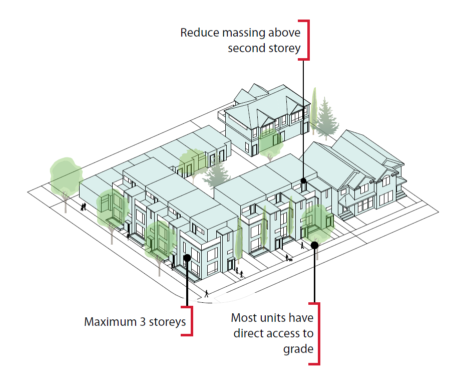
BUILDING SCALE
Scale Modifiers
Scale refers to the combination of height and massing of a structure. Scale modifiers are applied to urban form categories to indicate the general scale and anticipated human experience at the street level. The scales are grouped by compatible built forms with similar design standards to manage the experience of height and massing for people at the street level.
The Guidebook outlines five scale modifiers that apply to the Neighbourhood and Industrial Transition areas. Four of these modifiers have been used in the North Hill Communities scale map. When we applied scale, we considered the future anticipated activity level of an area to ensure that the scale will support enough intensity to make the anticipated activity level viable.
In general, many people are needed to support a retail area so larger scale buildings near high-activity areas will help to support their success, while an overly restricted building scale will reduce their viability. A variety of scales have been applied across the communities to provide opportunity and choice and contribute to the diversity of the North Hill Communities, map provided below.
BUILDING SCALE MAP

SCALE MODIFIER DEFINITIONS
| Limited Scale
|
|
| Low Scale
|
|
| Mid Scale
|
|
| High Scale
|
|


Refer to the gallery below for further examples of scale.
Limited Scale Examples
Low Scale Examples

Mid Scale Example

High Scale Example

SUPPORTING GROWTH OBJECTIVES
Supporting Growth Goals, Objectives, and Implementation Options
Through chapter three of the local area plan we look to identify what physical and social investments are needed to support the growth vision.
The below chart illustrates growth objectives and a list of supporting implementations options identified to support the objective.
What is a supporting growth objective? To support the vision set out in Chapter 1 of this Plan, we have included supporting growth objectives to identify where and how growth can be supported at the local level. The objectives represent the future or desired result that the plan commits to achieve. They apply at the community-wide level (i.e. they’re not site specific) and provide benefit to more than one resident. The objectives are long-term, durable and are intended to be actionable.
What is an implementation option? Implementation options have been identified by stakeholders through public engagement conducted during the drafting of this Plan. As noted in Chapter 3, these actions represent steps community stakeholders identified to achieve the support growth objectives of the Plan. The list below represents a snap shot in time based on feedback collected to date. It is expected that the list will be updated based on further engagement as part of this project as well as projects in the future. In addition, this list will be updated as actions are implemented and additional actions are identified. The items listed here will be used by City Service Lines and other departments as inputs and consideration into future budget decisions. The local area plan will not implement these actions but the list will be used to inform future budget allocations.
| North Hill Communities Supporting Growth Objective | Implementation Options |
| Celebrate, care for, and, where appropriate protect, the heritage of the communities |
|
| |
| Improve and enhance
existing community association buildings and related facilities within the
North Hill Communities |
|
| Improve safety and comfort in existing parks and, where feasible, support a broader range of complementary uses that cater to diverse groups of users. |
|
| Improve and enhance existing public recreation facilities |
|
| Improve the quality of the pedestrian realm along Main Streets, station areas, and activity centres |
|
| Improve pedestrian connections and complete missing links between Main Streets, station areas, activity centres, parks and natural areas |
|
| Explore opportunities for additional on-street parking along Main Streets |
|
| Improve transit connections inside and outside of the North Hill Communities |
|
| Improve safety, connectivity, and accessibility for all modes of Transportation |
|
| Expand the cycle network across the plan area, provide improved connections and complete missing links between Main Streets, station areas, activity centres, parks, and natural areas. |
|
| Connect and enhance the east-west cycle connections to destinations within the plan area and beyond such the University of Calgary and SAIT |
|
| Support and expand the tree canopy throughout the plan area |
|
PROVIDE YOUR INPUT
We want to hear your thoughts on the draft plan! Please click through the tabs below to share your thoughts on the various plan sections. This will be open for comments until December 8.
DRAFT VISION & GUIDING PRINCIPLES
The Vision
The North Hill Communities are a collection of some of Calgary’s first street-car suburbs. They are historic, vibrant, and accessible communities where a range of people choose to live, do business, and play. As the North Hill Communities continue to evolve, they will build upon their rich history and eclectic neighborhood character. Through high-quality, people focused development, the North Hill Communities will accommodate a diverse population, enhanced amenities, strong transportation connections, mix of housing types, vibrant main streets, and an accessible network of parks and open spaces.
Guiding Principles
Through engagement in phase one, The City and Working Group developed Guiding Principles for the project. Click here to review the results of phase one engagement.
The Guiding Principles have been listed below, with a response of how these have been addressed and considered in the draft plan. Please review each principle and provide a response that reflects how you feel about the statement "The local area plan has appropriately addressed and considered this guiding principle." If you disagree with the statement, we would like to know why.
DRAFT MAPS
Map 3: Urban Form
Map 3: Urban Form identifies and categorizes the
purpose, general function and activity levels of different parts of a
community. These categories are focused on the street experience and not
related to building scale. The map demonstrates how the different areas of a
community relate to and support each other.
The urban form map is in the gallery below for further review and background on the urban form classification system has been provided above to aid your interpretation. After you have reviewed the draft urban form map, please provide your comments below. Review the image of the Urban Form Map below or review and zoom in on the PDF here.
Map 4: Building Scale
Scale refers to the combination of height and massing of a structure. The scale map identifies the general scale and anticipated human experience at the street level. Scale has been applied to ensure enough intensity to make the future anticipated activity level viable.
It is important to note that the land use bylaw will supplement building scale modifiers by more specifically regulating height, floor area ratios and transition.
The building scale map is provided in the gallery below or you can review and zoom in on the PDF here. Background on the scale modifiers have been included in the tabs above and will aid your interpretation of the scale categories.
IMPLEMENTATION OPTIONS
Further background on this section has been provided under the tab above "SUPPORTING GROWTH OBJECTIVES".
Please review the above information and provide your answers to the list of questions below.


