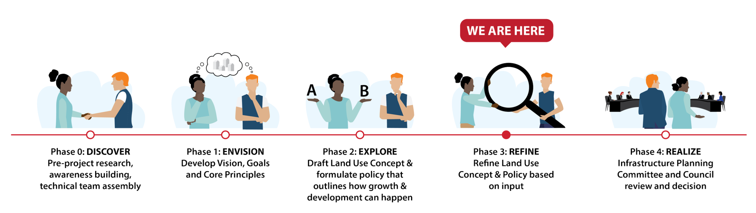
Phase 3 - Refine
We are currently in Phase 3 of creating an Area Structure Plan (ASP) for lands south of Pine Creek, and west of Macleod Trail. During this phase we will refine the land use concept and policy based on the input we received from the first two phases of engagement. We're asking residents to share your thoughts about the draft plan before Phase before it is presented to City of Calgary Committee and Council in July.
Draft Vision
The Saatootsi (West Macleod Residual Lands) ASP Lands will be a thriving, inclusive community with diverse housing options, convenient access to jobs, schools, and shops, and strong support for active lifestyles. Pine Creek and nearby natural spaces will be preserved through new parks and trails that will foster wellness and sustainability. Thoughtful planning will create a walkable, accessible neighbourhooods that respect Indigenous cultures and accommodate growth in a responsible manner.
Draft Land Use Concept

Phase 3 key changes
After hearing from interested parties, some of the key changes to the draft Saatootsi (West Macleod Residual Lands) Area Structure Plan draft include:
- Increased the areas subject to Environmental Open Space Study Area (most notably preserving the North Pine Creek area).
- Renamed Multi-Residential Overlay to Medium-High Density Residential and revised its location closer to a future LRT station.
- Increased the areas subject to Ground-Oriented Residential Flex to accommodate better flexibility within the land use area.
- Retained Floating Commercial and renamed to Commercial Flex.
- Relocated the Special-Purpose Recreation site to serve local and regional residents with easy access.
- Removed the high streets and replaced it with an Active Frontage Area in the south.
- Identified central locations for Joint Use sites.
- Refined location for Commercial area in the south.
- Retained Southern Buffer and renamed to Southern Municipal Interface,
- Refined pathways and active mode connections,
- Refined access points into the Plan Area.
Main ideas:
- Distinct residential land use areas.
- Commercial and Mixed-Use opportunities.
- A conceptual street network.
- Two neighbourhood activity centre locations.
- A proposed special-purpose recreation site.
- Two green buffers (north and south).
- Two proposed entrance gateway locations
Draft ASP Highlights
- Compact, future-ready and Transit Oriented Development (TOD) ready.
- Integrates closely with adjacent development.
- Forward planning to ensure infrastructure and access are ready to support development.
- Planning for flexibility that allows for adapting to market needs while supporting more houses.
- Resilient, connected and reflects local culture and values.
- Strong emphasis on better transportation, more housing choices, protecting nature, and honouring Indigenous history and presence.
- Modern and efficient planning for new areas to work well with public transportation and nearby developments.

Key Planning Considerations
Access challenges:
- North due to Pine Creek natural area
- West due to CPKC heavy rail
- East Macleod Tr S.W. has access limitations
- South access is possible requiring coordination and collaboration with Foothills County & ATEC
Additional considerations:
- Preserving Pine Creek natural area
- Future Belmont/210 Ave south LRT Station
- Fragmented land ownership
- Amenities and future communities being built surrounding the plan area
- Potential for future development south of Hwy 552
- Opportunity for higher density with variety of housing typology

FAQs
As we went through the last two rounds of engagement, we heard from a number of interested parties. As we created the draft ASP part of the vision was to respect Indigenous culture, while accommodating growth in a responsible manner.
Saatootsi means west in Blackfoot and symbolizes natural forces like chinooks, winds and hot springs that shape the region. It reflects a deep, spiritual connection to the land and nature, and is rooted in the landscape, emphasizing harmony with all living and non-living elements.
The Saatootsi (West Macleod Residual Lands) sets a long-term vision for development and addresses key needs:
- New homes for a growing Calgary - plans for a variety of housing options for about 12,000 to 20,000 future residents.
- Protecting nature and open spaces – supports the preservation of identified wetlands, creeks, and natural areas while creating parks & pathways that connect community to landscape.
- Better transportation and future transit – lays out safe, connected street networks with future transit routes, bike paths and walkable streets.
- Providing everyday amenities – includes space for schools, local parks, and small-scale shops to support day-to-day life close to home.
- Supporting jobs and local business – designates areas for employment and commercial activity, creating job opportunities within the community.
- Building for a changing climate – the plan encourages climate resilient designs for a more sustainable future.
- Aligning with Calgary’s long-term plans – supports The City’s sustainability principles and key directions as outlined in the Municipal Development Plan (MDP).
The project team considers feedback, input and ideas from the public, landowners, and other interested parties. Many aspects are being considered as part of developing this ASP, including but not limited to:
- Higher order policies and Council direction.
- Transportation and transit.
- Parks and open spaces.
- The environment, natural areas and climate.
- Water, wastewater, and stormwater services.
- Collaborating with Foothills County and other nearby developments.
- Community amenities like schools.
- Historical, archaeological, and cultural aspects
- Urban design and public spaces.
- The surrounding area and future development possibilities.
The Municipal Development Plan sets a minimum average of 20 units per hectare (about 8 units per acre) for new residential areas. The goal is to reach at least 30 units per hectare, but we expect the average to be closer to 40 unis per hectare (16 units per acre). Overall, the density will likely fall somewhere between 30 and 50 units per hectare (12 to 20 units per acre).
There will be approximately 5,000 to 8,000 units anticipated if the above density targets are achieved. Development beyond 6,000 units will require further studies and feasibility analysis.
There is no current policy guidance LRT extension to these lands that would extend south of 210 Ave SW. The ASP has included enabling policies that support Transit Oriented Development (TOD) in case the Redline LRT does extend further south.
This ASP supports Transit-Oriented Development (TOD) by encouraging compact, walkable, and mixed-use communities within 600 metres if the red line is extended to these lands. While final station locations aren't confirmed, the policies within the ASP allows development to move forward now in ways that prepare for future transit.
Key features include:
- Increased density and mixed-use potential near possible future stations.
- Flexible building forms that can adapt as transit plans evolve.
- Strong emphasis on walking, biking, and easy access to transit.
- Reduced parking requirements and improved pedestrian-friendly public spaces.
Overall, development in the TOD-supportive area is designed to be transit-ready and aligned with Calgary’s broader TOD guidelines, without needing to amend the ASP.
Building heights are intentionally scaled to reflect the intended character, density, and function of each residential area. Heights increase near transit corridors and activity centres to support density, walkability and community services.
Ground-oriented residential areas (up to 3 storeys)
- Designed for lower-density homes like single-detached and rowhouses.
- Up to 3 storeys allowed near key corridors or centres, if impacts are minimized.
- Focus: Family living, neighborhood character, and privacy.
Ground-oriented residential flex areas (up to 4–6 storeys)
- Allows more housing types, including stacked townhomes and low-rise apartments.
- Height must transition sensitively near low-density areas.
- Focus: Flexibility, housing variety, and gradual intensification.
Multi-unit residential areas (4–6 storeys, up to 12 in key locations)
- Mid-rise buildings near transit and amenities.
- Up to 12 storeys allowed in transit areas or corridors if designed to reduce shadow and privacy impacts.
- Focus: Medium-density living, transit support, and urban form.
Medium-high density residential areas (7–16 storeys)
- Taller buildings with mixed uses (residential, retail, office) in urban hubs.
- Design must minimize shadowing and ensure good integration with surroundings.
- Focus: Urban vibrancy, density targets, and mixed-use development.
The access challenges to the plan area are addressed in multiple ways, including:
- An interim connection from MacLeod Trail in the middle of the plan area.
- A planned bridge across Pine Creek connecting to 210 Ave S.W.
- A half interchange at Macleod Trail and Highway 552.
- Two active modes connections and multiple pathways.
With these infrastructure improvements and multi-modal connectivity, it is expected that the future and existing residents will have an efficient connection to their destinations.
The plan has factored in existing natural areas as part of Environmental Open Space Study Area (EOSSA) and it is expected that most of it will be preserved as an Environmental Reserve (ER) based on technical studies.


