The Final Draft Area Structure Plan is Ready
The final draft Saatoohtsi (West Macleod Residual Lands) Area Structure Plan is ready for review. The final draft includes policies that will guide future growth and development of the lands in Southwest Calgary over the next 20 to 30 years.

Highlights of changes
As part of the process, key considerations including technical studies, public input and City direction have influenced some changes that are included in the final draft Saatoohtsi (West Macleod Residual Lands) Area Structure Plan. Here is a quick summary of some of the changes in the final draft ASP.
Content and structure updates
- Corrected Plan name - updated from Saatootsi
to Saatoohtsi to reflect accurate Blackfoot language, based on
expert guidance.
- New policy sub-section on slope hazards (Section
4.1) - provides guidance on how to manage risks from unstable ground
and slopes to ensure building projects are safe.
- New section on Macleod Trail interface (Section
4.6) - added to guide transition, design, and access along this major
roadway.
- Reorganized emergency response section - content
moved under Community and Neighbourhood framework as Section 3.10.
- Removed performance monitoring section to reduce
duplication.
Policy and language refinements
- Renamed “Special-Purpose Recreation Site” to “Recreation Site.”
- Removed the standalone “Indigenous Relations” implementation section and integrated content into Historic and Contemporary Matters of Significance to help content fit together better.
- Updated history section with minor refinements to language to better reflect local context and Indigenous perspectives.
- Removed or merged duplicate policies across sections (e.g., mobility, environment, public realm) to reduce redundancy and improve clarity.
- Refined and repositioned “Intent” statements for consistency and to ensure it linked well to corresponding policy content.
- Shifted the tone of several policies (e.g., mobility, housing, cultural) from focusing on procedure to focusing on outcomes.
Policy tone and flexibility enhancements
- Policies were refined to support long-term
adaptability and resilience, addressing evolving needs in areas like
mobility, and infrastructure phasing.
- Shift from “shall” to “should” - updated language across policies to offer more flexibility while maintaining clear guidance and enabling application of the policies in ways that fit local context.
Mapping and appendices
- Improved visual clarity and accuracy across land
use, mobility network, natural systems, and open space maps.
- Updated appendices to reflect latest technical
information.
Vision
Goals
The Plan Area will offer a variety of housing types to support multi-generational living. Housing forms will range from higher-density developments to lowerdensity and ground-oriented options, ensuring that all residents have access to housing that meets their needs, preferences, and life stages.
The Plan Area recognizes the importance of protecting natural features and celebrating cultural identity. Pine Creek and its surrounding landscape will be preserved to maintain ecological function and serve as a vital wildlife corridor. Indigenous history and cultural contributions will be respectfully recognizing through design, interpretation, and place-based storytelling.
A range of community amenities will be integrated into the Plan Area to support healthy, active, and connected lifestyles. Schools, childcare, parks, local commercial services, and recreational spaces will be located to enhance walkability and foster social interaction. These spaces will promote placemaking, cultural expression, DRAFTand a strong sense of community.
The inspiration for future community design will support multiple ways of getting around, including walking, wheeling, public transit, and driving. While early phases of development will rely primarily on vehicular access, the long-term vision supports a gradual transition towards enhanced active transportation, transit integration, and reduced reliance on personal vehicles. The mobility network will ensure accessible, safe and convenient access to key destinations within and beyond the Plan Area, encouraging active transportation and reducing reliance on private vehicles
The Plan Area will incorporate strategies to support climate resilience and long-term environmental sustainability. This includes advanced water management, low-impact development, and energy efficient infrastructure aimed at reducing greenhouse gas emissions. These measures will contribute to a more sustainable, adaptable, and future-ready community.
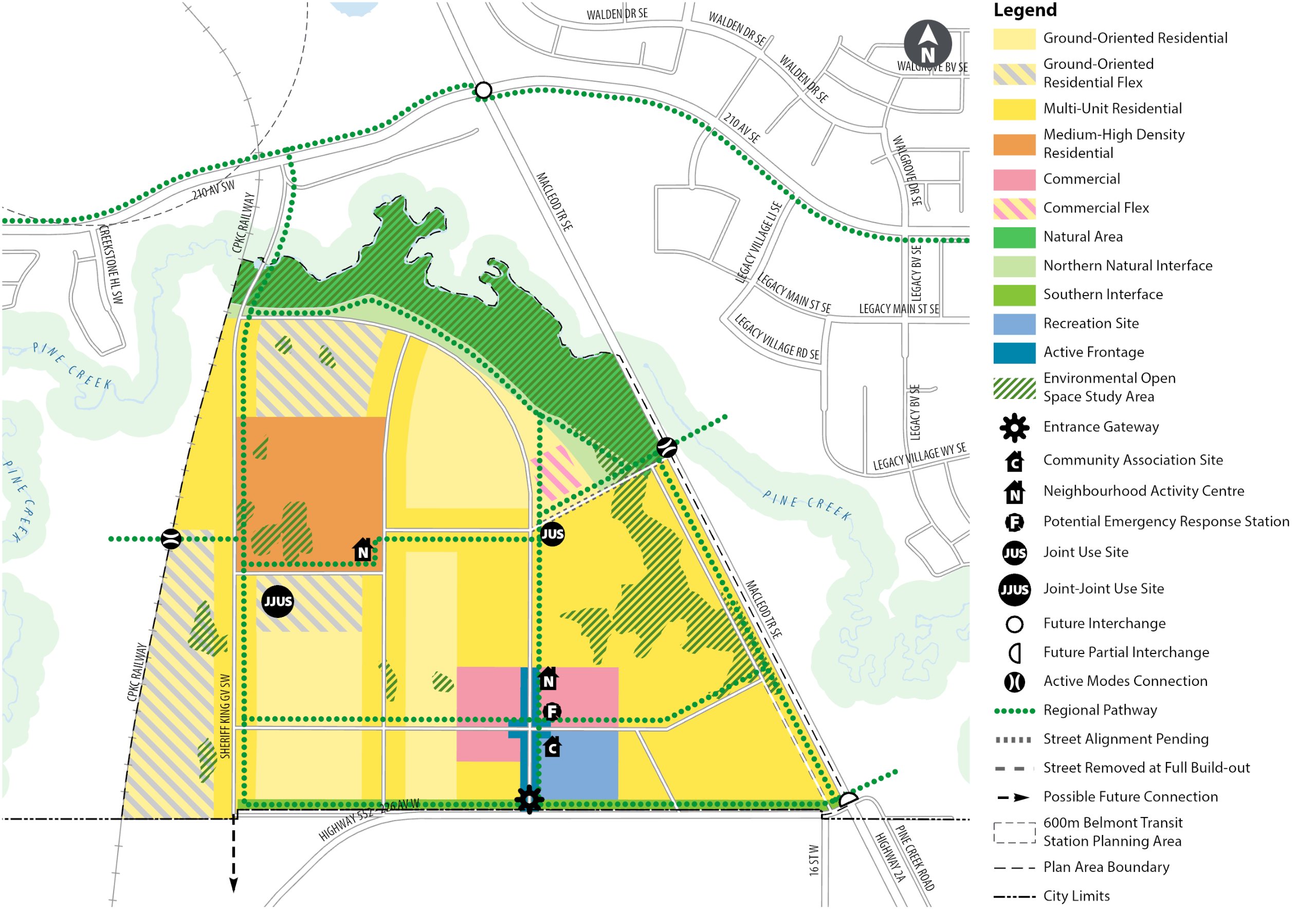
Share Your Thoughts with Committee
Committee Date
The proposed Plan will be brought forward to the Infrastructure and Planning Committee (IPC) for review and decision on Monday, July 21, 2025.
Public Submissions
Anyone who is interested can participate in the public hearing of Committee and/or Council. You can submit your comments in writing, register to speak or watch proceedings online.
Submissions should clearly state that the comment is for the "Saatoohtsi (West Macleod Residual Lands) Area Structure Plan". The deadline to have your public submission added to the agenda is 12 p.m. (noon) on July 14, 2025.
- Public Submission to City Clerks – select “Request to speak” or “Submit a comment”
- Council and Committee webcasts
- Council and Committee Agendas, Minutes and Video
Watch Committee and Council hearings via live webcast.
Public Hearing Process
Are you interested in submitting comments or speaking at committee? Learn more about the process here.
The agendas will be posted a few days prior to the hearings at the link below:
About
You see the results of decisions made by The City of Calgary every day. Get involved and provide your input on City projects and programs. Together we can build a better city.
Contact Us
Have questions or want to learn more about a project, contact us below:
Phone | 311 or 403-268-CITY (2489) |
---|---|
engage@calgary.ca | |
Website | www.calgary.ca |