THANK YOU FOR YOUR INPUT!
Opportunities for input in this phase were open from March 7 - April 4, 2022, but are now closed.
A record of what we asked for input on in this phase is below. A What We Heard report (outlining all feedback captured through online feedback and other feedback opportunities in this phase) will be shared when we launch the next phase of engagement (anticipated for June 2022).
Thanks again to everyone who took the time to get involved in this phase. We're looking forward to connecting with you again soon. Sign up for email updates to find out about upcoming opportunities to get involved.
YOUR VOICE MATTERS
Community redevelopment – it’s complex. Let’s chat about what’s driving change, where growth could be focused, where larger buildings could go, and what direction is needed to ensure new development integrates well into your community.
The following topics were open for input from March 7 - April 4, 2022:
TOPIC 1: Focus areas for growth and change
Let’s start by exploring opportunities where new moderate to large-scale homes and businesses (4+ storeys) might be appropriate in the area.
New moderate to large-scale buildings for homes and businesses give more people the option of living near local amenities, shops, and restaurants and provides all locals with increased access to a greater variety of amenities and services nearby.
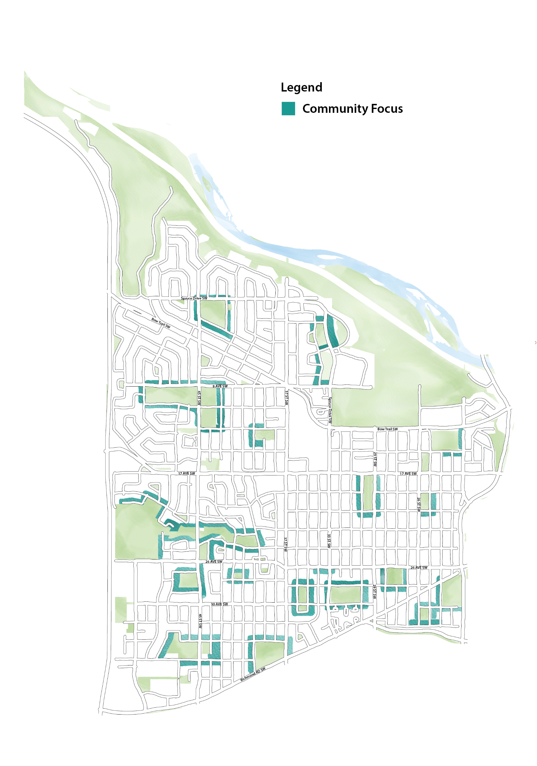
Three growth focus areas – where moderate to large-scale growth (4+ storeys) could be focused include:
Additional growth of 4+ storey homes and businesses around Transit Hubs and Activity Centres would mean that more people could be within walking distance of transit and may not need to own a vehicle to get around.
This could help reduce emissions, reduce road congestion and support transit ridership and efficiency. Additional homes, businesses and people around Transit Stations could help make these areas destinations to visit and spend time versus places to travel through, improving vibrancy and safety.
![]()
*right click on image and open in new tab to expand
Learn about more about the Transit Station & Activity Centre theme
Allowing for additional growth of this type along key corridors would mean that more people could live near local amenities, schools, shops and restaurants. Many corridors are supported by transit and cycling routes and allowing more homes along these corridors means more people could choose to use transit, cycling or walking to get around.
Additional homes and businesses along corridors support street vibrancy and creates new local destinations to visit. Imagine more people walking down sidewalks, sitting at café tables or park benches and riding by on buses or bicycles.
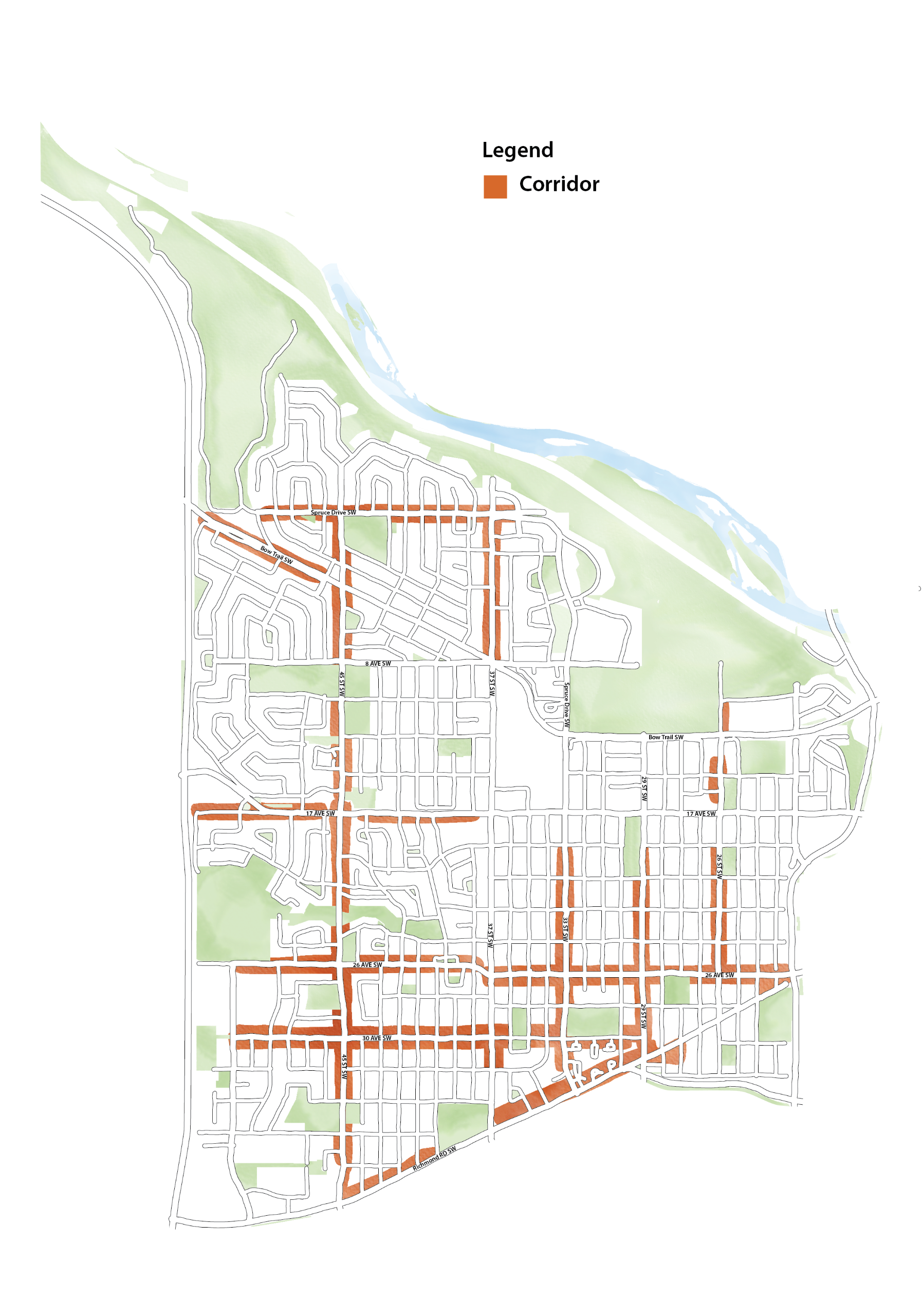
*right click on image and open in a new tab to expand
Allowing for additional growth of this type around parks and open spaces would mean that more people have easy access to parks and green space.
With more people living around parks, they would be used more and may also draw businesses like coffee shops, daycares, or art studios to open there.
*right click on image and open in a new tab to expand
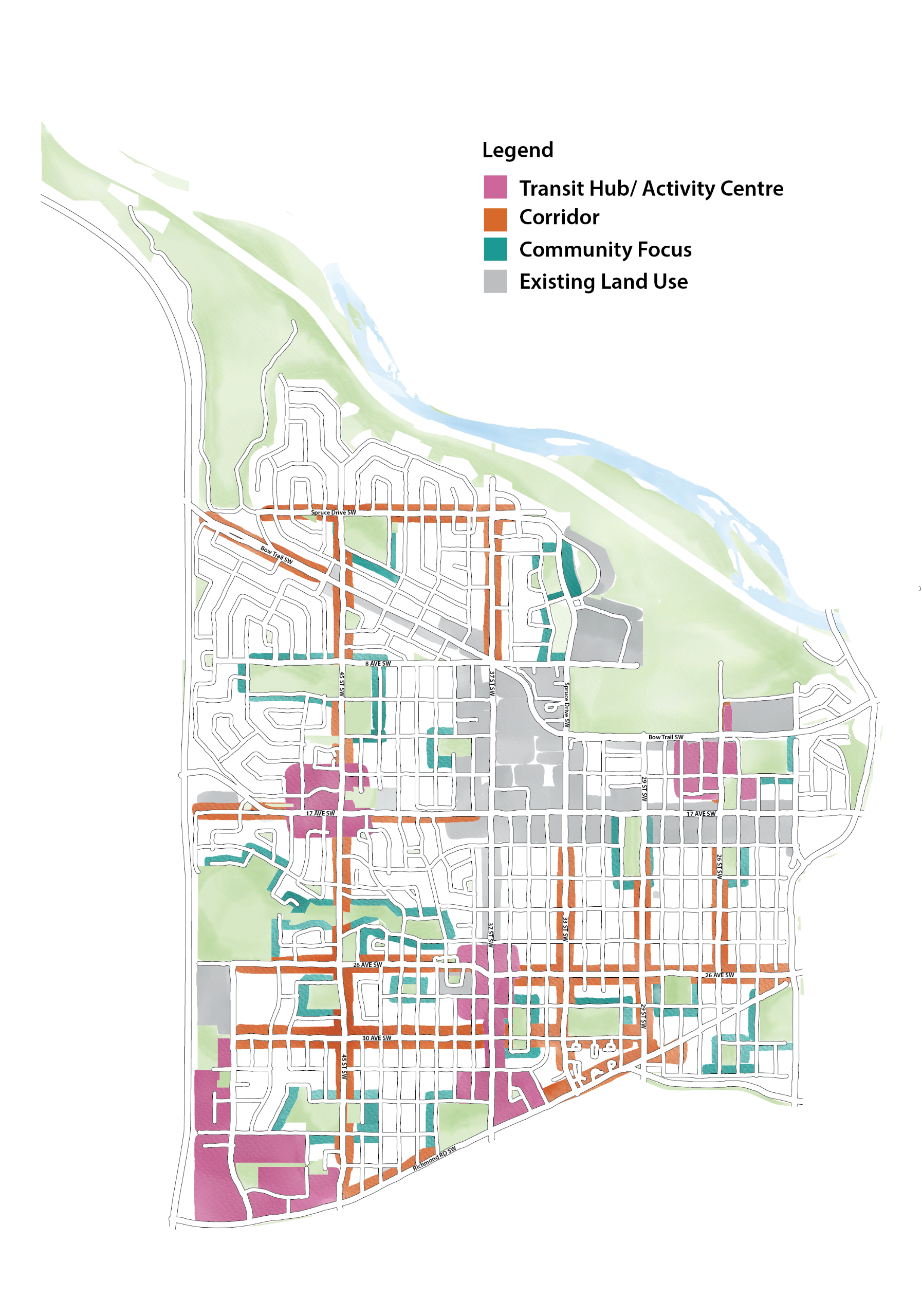
As a starting point, let’s review the establish policy direction and land use that already exists today.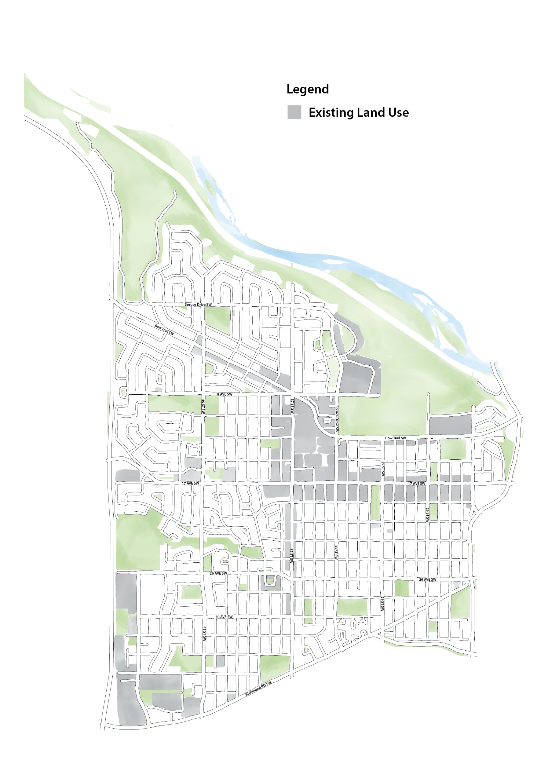
Previous Council adopted polices such as the Westbrook Station Area Plan and the Shaganappi Point Station Area Plan support new moderate to large buildings in the vicinity of Westbrook and Shaganappi Point LRT stations. The Westbrook Station Area Plan supported tall buildings throughout the station area (between Bow Trail, 33 Street, 17 Avenue and 37 Street), typically up to 12 stories. Towers (up 100 metres or approximately 30 stories) were allowed in a few key locations immediately to the west of the station entrance and along Bow Trail. The plan also supported lower height buildings (four to six storeys) within a few blocks of the station area. Much of this policy has been supported by land use changes, so zoning is in place for most of these areas. The Shaganappi Point Station Area Plan supported four to five storey buildings along 12 Avenue between the east side of 26 street and 31 Street.
In addition to Council adopted policies that accommodate new growth, existing land use (zoning) that accommodates moderate to larger buildings is found throughout the plan area. This existing land use (zoning) might be the result of a recent developer led redesignation (rezoning) application, the product of a city-led rezoning initiative such as the Main Streets program, or may have been in place since the community first developed. The Main Streets program redesignated (rezoned) properties along 17 Avenue and 37 Street and within a few blocks in the vicinity to allow for four to six storey buildings.
Input shared through previous engagement, Westbrook Communities’ Core Values, and existing policy and land use (zoning) in the area were key considerations as proposed focus area for growth were determined.
Keep in mind that these potential focus areas for growth are an initial starting point for discussion. For example, many areas may only be appropriate for 4 storey buildings, or maybe less. Many areas are already zoned or have existing policy direction for large buildings.
These areas will be refined based on input collected in this phase and a revised and more detailed map will be shared in the next phase, with additional opportunities for input.


What do you think? Provide your input.
TOPIC 2: Direction for growth and development
As growth and development continue to occur, it’s important new development is designed in a way that integrates well into the community and with its surroundings.
A local area plan includes guidance and direction (development polices) that are reviewed when new proposals to rezone or develop a new building are brought forward by property and landowners in the area.
We want to ensure new growth and development integrates well into the community and aligns with the Vision & Core Values that have been established to help guide growth and change in the Westbrook Communities area.
The Land Use Bylaw contains rules about the design and use of buildings in general, but sometimes more detailed guidance or direction is needed for development.
Development policies are created and included in local area plans to provide direction within a specific geographic area. Perhaps additional direction is needed to support the Core Values.
Development policies may address building orientation (where building entrances and various functions are located), massing (whether upper floors should step back from lower floors), materials (using durable materials such as masonry, metal or brick on particular areas of a building), parking (the amount of parking provided and where it should be located) and landscaping (where landscaped areas should be located and any considerations for types of planting), among others.
In this phase of engagement, we’re looking to create and refine development direction (policies) to help ensure growth and development integrates well into the Westbrook Communities area. The development direction outlined below is linked to the Westbrook Communities’ Core Values that were created with the public through the last phase of engagement.
The following guidance and direction is linked to each core value:
Image 1 of 8


