South Shaganappi Communities Local Area Plan
The South Shaganappi Communities Local Area Plan project has now concluded. For the most up-to-date information, please click the link below.
South Shaganappi Communities Local Area Plan Approved by Council
On March 4, 2025, Council approved the South Shaganappi Communities Local Area Plan, with amendments, in a 11-2 vote.
Summary of Council-approved Amendments:
Council directed Administration to change the Silvera for Seniors site in Varsity to a Comprehensive Planning Site. This includes changing the scale from Low (up to 6 storeys) to no building scale on the Building Scale map and adding Comprehensive Planning Site to the Urban Form Map. Policy will also be added that speaks to any land use amendment applications on the Silvera for Seniors site will require an amendment to Map 4: Building Scale.
This Council-directed amendment requires readvertising and will be brought forward to Council on April 8, 2025 as an amendment to the Plan that was approved on March 4, 2025.
As The City is no longer required to circulate local area plans to the Calgary Metropolitan Region Board, and no longer required maps that reflect the Growth Plan, amendments were made to remove this content from the Plan. Amendments included removing Appendix B and other references to the Regional Growth Plan.
Amendments were made to change the urban form category for a portion of 29 Street NW from Neighbourhood Connector to Neighbourhood Local and to amend the building scale from Low (up to 6 storeys) to Low-modified (up to 4 storeys). Amendments were also made to change the area south of 13 Avenue NW, west of University Drive NW from Low (up to 6 storeys) to Limited (up to 3 storeys).
Amendments were made to incorporate a new section in Chapter 3 of the Plan that speaks to Uxbridge Drive NW and improving mobility options, providing a safe and continuous pedestrian and cycling infrastructure, providing pedestrian and cycling connections to the central open space, implementing traffic calming measures, and monitoring and addressing traffic concerns.
The South Shaganappi Communities Local Area Plan (Plan) is the result of over two years of engagement with participants including youth, seniors, residents, business owners, community association and development industry representatives, and a dedicated and diverse working group. Feedback provided by participants throughout the process helped shape and refine the Plan that was brought forward to Council. A recording of Council, presentation and attachments can be viewed online here.
The Plan sets out the vision and policies to guide growth, change and investment over the next 30 years in the communities of Banff Trail, Montgomery, Parkdale, Point McKay, St. Andrews Heights, University Heights, University District, Varsity, and the University of Calgary. In addition to policies directing how land can be used and redeveloped in the area, the Plan identifies community improvements and investments to support communities as they experience growth and change.
With the approval of the South Shaganappi Communities Local Area Plan, there is now direction on future development, investment and community improvements that residents, landowners, builders/developers, planners and Councillors can commonly refer to when new development and investment ideas are proposed.
The Plan aims to support the area as it evolves by:
- Supporting diverse housing options to meet the evolving needs of existing and future residents.
- Improving connectivity for all mobility options between destinations within and beyond the Plan Area.
- Strengthening transit station areas as community hubs for services and amenities.
- Providing affordable and accessible recreational opportunities for all.
- Enhancing and conserving existing parks, open spaces, and natural areas.
Thank you to everyone who dedicated their time and provided input throughout the creation of the South Shaganappi Communities Local Area Plan. Your contributions and the contributions of others who are passionate about this area helped shape the Plan that has been approved. Your interest, time and dedication are invaluable and truly appreciated.
POST-COMMITTEE UPDATE
On January 30, 2025, the Proposed South Shaganappi Communities Local Area Plan was presented to the Infrastructure and Planning Committee (IPC). The Plan was recommended for approval with amendments (expand accordion below for details).
The updated version of the South Shaganappi Communities Local Area Plan will be brought forward to a Public Hearing of Council for review and decision on March 4, 2025.
A detailed list of the amendments approved by Committee can be found in the Infrastructure and Planning Committee Minutes from January, 30, 2025 and below.
- Amend Map 3 entitled “Urban Form” by changing “Neighbourhood Connector” to “Neighbourhood Local” along Varmoor Road NW; and
- In Section 2.5.6.2 b insert the following subsection:
“i. Development between 32 Avenue NW and Varmoor Road NW, with the exception of grade oriented low density residential should:
a. Contribute to enhanced public spaces along both roadways;
b. Provide direct sidewalk connections to both roadways;
c. Have vehicular access off Varmoor Road NW;
d. Locate waste and recycling inside of buildings or enclosures; and,
e. Integrate through pedestrian connections between the two roadways.”
- Amend Map 3 entitled "Urban Form" by changing "Neighbourhood Connector" to "Neighbourhood Local" on Valparaiso Place NW;
- Amend Map 4 entitled "Building Scale" by changing "Low - Modified (up to 4 Storeys)" to "Limited (up to 3 Storeys)" on Valparaiso Place NW; and
- In section 2.5.4.4, Figure 10 remove Valparaiso Place NW from Dalhousie Transition Zone.
- Amend Map 3 entitled "Urban Form" by changing "Neighbourhood Connector" to "Neighbourhood Local" on Varsity Estates Link and Varsity Estates Grove NW;
- Amend Map 4 entitled "Building Scale" by changing "Low - Modified (up to 4 Storeys)" to "Limited (up to 3 Storeys)" on Varsity Estates Link NW and Varsity Estates Grove NW;
- In section 2.2.1.4.c.iii. replace the subsection with the following subsection: “Consider shadowing impacts on neighbouring properties, parks; and,”
- Amend Map 4 entitled "Building Scale" by changing "Mid (up to 12 Storeys)" to "Low (up to 6 storeys)" at 5200 – 53 Avenue NW currently developed as Varsity Estates Village NW.
- Amend Map 2 entitled "Community Characteristics and Attributes" by defining the boundaries of the "Neighbourhood Activity Centres" that are identified on the map.
- Develop figure maps for the following Area Specific Policy section where each figure map will include road names that are identified in the corresponding policies, boundaries for the Area Specific Policy section, and additional details that may support the intent of the Area Specific Policy section:
a. 5.2.1 – Bowness Road NW Neighbourhood Main Street
b. 5.2.2 – 16 Avenue NW Neighbourhood Main Street
c. 5.3.1 – 16 Avenue NW Urban Main Street
d. 5.5.2 – CF Market Mall Community Activity Centre
e. 5.5.4 – Parkdale Neighbourhood Activity Centre
f. 5.5.5 – University Heights Neighbourhood Activity Centre
g. 5.5.6 – Varsity Neighbourhood Activity Centre
h. 5.6.1 – 19 Street NW
i. 5.6.2 – 32 Avenue NW
j. 5.6.3 – Varsity Drive NW
k. 5.6.4 – Morley Trail NW
Hey South Shaganappi Communities! The UPDATED proposed Plan is ready.
Proposed Plan
PROPOSED PLAN
Proposed Plan Presented to Committee
On January 30, 2025, the Proposed South Shaganappi Communities Local Area Plan was presented to the Infrastructure and Planning Committee (IPC). The Plan was recommended for approval with amendments.
The UPDATED Proposed Plan (including Committee-approved amendments) for Council Review
The updated Proposed South Shaganappi Communities Local Area Plan has been revised to include all Committee-approved amendments. All Committee-approved amendments can be found in the Infrastructure and Planning Committee Minutes from January, 30, 2025 or above.
UPDATED Proposed South Shaganappi Communities Local Area Plan
PLAN VISION & KEY MOVES
The South Shaganappi Communities will continue to develop into a well-connected, innovative hub that supports recreation, economic activity, and livability through inclusive and vibrant mixed-use spaces and natural areas that are anchored by the regionally recognized University of Calgary, Foothills Medical Centre, and Alberta Children’s Hospital.

- Providing diverse housing types and choices throughout the Plan Area that respond to the changing needs of Calgarians, including age, ability, and lifestyle choices.
- Supporting and enabling the provision of diverse housing options including student housing, mixed-market housing, and non-market housing, especially in proximity to the major institutions of the University of Calgary, Foothills Medical Centre, and Alberta Children’s Hospital.
 Improving connectivity for all mobility options between destinations within and beyond the Plan Area
- Highlighting opportunities to improve streets, pathways, and linkages to key destinations such as transit, institutions, shopping, and places of employment.
- Identifying community corridor improvements throughout the Plan Area including Varsity Drive NW, 40 Avenue NW, 32 Avenue NW, 3 Avenue NW/Parkdale Boulevard NW, Morley Trail NW, 24 Avenue NW, 19 Street NW, 29 Street NW, and Home Road NW.
- Enabling people to live closer to public transit and improving connectivity through concentrating growth around areas served by public transit, transit station areas, and higher activity residential streets that link destinations to one another.
![]() Strengthening transit station areas as community hubs for services and amenities
Strengthening transit station areas as community hubs for services and amenities
- Concentrating growth around the Red Line LRT and MAX Orange BRT stations, applying the highest building scales and a greater mixture of urban form categories to enable transit-oriented development.
- Supporting transit station areas as vibrant community hubs with services and amenities including publicly-accessible infrastructure.
- Identifying opportunities for public space and pedestrian experience improvements within the Banff Trail transit station area, as a place to connect people to transit, shopping, McMahon Stadium, and Foothills Athletic Park/ Foothills Multisport Fieldhouse.
 Providing affordable and accessible recreational opportunities for all
- Supporting recreational opportunities that are affordable and accessible for residents of all ages, abilities, and cultural backgrounds.
- Identifying improvements to existing recreational opportunities including Shouldice Athletic Park, Foothills Athletic Park/Foothills Multisport Fieldhouse, and community facilities and spaces throughout the Plan Area.
 Enhancing and conserving existing parks, open spaces, and natural areas
- Highlighting opportunities to enhance and invest in existing parks, open spaces, and natural areas including Shouldice Park, Dale Hodges Park, and community parks throughout the Plan Area.
- Recognizing the unique feature and significance of the Bow River pathway system by considering transitions in building scales towards the river and providing community improvements to protect and enhance natural areas surrounding the pathway.
Learn more about the key aspects of the Plan and how to read the Plan in the new Executive Summary (pages 2 to 11) of the proposed Plan.
PROPOSED PLAN UPDATES
The Summary of Proposed Plan Updates provides an overview of the edits that have been made to the proposed version of the Plan. Proposed Plan updates include:
- the addition of an Executive Summary
- a new core value illustration
- mapping and clerical updates
- new Chapter 3 illustrations
Additionally, on January 30, 2025, the Proposed South Shaganappi Communities Local Area Plan was presented to the Infrastructure and Planning Committee (IPC). The Plan was recommended for approval with amendments. A detailed list of the amendments approved by Committee can be found in the Infrastructure and Planning Committee Minutes from January, 30, 2025 and below.
A detailed list of the amendments approved by Committee can be found in the Infrastructure and Planning Committee Minutes from January, 30, 2025 and below.
- Amend Map 3 entitled “Urban Form” by changing “Neighbourhood Connector” to “Neighbourhood Local” along Varmoor Road NW; and
- In Section 2.5.6.2 b insert the following subsection:
“i. Development between 32 Avenue NW and Varmoor Road NW, with the exception of grade oriented low density residential should:
a. Contribute to enhanced public spaces along both roadways;
b. Provide direct sidewalk connections to both roadways;
c. Have vehicular access off Varmoor Road NW;
d. Locate waste and recycling inside of buildings or enclosures; and,
e. Integrate through pedestrian connections between the two roadways.”
- Amend Map 3 entitled "Urban Form" by changing "Neighbourhood Connector" to "Neighbourhood Local" on Valparaiso Place NW;
- Amend Map 4 entitled "Building Scale" by changing "Low - Modified (up to 4 Storeys)" to "Limited (up to 3 Storeys)" on Valparaiso Place NW; and
- In section 2.5.4.4, Figure 10 remove Valparaiso Place NW from Dalhousie Transition Zone.
- Amend Map 3 entitled "Urban Form" by changing "Neighbourhood Connector" to "Neighbourhood Local" on Varsity Estates Link and Varsity Estates Grove NW;
- Amend Map 4 entitled "Building Scale" by changing "Low - Modified (up to 4 Storeys)" to "Limited (up to 3 Storeys)" on Varsity Estates Link NW and Varsity Estates Grove NW;
- In section 2.2.1.4.c.iii. replace the subsection with the following subsection: “Consider shadowing impacts on neighbouring properties, parks; and,”
- Amend Map 4 entitled "Building Scale" by changing "Mid (up to 12 Storeys)" to "Low (up to 6 storeys)" at 5200 – 53 Avenue NW currently developed as Varsity Estates Village NW.
- Amend Map 2 entitled "Community Characteristics and Attributes" by defining the boundaries of the "Neighbourhood Activity Centres" that are identified on the map.
- Develop figure maps for the following Area Specific Policy section where each figure map will include road names that are identified in the corresponding policies, boundaries for the Area Specific Policy section, and additional details that may support the intent of the Area Specific Policy section:
a. 5.2.1 – Bowness Road NW Neighbourhood Main Street
b. 5.2.2 – 16 Avenue NW Neighbourhood Main Street
c. 5.3.1 – 16 Avenue NW Urban Main Street
d. 5.5.2 – CF Market Mall Community Activity Centre
e. 5.5.4 – Parkdale Neighbourhood Activity Centre
f. 5.5.5 – University Heights Neighbourhood Activity Centre
g. 5.5.6 – Varsity Neighbourhood Activity Centre
h. 5.6.1 – 19 Street NW
i. 5.6.2 – 32 Avenue NW
j. 5.6.3 – Varsity Drive NW
k. 5.6.4 – Morley Trail NW
Updated Proposed Maps
The updated Building Scale Map (.pdf) and Urban Form Map (.pdf) that include Committee-approved amendments can be found below, within the links above and the updated version of the Proposed Plan.


SHARE YOUR THOUGHTS
PUBLIC HEARING OF COUNCIL
The updated version of the South Shaganappi Communities Local Area Plan will be brought forward to a Public Hearing of Council for review and decision on March 4, 2025.
If you, or people you know, are interested in submitting comments or speaking at Council, it may be helpful to visit calgary.ca/PublicHearing to learn more about the process and go over some tips for presenting or submitting comments. The following videos and tip sheets provide a good summary of some of the key things to know, but other resources are also available at the link above.
The agenda for the public hearing of Council will be posted a few days prior to the hearing at the link below:
Council and Committee Agendas, Minutes and Video (calgary.ca)
Those wishing to participate in the public hearings can submit their comments or register to speak. Comments submitted before the agenda has been posted should clearly state that the submission is for "The South Shaganappi Communities Local Area Plan".
Public Submission to City Clerks (calgary.ca)
Members of the public may also watch the Committee and Council hearings via live webcast:
Council and Committee webcasts (calgary.ca)
For more information visit Participate in a Council or Committee meeting (calgary.ca)
Final Draft Plan (Oct 2024)
FINAL DRAFT PLAN
NOTE: The final draft Plan and information below was shared through the fourth phase of the project in October 2024. To see the updated version of the Plan that will be taken to Committee for review and decision on Jan 30, 2025, please review the proposed Plan (Jan 2025) version under the "proposed Plan" tab.
PHASE 4: FINAL DRAFT PLAN INFORMATION SHARING
The final draft South Shaganappi Communities Local Area Plan (LAP) sets the vision for the evolution of the area over the next 30 years—providing direction on future development and investment that residents, landowners, builders/developers, City Planners and Councillors can commonly refer to as new development and investment ideas are proposed.
Final Draft South Shaganappi Communities Local Area Plan
KEY IDEAS

We heard that people value the walkability, pathway network and accessibility to public transit within the South Shaganappi Communities. A safe and well-connected mobility network with options for different modes of travel is key to this Plan. The Plan identifies potential future mobility improvements that connect to transit stations, institutions, recreational amenities and major destinations within and beyond the South Shaganappi Communities.
The Plan emphasizes improving transit, walking, and wheeling networks along existing Main Streets and key corridors such as 16 Avenue NW, Home Road NW, 32 Avenue NW, 53 Street NW, Shaganappi Trail NW, Varsity Drive NW and 19 Street NW. Improvements include traffic calming measures, pedestrian-friendly design, dedicated cycling lanes and wildlife crossings. These improvements focus on enhancing safety, function, accessibility and comfort for all users along corridors throughout and beyond the South Shaganappi Communities.
 Participants expressed that recreational opportunities within the South Shaganappi Communities are an important and unique characteristic that should be continued to be strengthened. The Plan Area is home to several significant recreational spaces including Shouldice Athletic Park, Foothills Athletic Park, Norma Bush and Father David Bauer Arenas and McMahon Stadium. These places are major regional draws for Calgarians, providing opportunities for recreation, social interaction and gathering.
As the South Shaganappi Communities continue to evolve, providing a wide range of recreational opportunities is important for existing and new residents. Improving recreational spaces for all ages, abilities and cultural backgrounds will allow residents and visitors more opportunities to play, learn and gather with one another. The Plan identifies potential future investments in existing community facilities and spaces, improvements to Shouldice Athletic Park and the implementation of the Foothills Multisport Fieldhouse. Specific investments and upgrades could include year-round outdoor activation, enhanced programming or new facilities and spaces for diverse recreational uses.
 We heard a wide range of feedback on housing choices and individual housing preferences based on factors like lifestyle, age and other changing needs. Communities that provide a wide variety of homes to choose from help current residents stay in the area as they age or as their needs change and welcomes new residents and families.
The Plan balances different perspectives on housing choice by enabling a range of small-scale homes throughout the Plan Area and focuses moderate- to large-scale growth along key corridors, Transit Station Areas, Main Streets and Activity Centres.
The Plan recognizes that major institutions like the University of Calgary and Foothills Medical Centre draw a significant student and employee population in the area. Considerations for housing that is affordable for a wide range of ages is included in the Plan through guidance of developing non-market, mixed-market, multi-generational and cohousing forms. Providing housing that is accessible to and meets the needs of people throughout different stages of their life is important as the South Shaganappi Communities experiences population growth.
 We heard from many people that they value access to amenities, services and local businesses within and beyond their communities. Transit station areas along the Red Line LRT and MAX Orange BRT are important for connecting the South Shaganappi Communities and providing residents and visitors with accessible public transit. The Plan includes guidance on strengthening transit station areas through development policies and community investments.
Concentrating a mixture of high- quality pedestrian-oriented commercial and residential development in areas with strong support from public transit can create a community hub with additional services and amenities. The Plan identifies specific improvements within these areas including providing publicly accessible infrastructure and gathering spaces, prioritizing mobility connections and increasing transit safety.
The Plan recognizes the critical location of transit station areas in linking major destinations, institutions, key corridors and surrounding communities together. Investments in transit station areas could include enhanced pedestrian lighting and wayfinding, incorporation of murals and public art and improvements to active mode connections.
 We heard from people that parks, open spaces, natural areas and tree canopy are highly important and should be protected. Places like Shouldice Park, Dale Hodges Park and the Bow River pathway system provide opportunities for passive and active recreation and are ecologically significant— contributing to cooling, shading, wildlife habitat and stormwater management. The Plan identifies opportunities to improve functionality, programming and biodiversity by protecting and enhancing these spaces.
Improving access and usability of parks and open spaces in all seasons for all ages and abilities is a key component of the Plan. The Plan also recognizes the importance of the Bow River riparian corridor and escarpment as environmentally significant areas and identifies investments to preserve, restore and enhance these areas. Additionally, expanding the urban tree canopy in the South Shaganappi Communities is guided through tree retention, maintenance and new plantings.
LOCAL AREA PLAN MAPS
The Urban Form & Building Scale Maps help visualize where and how growth and change could happen in the plan area over the next 30 years and beyond.
The Urban Form and Building Scale Maps are intended to be interpreted together.
- The Urban Form Map shows types of buildings and what they should be used for. These can include primarily commercial/business areas, primarily residential areas and parks and open space.
- The Building Scale Map outlines The Building Scale Map shows the maximum height and size buildings can be in a specific area. Scale categories contain policies that outline building heights and other design considerations such as stepbacks (where higher floors are setback from lower floors).
Additional details on the categories within these maps can be found in section 2.2 and 2.3 of the South Shaganappi Communities Local Area Plan or within the Visual Legend.
It's important to remember that change is very gradual and the Local Area Plan itself does not rezone land. It is property/landowners who determine if and when to propose to rezone their land.
A local area plan sets the vision for the evolution of the area—providing direction on future development and investment that residents, landowners, builders / developers, City Planners and Councillors can commonly refer to as new development and investment ideas are proposed.
Right click and select "open image in new tab" to see larger version of each map and legend.
Alternatively, PDF versions can be found in the About the Maps tab above.


KEY MAP CHANGES SUMMARY
For additional information about how the Urban Form and Building Scale maps have evolved over time based on input, including public feedback, take a look at the Summary of Map Changes.
Links & Resources
Main Project Page. View the main page to learn more about the South Shaganappi Communities Local Area Plan.
My Idea Station Map. Find a My Idea Station near you to pick up an engagement booklet.
Information Booklet. Check out a digital copy of the Phase 4 engagement booklet to review all the content and questions.
Phase 4 Overview Video. Learn what the Plan is all about, how the Plan was created, key ideas, changes that were made to the final draft Plan since Phase 3, and next steps.
Virtual Session Presentation. Review a copy of the virtual presentation shared on October 22 and November 5, 2024.
Engagement Overview
ENGAGEMENT OVERVIEW
Together, over a two-year period with thousands of participants, a local area plan for the South Shaganappi Communities was created.
From winter 2023 – fall 2024, conversations about where, why and how revitalization and redevelopment should happen took place with a range of participants. Thousands of individuals were involved in the creation of the Plan from youth to seniors, residents and business owners, community association and development industry representatives and a dedicated and diverse working group that provided in-depth insights and feedback throughout.
A variety of opportunities for involvement were available through the process that aimed to accommodate a range of participation interests and intensities, as well as to remove barriers to participation.
Engagement opportunities and methods included: working group sessions, in-person and virtual engagement sessions (with the public, community associations and development industry representatives), online engagement, mailed engagement packages, My Idea Stations, and community walking tours (with community association representatives).
Through the project, advertisements were displayed to help raise awareness of the project and opportunities to get involved. Methods used to raise awareness included: mailed information, community newsletter articles and ads, large format road signs, social media ads (Facebook, X (Twitter), Instagram, Nextdoor), digital ads (including video ads on YouTube), digital ads at local destinations including transit stations, Communications Toolkits for area Councillors and Community Association representatives to help spread the word.
Input provided by residents and other participants helped the project team understand perspectives, opinions and concerns throughout the all phases of the project. Input collected in each phase of the project helped influence and inform the concepts and policies that were created and refined throughout the process. Throughout the project, the project team shared what was heard, highlighted the key themes raised, and provided responses for how key themes were addressed and considered.
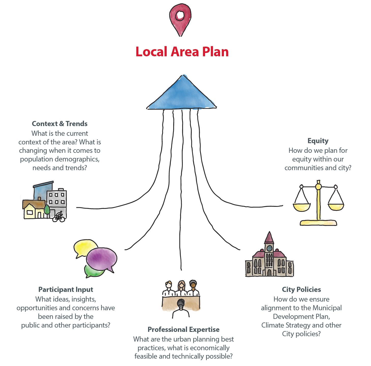
Although it would be a great outcome, the goal of public engagement is not to reach consensus or make everyone happy. Public engagement is about considering the input, ideas and perspectives of those who are interested in or impacted by decisions, before decisions are made. Participant input is an important part of local area planning, but is one of many areas of consideration. Other areas include: City policies, professional expertise, current context and trends, and equity which all factor into the ultimate decision-making process and concept development.
Public input provided in each phase of the engagement process was compiled, reviewed and considered as each chapter of the local area plan was created.

What We Heard & What We Did
FAQs
FREQUENTLY ASKED QUESTIONS
You'll find answers to the most frequently asked questions below. These questions will be updated throughout the project.
Planning Together for the Next 30 Years
We’re working together to create a local area plan for the South Shaganappi Communities including: Banff Trail, Montgomery, Parkdale, Point McKay, Saint Andrews Heights, University Heights, University District, Varsity, and The University of Calgary.
What is a Local Area Plan?
A local area plan sets the vision for the evolution of the area over the next 30 years. It provides direction on future development and investment that residents, landowners, builders / developers, City Planners and Council can commonly refer to when new development and investment ideas are proposed.
Why Do We Need a Local Area Plan?
The city, communities and streets where we live and work have changed, are changing, and will continue to change. People renovate, rebuild, enlarge and modify spaces around them all the time. We need to make sure there’s room for people looking to make changes and provide direction to help guide decisions. We also need to provide guidelines for investment when change is proposed, and certainty for residents and businesses to know how their community may change in the future.
South Shaganappi Communities - Plan Area
The South Shaganappi Communities include Banff Trail, Montgomery, Parkdale, Point McKay, Saint Andrews Heights, University Heights, University District, Varsity, and The University of Calgary.

Conversations about where, why and how revitalization and redevelopment should happen are essential to ensure there's a plan in place to help guide future changes. Growth and change happen in a community with or without a local area plan.
Consumer demand, market forces, and other factors will drive change in the community. However, in areas with high demand that do not have a local area plan, developers will often have to undertake site-by-site land use redesignation / rezoning applications in order to build developments to meet demand for new housing and businesses. This site-by-site approach can create uncertainty for local residents, who don’t know where the next application will come from and what it will propose. It also creates uncertainty for developers, who don’t know for certain what types of proposals will be acceptable where.
A local area plan helps create more certainty for everyone by outlining the general expectation for what scale and type of new development is appropriate where and what policies will help shape development that is proposed.
We are currently in Phase 4 – REALIZE, which is focused on sharing the final draft plan and brining it forward to Committee and Council for review and decision.
In this phase of the project you can review the final draft plan, learn about the key ideas, review the key changes made since the last phase and find an overview of the engagement that took place through the project. The Plan is anticipated to be brought forward to Committee and Council in Winter 2025.

A variety of opportunities for involvement were available through the process that aimed to accommodate a range of participation interests and intensities, as well as to remove barriers to participation.
Engagement opportunities and methods included: working group sessions, in-person and virtual engagement sessions (with the public, community associations and development industry representatives), , online engagement, mailed engagement packages, My Idea Stations, and community walking tours (with community association representatives).
Through the project, advertisements were displayed to help raise awareness of the project and opportunities to get involved. Methods used to raise awareness included: mailed information, community newsletter articles and ads, large format road signs, social media ads (Facebook, X (Twitter), Instagram, Nextdoor), digital ads (including video ads on YouTube), digital ads at local destinations including transit stations, Communications Toolkits for area Councillors and Community Association representatives to help spread the word.
Visit calgary.ca/Shaganappi and check out the "PAST ENGAGEMENT" tab to review What We Heard & What We Did Reports along with Engagement Summaries from each phase through the project.
How was public input considered in the creation of the local area plan?
Input provided by residents and other participants helped the project team understand perspectives, opinions and concerns throughout all phases of the project. Input collected in each phase of the project helped influence and inform the concepts and policies that were created and refined throughout the process. Throughout the project, the project team shared what was heard, highlighted the key themes raised, and provided responses for how key themes were addressed and considered.
Although it would be a great outcome, the goal of public engagement is not to reach consensus or make everyone happy. Public engagement is about considering the input, ideas and perspectives of those who are interested in or impacted by decisions, before decisions are made. Participant input is an important part of local area planning but is one of many areas of consideration. Other areas include: City policies, professional expertise, current context and trends, and equity which all factor into the ultimate decision-making process and concept development.
Visit calgary.ca/Shaganappi and check out the "PAST ENGAGEMENT" tab to review What We Heard & What We Did Reports along with Engagement Summaries from each phase through the project.
Land is not rezoned in connection with the approval or adoption of a local area plan. Landowners determine if and when to propose to rezone their land. If a land use rezoning application were brought forward for a property it would be reviewed for alignment with the local area plan (if approved by Council). If no local area plan or local policy guidance is in place, development proposals are reviewed against other Council-approved City policies including the Municipal Development Plan.
In limited cases, The City (rather than a specific landowner) may propose to rezone land; however, City-initiated land use rezonings are clearly identified as such, prior to being brought forward to Council for decision. City Council is the decision maker on all land use rezoning proposals and a public hearing (which includes opportunities for the public to speak to Council directly) must take place prior to Council decision.
No. While a local area plan identifies and guides where and how future growth and change could happen within a specific area, it is property/landowners who decide if and when redevelopment happens on their property/land. If a property/landowner would like to redevelop their land, they are required to submit a planning application and go through a review process to ensure their application aligns with City policies such as the Municipal Development Plan, Local Area Plan and other applicable City policies
City Council makes the final decision on land use redesignation applications. Administration must review all land use redesignation (rezoning) proposals and makes a recommendation to Council based on planning merits, supporting policy and comments received. Council refers to the local area plan and other City policy and holds a public hearing prior to making a decision. Council can make the final decision on a land use redesignation as outlined in the Municipal Government Act (MGA) based on their own interpretation of policies, site characteristics and the merits of the application.
The City of Calgary does not have jurisdiction over institutions’ lands, including the University of Calgary, Foothills Medical Centre, Alberta Children’s Hospital, and McMahon Stadium. The South Shaganappi Communities Local Area Plan cannot apply future growth policies or direction on this land.
It is anticipated that the South Shaganappi Communities Local Area Plan will be presented to City Council in winter 2025. In the meantime, while the draft Plan is being developed and until Council makes a decision on the proposed Plan, active land use amendment and development permit applications will be reviewed against existing Council approved policy plans, such as the Municipal Development Plan.
In May 2024, Council approved citywide rezoning to allow for single, semi-detached, townhomes and rowhouses across all communities in Calgary. For more information visit calgary.ca/RezoningforHousing. Approved local area plans, those currently underway, as well as all future local area plans will be updated and drafted to align with Council direction to allow for single, semi-detached, townhomes and rowhouses across all communities in Calgary. These changes were effective as of August 6, 2024.
Most mature communities, especially those built prior to 1980, are below their historical peak population, so most communities are already designed to handle more people than live here today. Due to the decline in population and higher efficiency houses being built, there is now infrastructure capacity. This includes roads, transit stops, water and wastewater management, etc. to handle more types of housing.
That being said, through the local area planning process, we plan for reinvestment along with redevelopment. Chapter 3 of the local area plan (Supporting Growth) highlights key community improvements desired within the South Shaganappi Communities. We are looking for feedback on community improvements now to ensure we are capturing all the ways we need to support growth and change in the area.
Those details are not in the scope of a local area plan; however, at the development permit stage details such as building design, site constraints, landscaping, parking, utilities and waste and recycling staging areas are discussed and carefully looked at. Privacy is also discussed as part of the design of the new development. For example, glass blocks or frosted glass can be placed when side windows are proposed. All development permits include the opportunity for the public to provide comments during the review of the proposal as well as to appeal the decision about the proposed development.
Local area plans are meant to be living documents that may be amended and updated over time as the community changes and evolves and as conditions and circumstances in the area change. City Council is the decision maker for all local area plan amendments.
When a local area plan is created, existing area redevelopment plans (ARPs) are reviewed and analyzed. Ideas from ARPs that may still be relevant are considered as the local area plan is drafted. In some cases, policies in older ARPs no longer align with more modern higher-order policies (such as the Municipal Development Plan, etc.) so they cannot be carried over into the local area plan as policy direction must be in alignment.
If a local area plan (also adopted by as an ARP) is approved by Council, existing ARPs within the area are repealed as multiple ARPs cannot be in place for the same area at the same time.


