ECIA Communities Local Area Plan
The ECIA Communities Local Area Plan project has now concluded. For the most up-to-date information, please click the link below.
UPDATES
On December 17, 2024, Council approved the East Calgary International Avenue Communities (ECIA) Local Area Plan with a 14-0 vote
The East Calgary International Avenue Communities Local Area Plan (the Plan) is the result of over two years of engagement with participants including youth, seniors, residents, business owners, community association and development industry representatives, and a dedicated and diverse working group. Feedback provided by participants throughout the process helped shape and refine the Plan that was brought forward to Council. A recording of Council, presentation and attachments can be viewed online here.
The Plan sets out the vision and policies to guide growth, change and investment over the next 30 years in the communities of Albert Park/Radisson Heights, Applewood Park, Dover, Erin Woods, Forest Heights, Forest Lawn, Penbrooke Meadows, Red Carpet, Southview, 09Q and a portion of Golden Triangle. In addition to policies directing how land can be used and redeveloped in the area, the Plan identifies community improvements and investments to support communities as they experience growth and change.
With the approval of the East Calgary International Avenue Communities Local Area Plan, there is now direction on future development, investment and community improvements that residents, landowners, builders/developers, planners and Councillors can commonly refer to when new development and investment ideas are proposed.
The Plan aims to support the area as it evolves by increasing housing options; enhancing mobility choices, enhancing parks, open spaces, recreation and community facilities; build low carbon and climate resilient communities; and support diverse culture, arts and business.
The East Calgary International Avenue Communities Local Area Plan (formerly the Greater Forest Lawn Communities Local Area Plan) first reading was approved by City Council on September 10, 2024, in a unanimous vote. A recording of Committee, presentation and attachments can be viewed online here.
The East Calgary International Avenue Communities Local Area Plan (the Plan) is the result of over two years of engagement with participants including youth, seniors, residents, business owners, community association and development industry representatives, and a dedicated and diverse working group. Feedback provided by participants throughout the process helped shape and refine the Plan that was brought forward to Council.
The Plan sets out the vision and policies to guide growth, change and investment over the next 30 years in the ECIA communities. In addition to policies directing how land can be used and redeveloped in the area, the Plan identifies community improvements and investments to support communities as they experience growth and change.
With the approved first reading of the East Calgary International Avenue Communities Local Area Plan, the Plan will now be submitted to the Calgary Metropolitan Region Board for approval. Council will then follow with a second and third reading of the proposed Plan. After second and third readings by Council, the Plan is expected to become official in early 2025.
Throughout engagement, the Planning team heard interest in changing the name of the “Greater Forest Lawn Communities Local Area Plan” to better reflect the communities included in the Plan area. Public engagement was conducted in Phase 3 to gather feedback for a potential new name for the Local Area Plan document.
As a result, when the proposed Plan is presented to Council for a decision in Fall 2024, it will be recommended that Council approve the name East Calgary International Avenue Communities Local Area Plan as the new Plan name.
To go back to the main page click here: Main Page Link
Plan Overview
Key Ideas
We heard that population growth and providing quality homes that are diverse, accessible and affordable are of utmost importance to the Greater Forest Lawn Communities.
People have different preferences and needs when finding a home (location, price, style, location to amenities or outdoor space). Having a variety of homes to choose from helps people stay in the area as they age, when their needs change and brings new families into the communities.
A variety of small-scale homes, including single detached, semi-detached, rowhouses and townhouses, are supported on any residential lot in the communities. Larger multi-residential homes are strategically concentrated in specific areas including near transit stations, community commercial areas and major roadways such as 36 Street SE and 8 Avenue SE. The Plan balances supporting these diverse housing options while keeping in mind concerns we heard about neighbourhood change.
Increasing housing variety and options helps stabilize and grow a community’s population so that people of all income levels, ages, and cultural backgrounds can have the opportunity to live in the community and support local schools, businesses, services, and amenities.

We heard that residents value the ability to access different types of mobility options within the Greater Forest Lawn Communities. The Plan emphasizes providing a comprehensive mobility network of pathways, transit, roadways and wheeling infrastructures, allowing people more options when moving throughout these communities and beyond. Pedestrian-friendly designs, dedicated cycling lanes, and efficient public transit networks further enhance road safety and provide residents, visitors and workers with safer and more convenient mobility choices.
The Plan seeks to expand the pedestrian and cycling infrastructure network known as Calgary’s Pathway and Bikeway (5A) Network, which is designed to be always available for all ages and abilities. This includes prioritizing walking and wheeling connections, as well as completing missing links to transit station areas, commercial areas, school sites, parks and open spaces, natural areas and community amenities.
The Plan outlines various potential mobility improvements in and around transit stations, along main streets and key corridors, including 17 Avenue SE, 36 Street SE, 34 Avenue SE and 8 Avenue SE, near schools and along regional pathways. These improvements will significantly enhance safety, connectivity and convenience for everyone.

We heard that parks, open spaces, natural and recreation areas, and community facilities are cherished features in the Greater Forest Lawn Communities and the Plan acknowledges the significance of these spaces for current and future residents. These areas are great for events and recreational activities and provide public amenities and space for neighbours to interact with each other to build a stronger sense of community. Parks and open spaces also contribute to the area’s ecological health by providing cooling and shading, wildlife habitat and stormwater retention. Additionally, these spaces help provide a source of mental and physical wellness, a sense of belonging, and general wellbeing for residents and visitors alike.
As the Greater Forest Lawn Communities continue to grow and evolve, it’s important that the parks, open spaces, recreation, and community facilities also evolve and adapt to meet the changing needs of the communities. The Plan aims to protect and invest in accessible, inclusive, and year-round programming in these spaces and facilities for people of all ages, cultural backgrounds, and abilities to promote overall community wellness and quality of life. The Plan identifies various options to support growth objectives, including enhancing existing community amenities such as Elliston Park, Max Bell Centre, and Escarpment Park.
Additionally, the Plan guides the protection, maintenance, and support of the urban tree canopy throughout the communities.

The Greater Forest Lawn Communities are vulnerable to the impact of climate change. As these communities grow and evolve, the risk to the communities becomes more significant, especially with ongoing environmental changes.
Extreme weather events like heat waves, droughts, and heavy rainstorms are becoming more frequent and concerning. Climate adaptation involves taking actions that minimize the adverse effects of climate change on people, businesses, homes, and the environment. The Plan strives to promote community and building designs that prioritize using materials that safeguard community members and minimize damage to buildings, infrastructure, and natural ecosystems.
The Plan aims to help reduce greenhouse gas emissions and energy costs, one of the major contributors to housing unaffordability. To achieve this, the Plan encourages adopting energy-efficient practices, using renewable energy sources such as solar panels, and promoting sustainable modes of transportation (electric vehicles, walking, cycling, and public transit). These measures help to improve air quality and reduce the risks associated with climate change.

We received feedback from residents highlighting the importance of diverse cultures, arts, local shops, and businesses within the communities. Residents also expressed interest in having more cultural expression spaces, including recreation centres, public spaces, and community hubs.
The Plan intends to enhance and promote the vibrancy and cultural diversity of the International Avenue area by providing a concentration of commercial amenities along the Avenue and supporting various arts and culture initiatives, employment opportunities, businesses, restaurants and services catering to different cultural backgrounds. It also allows more flexibility in providing locally focused commercial amenities along community corridors and commercial areas within neighbourhoods.
The Plan also aims to improve existing recreation centres and extend their operating hours. Furthermore, the Plan explores the potential to create a new recreational and multicultural centre within the Greater Forest Lawn communities that can facilitate cultural expression and various activities.

Urban Form & Building Scale Maps
The Urban Form & Building Scale Maps help visualize where and how growth and change could happen in the plan area over the next 30 years and beyond.
The Urban Form and Building Scale Maps are intended to be interpreted together.
- The Urban Form Map details the purpose and general function of different parts of the communities, such as residential, commercial or mixed use.
- The Building Scale Map outlines the general height and massing of buildings.
It's important to remember that change is very gradual and the Local Area Plan itself does not rezone land. It is property/landowners who determine if and when to propose to rezone their land.
A local area plan sets the vision for the evolution of the area—providing direction on future development and investment that residents, landowners, builders / developers, City Planners and Councillors can commonly refer to as new development and investment ideas are proposed.


Right click and select "open image in new tab" to see larger version of each map.
Alternatively, PDF versions can be found in the About the maps tab above.
 |
|
|
|
|
|
|
|
 |
|
 |
|
|
|
|
|
|
|
|
|
|
|
|
|
|
|
| .
|


| Limited (up to 3 storeys)
|
| Low-Modified (up to 4 storeys)
|
| Low (up to 6 storeys)
|
| Mid (up to 12 storeys)
|
| High (up to 26 storeys)
|
| Plan Area Boundary |
| No Building Scale Category |
| . Parks and Open Space |


Key Changes
For additional information about how the Urban Form and Building Scale maps have evolved over time based on input, including public feedback, take a look at the Summary of Map Changes.
Engagement Overview
Together, over a two-year period with thousands of participants, a local area plan for the East Calgary International Avenue Communities was created.
From Winter 2022 – Spring 2024, conversations about where, why and how revitalization and redevelopment should happen took place with a range of participants. Thousands of individuals were involved in the creation of the Plan from youth to seniors, residents and business owners, community association and development industry representatives and a dedicated and diverse working group that provided in-depth insights and feedback throughout.
A variety of opportunities for involvement were available through the process that aimed to accommodate a range of participation interests and intensities, as well as to remove barriers to participation.
Engagement opportunities and methods included: Greater Forest Lawn Communities Working Group sessions, in-person and virtual engagement sessions (with the public, community associations, cultural community groups & development industry representatives), pop-up engagements, online engagement, mailed engagement packages, My Idea Stations and pick up locations, and community walking tours (with community association representatives).
Through the project, over 22 million advertisements were displayed to help raise awareness of the project and opportunities to get involved. Methods used to raise awareness included: mailed information, community newsletter articles and ads, large format road signs including signs translated into Arabic and Vietnamese, social media ads (Facebook, Twitter, Instagram, Nextdoor), digital ads (including video ads on YouTube and transit, registry, fitness and shopping mall screens), digital and Ethnic radio ads on Fairchild (Filipino/Vietnamese) and Windspeaker (English/Blackfoot/Stony Nakoda), Communications Toolkits for area Councillors and Community Association representatives to help spread the word.
Over 53 public engagement events, 14 community association sessions, 9 working group sessions, 7 cultural community sessions, and 4 builder/development industry sessions were held. Online engagement was open for 100 days and over 93,000 engagement booklets were mailed to residents and businesses. Up to date, there were over 2,750 unique instances of direct engagement and over 1,600 comments were shared.
Input provided by residents and other participants helped the project team understand perspectives, opinions and concerns throughout the all phases of the project. Input collected in each phase of the project helped influence and inform the concepts and policies that were created and refined throughout the process. Throughout the project, the project team shared what was heard, highlighted the key themes raised, and provided responses for how key themes were addressed and considered.
Although it would be a great outcome, the goal of public engagement is not to reach consensus or make everyone happy. Public engagement is about considering the input, ideas and perspectives of those who are interested in or impacted by decisions, before decisions are made.
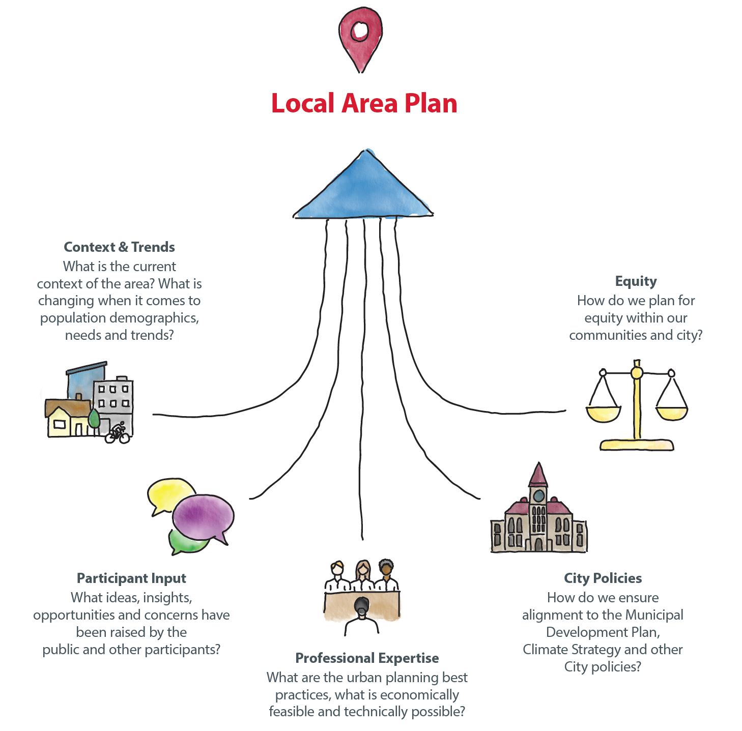
Participant input is an important part of local area planning, but is one of many areas of consideration. Other areas include: City policies, professional expertise, current context and trends, and equity which all factor into the ultimate decision-making process and concept development.
Public input provided in each phase of the engagement process was compiled, reviewed and considered as each chapter of the local area plan was created.


What We Heard & What We Did
FAQs
Frequently Asked Questions
The Greater Forest Lawn Communities are made up of Albert Park/Radisson Heights, Applewood Park, Dover, Erin Woods, Forest Heights, Forest Lawn, Penbrooke Meadows, Red Carpet, Southview, 09Q and a portion of Golden Triangle.
Throughout engagement, the Planning team heard interest in changing the name of the “Greater Forest Lawn Communities Local Area Plan” to better reflect the communities included in the Plan area. Public engagement was conducted in Phase 3 to gather feedback for a potential new name for the Local Area Plan document. As a result, when the proposed Plan is presented to Council for a decision in Fall 2024, it will be recommended that Council approve the name East Calgary International Avenue Communities Local Area Plan as the new Plan name.
A local area plan sets the vision for growth and change in a group of communities over the next 30+ years. A local area plan provides guidance and direction on development and investment that residents, landowners, builders/developers, City Planners and Councillors can commonly refer to when new ideas are proposed for the area.
A local area plan will support your community as it changes by:
- Increasing predictability about how the area could change in the future.
- Responding to changing trends and demographics such as population decline, family composition, aging in place, housing preferences.
- Expanding housing choice to welcome additional people and increase population.
- Supporting local amenities and businesses through increased population.
- Informing decisions about reinvestment such as improvements to public spaces.
- Adding more homes, increasing bikeability, walkability and access to amenities and transit, as well as reducing the need to expand our city’s footprint all play a role in environmental sustainability.
Growth and change happens in a community with or without a local area plan in place. Areas that do not have a local area plan still see site-by-site rezoning and development applications to build developments to meet demand for new housing and businesses.
This site-by-site approach can create uncertainty for local residents, who don’t know where the next application will come and what it will propose. It also creates uncertainty for builders and developers, who don’t know for certain what types of proposals will be acceptable where.
Without a local area plan, conversations about growth and change happen application-by-application, often in a manner disconnected from a wider vision. A local area plan provides a vision for growth and change in an area and helps guide where certain development may be appropriate or not.
While Calgary’s population has been growing approximately 1.8 per cent every year since 1985, the peak population within 86 per cent of Calgary’s established communities has declined.
Population stability within established communities is essential to support local schools, businesses, services and infrastructure. Greater housing choice and diversity supports increased population and stabilization within Calgary’s established communities.

Expanding the types of homes that can be built is a great way to improve housing choice in a community naturally over time – in turn supporting population stability, local schools, businesses, services and infrastructure.
No. New development must always go through the proper permitting and approval process. For proposed development that conforms to existing zoning, developers must submit development permit applications, which detail the design (building height, size, materials, parking, landscaping, etc.) of the proposed development prior to proceeding with construction. The public can view the details of proposed developments, including plans, and can submit comments on proposed developments through the Development Map application (calgary.ca/development). Affected parties can also appeal the approval of a development to the Subdivision and Development Appeal Board.
If a proposed development does not conform to the existing zoning, and a developer wishes to bring the zoning in line with the local area plan, the developer must submit a land use redesignation (rezoning) application. This process is also open to public comment, and similarly to development permits, information is posted on the Development Map application (calgary.ca/development). The decision on a land use redesignation (rezoning) application is made by City Council, and a public hearing is held prior to the decision.
While a local area plan identifies and guides where and how future growth and change could happen within a specific area, it is property/landowners who decide if and when redevelopment happens on their property/land. If a property/landowner would like to redevelop their land, they are required to submit a planning application and go through a review process to ensure their application aligns with City policies such as the Municipal Development Plan, the Local Area Plan and other applicable City policies.
Currently, the Land Use Bylaw permits small-scale homes including single-detached homes to be built up to three storeys; however, specific design details are looked at during the development permit stage. The proposed development should align with the contextual rules set in the Land Use Bylaw. In addition, during the development permit application review, the file manager reviews comments from the public and discusses options with the applicant to better integrate the new proposed development into the existing context.
No. The Plan won’t change land use zoning, but takes a balanced approach to support diverse housing options through policy. A variety of small-scale homes, including single detached, semi-detached, rowhouses and townhouses, are currently supported on any residential lot in the communities. Larger multi-residential homes are strategically concentrated in specific areas including near transit stations, community commercial areas and major roadways such as 36 Street SE and 8 Avenue SE.
We heard that providing quality homes that are diverse, accessible, and affordable is of utmost importance to the Greater Forest Lawn Communities. By expanding housing diversity, people of all income levels, ages, and cultural backgrounds will have the opportunity to live in the community and support local businesses, services, and amenities.
As we refined the plan and finalized the Urban Form and Building Scale maps, our colleagues modelled potential growth scenarios based on the plan to understand how the population of the area can change over time. This model is then used by our transportation and water resources departments to analyze infrastructure capacity and usage based on that expected population growth. This analysis will help identify potential upgrades that may be needed as growth occurs in the Plan Area. This information is also shared with other utility partners, such as Enmax, so they can similarly forecast growth and infrastructure capacity and plan for upgrades.
A key part of the local area plan is recognizing that public infrastructure and amenities need to support growth. Draft Chapter 3: Supporting Growth is dedicated to this issue and outlines the goals and policies that will guide supporting investment and implementation options in the Plan Area as growth and change occurs. Goals such as improving transportation and mobility, improving and expanding playground/park and public spaces, increasing safety and increasing affordable housing are included.
Those details are not in the scope of a local area plan; however, at the development permit stage details such as building design, site constraints, landscaping, parking, utilities and waste and recycling staging areas are discussed and carefully looked at. Privacy is also discussed as part of the design of the new development. For example, glass blocks or frosted glass can be placed when side windows are proposed. All development permits include the opportunity for the public to provide comments during the review of the proposal as well as to appeal the decision about the proposed development.
The draft Plan supports high-quality transit infrastructure that integrates with new development (where feasible) to help reduce vehicle use within the Greater Forest Lawn Communities over time.
Draft Chapter 2 includes policy direction on providing greater flexibility and forms of mobility such as pedestrian, cycling and transit as well as direction on the street network and community improvements were added to draft Chapter 3 to improve mobility connections and prioritize active use and transit investments.
New development will have to address parking considerations mainly by including parking requirements on site that fit the development best and through other measures that can be initiated by the community.
Currently, City Council makes the final decision on land use zoning applications. Administration must review all rezoning proposals and makes a recommendation to Council based on planning merits, supporting policy and comments received. Council refers to the Local Area Plan and other City policy and holds a public hearing prior to making a decision. Council can make a decision based on their own interpretation of policies, site characteristics and the merits of the application.
The Local Area Plan provides high-level policy guidance and a framework for how growth and change could be accommodated in the plan area. The Local Area Plan identifies the urban form categories and building scale modifiers to identify where the different scales of growth and change should occur.
The current Land Use Bylaw outlines the rules and regulations for development of land in Calgary for each district (zone). It also outlines the process for making decisions for development permit applications. The Land Use Districts provide specific rules and requirements such as parking, lot coverage, allowable uses, setbacks and landscaping.
Other policies, guidelines and implementation tools provide further guidance for growth and change in a community.
Input provided by citizens and stakeholders helped the project team understand perspectives, opinions and concerns through all phases of the project. Input collected in each phase of the project helped influence and inform the content, concepts and policies that were created and refined throughout the process. The City ensured background information is provided to help inform input, and the topics and questions that we engaged were influenced or changed based on the input provided.
Throughout the project, the project team shared what was heard, highlighted key themes raised, and provided responses for how key themes would be addressed and considered. You can find What We Heard Reports and What We Did Reports from previous phases of engagement on the project home page at Calgary.ca/GFLplan.
Although it would be a great outcome, the goal of public engagement is not to reach consensus or make everyone happy. Public engagement is about considering the input, ideas and perspectives of those who are interested or impacted by decisions, before decisions are made. Participant input is an important part of local area planning but is only one of many areas of consideration. Other areas include: City policies, professional expertise, current context and trends, and equity, which all factor into the ultimate decision-making process and concept development.
Public input provided in each phase of the engagement process was compiled, reviewed and considered as each chapter of the local area plan was created. Review the Engagement Summary, What We Heard & What We Did reports from each phase of the project for additional detail about what was heard and how input was used.
A variety of opportunities for involvement were available through the process that aimed to accommodate a range of participation interests and intensities, as well as to remove barriers to participation. These included education and engagement booklets mailed directly to all homes and businesses in the area, large format signs in high-traffic areas, geo-targeted social media, banner, and YouTube ads, digital transit ads, an ethnic radio campaign, email updates to project subscribers as well as communication toolkits for local community associations and the local Councillor’s office. Multiple opportunities for in-person and online engagement were offered, in addition to targeted participant sessions.
One of the benefits of housing diversity and choice in a community is that it supports lifelong living as people’s needs change through their lifetime. Housing diversity offers different forms of homes that support the different needs of different people at different stages of their life.
Local area plans are meant to be living documents that may be amended and updated over time as the community changes and evolves and as conditions and circumstances in the area change. City Council is the decision maker for all local area plan amendments.
No. Concerns with landlord and tenant relations are provincial jurisdiction and can be assisted and mediated through the Provincial Government Common problems – Landlords and tenants | Alberta.ca
Crime reduction and safety is a community effort involving many different approaches. Based on public input and ongoing discussions, the project team incorporated safety into the draft vision and core values of the Plan. There is policy in Chapters 2 and 3 to enhance safety in parks, open spaces and public transit and providing direction for buildings and exterior environments to incorporate Crime Prevention Through Environmental Design (CPTED). Chapter 3 also provides policies that can help the GFL communities work with City partners and departments to ensure that the streets are patrolled, and bylaw concerns are addressed including unsightly properties, better maintenance for parks and public spaces, and increased police presence.
Draft Chapter 2 contains policies that outline ways to enhance the redevelopment of parks, open spaces and recreation facilities. It also includes a specific section on trees in Chapter 3, related to new tree planting on public land, in boulevards and Parks, and the protection of existing trees. Chapter 3 also provides objectives and implementation options to upgrade recreational facilities and improve the functionality of existing parks and open spaces by prioritizing accessible, inclusive, and year-round active and passive recreation uses for people of all ages, cultures, and abilities.
On May 14, 2024, City Council voted to approve citywide rezoning with amendments. Additional information will be shared on Calgary.ca/RezoningforHousing as it becomes available.
The East Calgary International Avenue Communities Local Area Plan will be updated to ensure alignment with the citywide rezoning decisions. Specifically:
- Updates to the limited-scale policies are required. Local area plans must align with the rezoning decision and can no longer include policy that limits development to only single-detached or semi-detached homes.
- As a result of this Council direction, policy 2.2.1.6.b and 2.2.1.6.c have will be removed within the proposed version of the Plan that is shared with Committee and Council.
No local area plan map changes are required. No changes to urban form or building scale maps are required as they already align. The lowest urban form category (Neighbourhood Local) combined with the lowest building scale category (Limited) already supports all homes 3 storeys or under.
Next Steps
SHARE YOUR THOUGHTS with Committee and/or Council
The East Calgary International Avenue Communities Local Area Plan was brought forward to Council on September 10, 2024 and for second and third readings on December 17, 2024. You can get involved in public hearings by submitting comments in writing, registering to speak or watching online.
The agenda for meetings will be posted a few days prior to the hearings at the link below:
Those who want to participate in the public hearings can submit their comments or register to speak.
Members of the public may also watch the Committee and Council hearings via live webcastFor more information visit Participate in a Council or Committee meeting (calgary.ca)
ENGAGEMENT FEEDBACK
Did you participate in the Greater Forest Lawn Communities Local Area Planning process? We'd love to hear about your experience and ways that we can improve in the future. Please ensure your feedback is respectful.


