Project Information

Be sure to complete our Survey Below!

Overview

Background:

As our city continues to grow, we are planning infrastructure to accommodate Calgarians in future southwest communities as well as transit and recreational developments. This year we will be conducting a planning study to identify the footprint and type of possible interchange and outline options for the intersection of Macleod Trail and 210 Avenue S. The proposed interchange at 210 Avenue S., is part of the West Macleod Outline Plan application for the development of 215 hectares of land located south of Stoney Trail SW and west of Macleod Trail SW.

About the Study:

This study will compare two types of interchanges at 210 Avenue S., to find the best design to effectively use City-owned land and that allows traffic to flow smoothly. The study will focus on a Diverging Diamond Interchange design and a Partial Cloverleaf design. The interchange design concepts will be technical infrastructure designs with architectural constraints.

Community Involvement:

When we have design concepts prepared, we will connect with Calgarians to share these options. While these technical infrastructure designs come with architectural constraints that limit design input, we are committed to sharing as much information as possible with community members.

Timeline:

We anticipate the planning study to be complete before the end 2025.

Diverging Diamond Design: An image showing a blue design for a Diverging Diamond overlaid on top of 210 ave and macleod tr se. The defining feature of a divergent diamond is that the lanes crisscross as they pass over the lower road. Partial Clover Leaf Design: An image showing a blue design for a partial clover leaf overlaid on top of Macleod Tr and 210 ave. The defining feature of a partial clover leaf are two round ramps that allow traffic to merge onto Macleod.
  • Diverging Diamond

    The Diverging Diamond Interchange (DDI) design differs from traditional diamond interchanges because the two directions of traffic on 210 Avenue would briefly cross to the opposite side of each other over Macleod Trail. This allows more effective traffic flow at the signalized intersections within the interchange and enables left-turning vehicles to proceed without crossing opposing traffic.

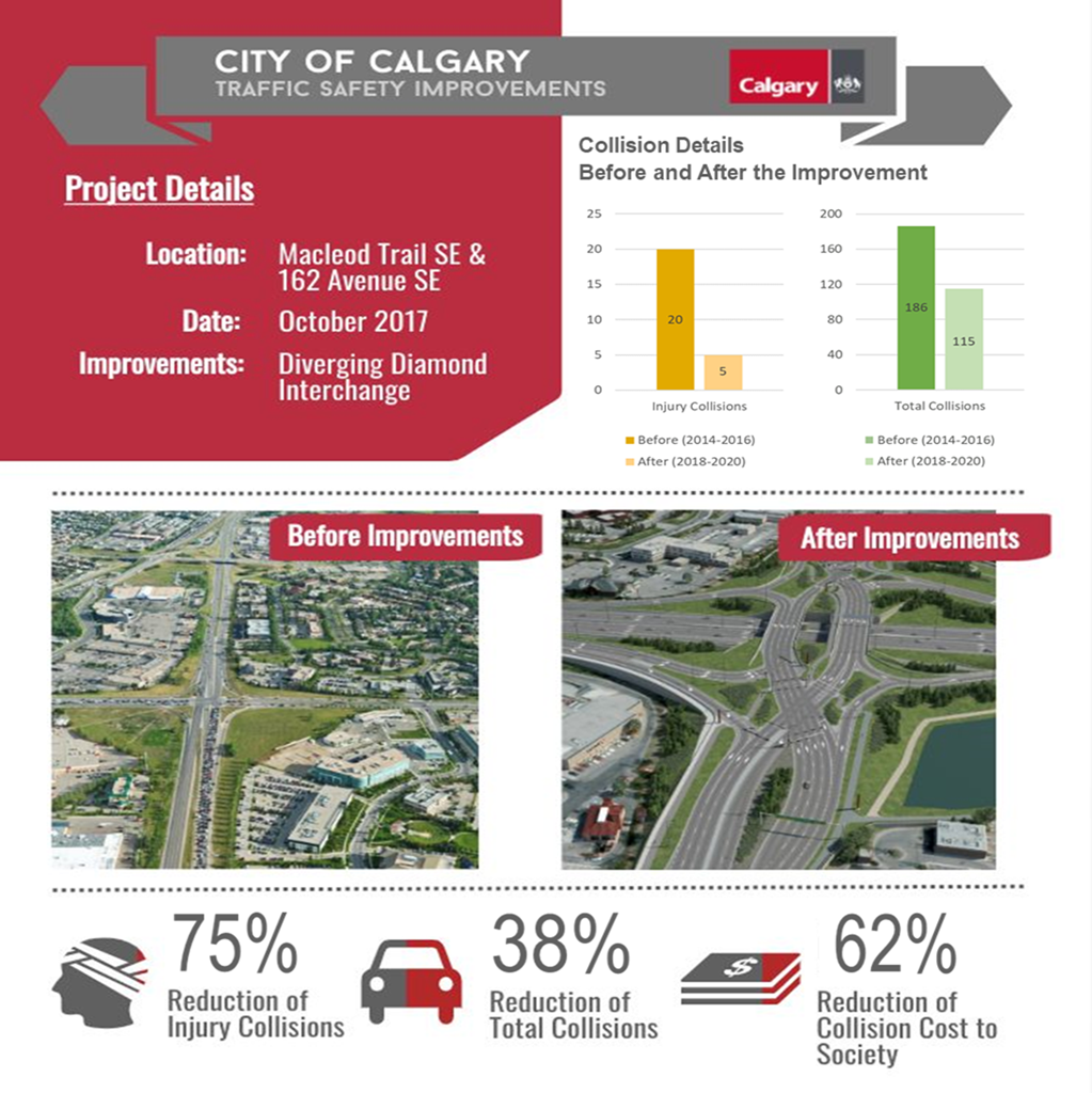
This design significantly reduces delay and improves efficiency compared to a more traditional diamond interchange. Calgary drivers may already be familiar with how a DDI works from the existing DDI at Macleod Trail and 162 Avenue SE, nearby the 210 Avenue study area.

The DDI follows its namesake by “diverging” traffic on the minor street to the left-hand side of the road through two crossover intersections. This enables left-turning traffic to access the major thoroughfare without waiting for a signal or crossing oncoming traffic, nearly halving the number of conflict points compared to a typical diamond interchange.

Right-turning vehicles use slip lanes away from the intersection to bypass the crossovers. With turning movements removed from the crossover intersections, the traffic signals can operate on a short two-phase cycle, improving intersection safety and efficiency. The roadway geometry helps to control vehicle speeds and mitigates potential wrong-way movements, while the wide separation of the bridges helps provide clear visual delineation between the opposing directions of travel.

Advantages

  • Reduced Conflict Points: left-turning traffic accesses the major thoroughfare without waiting for a signal or crossing oncoming traffic.
  • Safety & Efficient: With turning movements removed from the crossover intersections, the traffic signals can operate on a short two-phase cycle compared to three or four phases seen in typical interchange junctions. This improves intersection safety and efficiency.
  • Increased Capacity: for turning movements to and from ramps.
  • Free-flow left-turn movements from 210 Avenue to Macleod Trail northbound and southbound.
  • Enhanced Mobility: Pedestrians and cyclists are uniquely accommodated through DDI by having the pathways converge into a single crossing over Macleod trail. This approach reduces the total number of road and lane crossings as well as reducing the number of high speed crossings, compared to other interchange types.
  • Land impacts and available space for housing development: Reduces overall interchange footprint compared with partial cloverleaf interchange, leaving more space available for housing development.

Disadvantages

  • Vehicle paths crossing go against driver expectations
  • Navigation for active modes is more complex due to pathways converging to a single median pathway across Macleod Trail
  • Partial Clover Leaf

    The partial cloverleaf contains six ramps. On each side of the highway, there is an exit ramp off Macleod Trail, plus a circular loop ramp and a right-turning ramp to enter Macleod Trail. The on-ramps are in the same configuration as a cloverleaf interchange, but there is one off-ramp for each highway direction instead of two, requiring a signalized intersection where the off-ramp meets the arterial road.

All movements from the arterial road to the entrance ramps are made by right-hand turns, providing for a safer entrance to Macleod Trail by eliminating left-hand turns into opposing traffic.

The partial cloverleaf is a very common interchange configuration, with many examples throughout Calgary. A nearby example is Macleod Trail at Shawnessy Blvd.

Advantages

  • Not conducive to wrong-way movements
  • Circular ramps allow traffic to freely enter Macleod Trail without having to make left turns against opposing traffic.

Disadvantages

  • Loop ramps are less efficient than directional ramps due to tight curves
  • Larger overall interchange footprint and land impacts compared with DDI
  • Greater number of high-speed crossings for pedestrians and active modes
  • Less efficient traffic operations due to multi-phase traffic signals

West Macleod Outline Plan

A satellite map of the west macleod area. It shows the Red Line extension moving south from Somerset into Silverado. There is space set aside for an Operation and Workplace Centre, 194 av Bus Facility, the West Macleod Trail Outline Plan, the 210 Ave Inte

The city is planning to divide and develop a large piece of land south of Stoney Trail SW and west of Macleod Trail SW. They will submit their plan to be reviewed by various city departments and committees and City Council before making a final decision.

It will include a variety of uses including:

109.87 hectares - Wetland protection

17.83 hectares - Future regional park

51.23 hectares - Future LRT stations, LRT/bus maintenance and storage facilities, & a city operation centre.

20.77 hectares - mixed-use and residential development

As well as future interchanges at Macleod TR and 194 AV and 210 AV SW.