West Elbow Communities Local Area Plan
The West Elbow Communities Local Area Plan project has now concluded. For the most up-to-date information, please click the link below.
West Elbow Communities Local Area Plan
Approved By Council
On May 7, 2025, Council Approved the West Elbow Communities Local Area Plan, in a 8-5 vote.
Post-Committee Update
- Amend Map 3 entitled “Urban Form” by changing “Industrial General” to “Neighbourhood Flex” with the “Industrial Transition” modifier on 10 Avenue SW west of 19 Street SW, and by deleting the “Industrial General” category from the legend;
- Amend Map 4 entitled “Urban Form” by changing “No Scale Modifier” to “Low-Modified (up to 4 Storeys” on 10 Avenue SW west of Crowchild Trail SW, and “Low (up to 6 Storeys)” on 10 Avenue SW east of Crowchild Trail SW;
- In section 2.2 amend the “Urban Form Categories” graphic to remove the “Industrial” category, including the “Industrial General” portion; and
- Delete section 2.2.3 Industrial, and Figure 5: Industrial Urban Form Categories. This section included Industrial policy, which is no longer required as there are no industrial areas indicated in Map 3 entitled “Urban Form”.
- Delete section 2.5.2.3.e. This policy restricted any shadowing on the north side of a portion of 33 Avenue SW. The amended policy would still minimize shadows, but not restrict them altogether.
Engagement Overview
From September 2023 - February 2025, a range of participants took part in conversations about where, why and how revitalization and redevelopment should happen in the West Elbow Communities.
The West Elbow Local Area Plan was created with input from youth, seniors, residents and business owners, community association and development industry representatives and a dedicated and diverse working group that provided in-depth insights and feedback throughout.
A variety of opportunities for involvement were available through the process that aimed to accommodate a range of participant interests and intensities, as well as to remove barriers to participation.
Engagement opportunities and methods included: working group sessions, in-person and virtual engagement sessions (with the public, community associations and development industry representatives), online engagement, mailed engagement packages, My Idea Stations, and community walking tours (with community association representatives).
Through the project, advertisements were displayed to help raise awareness of the project and opportunities to get involved. Methods used to raise awareness included: mailed information, community newsletter articles and ads, large format road signs, social media ads (Facebook, X (Twitter), Instagram, Nextdoor), digital ads (including video ads on YouTube), digital ads at local destinations including transit stations, Communications Toolkits for area Councillors and Community Association representatives to help spread the word.
Input provided by residents and other participants helped the project team understand perspectives, opinions, and concerns throughout all phases of the project. Input collected in each phase of the project helped influence and inform the concepts and policies that were created and refined throughout the process. Throughout the project, the project team shared what was heard, highlighted the key themes raised, and provided responses for how key themes were addressed and considered.
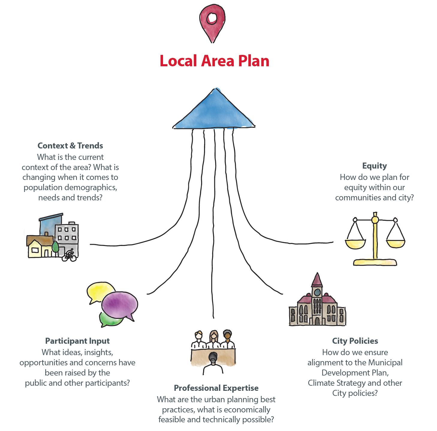
Although it would be a great outcome, the goal of public engagement is not to reach consensus or make everyone happy. Public engagement is about considering the input, ideas, and perspectives of those who are interested in or impacted by decisions, before decisions are made. Participant input is an important part of local area planning, but is one of many areas of consideration. Other areas include: City policies, professional expertise, current context and trends, and equity which all factor into the ultimate decision-making process and concept development.
Public input provided in each phase of the engagement process was compiled, reviewed, and considered as each chapter of the local area plan was created.

What We Heard & What We Did
Proposed Plan (March 2025)
Proposed Plan
The proposed West Elbow Communities Local Area Plan (March 2025 version) sets the vision for the evolution of the area over the next 30 years, including direction on future development and investment in the area.
Proposed West Elbow Communities Local Area Plan
Vision and Key Moves
The West Elbow Communities are a diverse and vibrant set of communities that are defined by their proximity to downtown, walkable neighbourhoods, an exceptional park network highlighted by the Elbow River valley, and unique commercial areas such as 17 Avenue SW and Marda Loop. The West Elbow Communities will continue to grow and develop as well-connected areas that offer a wide range of housing, recreational, and commercial opportunities for both residents and visitors.
 Celebrating the unique histories of the West Elbow Communities
- Finding opportunities to commemorate the histories of the Plan area through educational, placemaking, and naming opportunities, including Indigenous and non-Indigenous histories.
- Incentivizing the retention of historic buildings and places.
- Ensuring new development within heritage-rich areas is contextually sensitive.
 Supporting diverse housing options throughout the Plan area to meet the needs of all
- Supporting a diversity of housing options that meet the current and evolving needs of Calgarians today and in the future.
- Enabling the provision of mixed-market housing and non-market housing.
 Enhancing and expanding the open space system throughout the Plan area
- Enhancing natural areas, like the Elbow River valley, to improve ecological functions and protect areas of cultural significance.
- Identifying park improvements and investment opportunities in existing parks including Lindsay Park, South Calgary Park, and community parks throughout the Plan area.
- Supporting improvements to recreational facilities including the MNP Community & Sport Centre and Glenmore Athletic Park.
 Improving the safety and accessibility of all mobility options to and through the Plan area
- Highlighting opportunities to improve pedestrian and active mobility modes including community corridor and pathway improvements.
- Supporting improvements to the transit network through identifying opportunities for mobility infrastructure upgrades, including transit station area improvements near Sunalta LRT Station and Erlton/Stampede LRT Station as well as around BRT stations.
 Identifying mitigation measures that address hazards caused by a changing climate
- Supporting sustainable development practices that limit per capita greenhouse gas emissions.
- Identifying opportunities to reduce vulnerability from climate events such as flooding.
 Enabling a diversity of businesses throughout the Plan area and improving access to daily needs and amenities
- Highlighting opportunities for Main Street improvements throughout the Plan area including 10 Avenue SW, 17 Avenue SW, 33 Avenue SW, Macleod Trail S, 4 Street SW, and 14 Street SW.
- Exploring opportunities for local commercial uses along community corridors and within select communities like Bankview, Sunalta, South Calgary, Mission, and Cliff Bungalow.
Learn more about the key aspects of the Plan and how to read the Plan in the new Executive Summary (pages 6 to 16) of the proposed Plan.
PROPOSED PLAN UPDATES
The final draft Plan, shared in January 2025 has been updated and is now known as the proposed Plan. The Summary of Updates in the proposed Plan provides an overview of the updates that have been made. These include:
- the addition of an Executive Summary
- a core values map illustration
- mapping and clerical updates
- new Chapter 3 illustrations
- a supplementary Heritage Guidelines Implementation Guide
- removal of references to the Calgary Metropolitan Regional Board Growth Plan
Updated Proposed Maps
The Building Scale Map and Urban Form Map have been updated slightly from the final draft version to the proposed version. The updated maps can be viewed below and by clicking the links above. The updated maps are also in the proposed Plan.


Share Your Thoughts with Committee
Committee Date
The proposed Plan will be brought forward to the Infrastructure and Planning Committee (IPC) for review and decision on Wednesday, April 2, 2025. Following IPC, the Public Hearing Meeting of Council is tentatively scheduled for Tuesday, May 6, 2025.
Public Submissions
Anyone who is interested can participate in the public hearing of Committee and/or Council. You can submit your comments in writing, register to speak or watch proceedings online.
Submissions should clearly state that the comment is for the "West Elbow Communities Local Area Plan". The deadline to have your public submission added to the agenda for IPC is March 26, 2025 (one week before the April 2, 2025 Committee date).
- Public Submission to City Clerks – select “Request to speak” or “Submit a comment”
- Council and Committee webcasts
- Council and Committee Agendas, Minutes and Video
Watch Committee and Council hearings via live webcast:
Public Hearing Process
If you are interested in submitting comments or speaking at Committee, please visit calgary.ca/PublicHearing to learn more about the process. The following videos and tip sheets provide a summary of some of the key things to know:
- How do I Participate in a Public Hearing
- Tips for Submitting a Comment or Presenting
- Public Hearing Tip Sheet
- Public Submissions Tip Sheet
- Accessibility and inclusion services
The agendas will be posted a few days prior to the hearings at the link below:
Final Draft Plan (January 2025)
Final Draft Plan
NOTE: The final draft Plan and information below was shared through the Phase 4 of the project in January 2025. To see the updated version of the Plan that will be taken to Committee for review and decision on April 2, please review the proposed Plan (March 2025) version under the "Proposed Plan" tab.
The final draft West Elbow Communities Local Area Plan (LAP) sets the vision for the evolution of the area over the next 30 years—providing direction on future development and investment that residents, landowners, builders/developers, City Planners and Councillors can commonly refer to as new development and investment ideas are proposed.
Final Draft West Elbow Communities Local Area Plan
KEY IDEAS

We heard about the importance of the unique histories that define the West Elbow Communities, which include some of the city’s oldest communities as well as historic indigenous gathering places and sites of significance. The Plan recognizes the significance of acknowledging and honouring important pieces of history that made the West Elbow Communities what they are today.
The Plan identifies and highlights cultural landscapes within parks and other public spaces by seeking unique placemaking opportunities to allow for historic storytelling and supporting gathering spaces for arts and cultural performances.
Heritage Guidelines are included in the Plan to recognize areas with concentrations of heritage assets, commonly known as character homes, built before 1945. Within the West Elbow Communities, Heritage Guideline Areas include portions of the communities of Bankview, Cliff Bungalow, Elbow Park, Lower Mount Royal, Mission, Roxboro, Rideau Park, Scarboro, South Calgary, Sunalta, and Upper Mount Royal. We heard about the importance of ensuring new developments are sensitive to and respect existing historic homes. Heritage Guideline policies require new development, including multi-residential developments, to be contextually sensitive and fit the historic fabric of surrounding heritage assets.

We heard from people that they value parks, open spaces, recreational facilities and natural areas, such as the Elbow River Valley. These spaces provide opportunities to recreate and gather, contributing to mental and physical health, a sense of belonging and general wellness. They also perform important ecological functions such as greening the city, providing habitat and managing stormwater.
The Plan identifies protection and improvements to ecologically sensitive areas, such as the Elbow River Valley. It provides recommendations for improving and better connecting natural areas, along with expanding the tree canopy throughout the West Elbow Communities.
The Plan seeks opportunities to upgrade existing parks through methods such as providing multi-functional spaces to better serve the surrounding community. Additionally, the Plan supports new civic facilities and community spaces that support all ages, abilities and incomes.
The Plan also identifies enhancement to safety and accessibility of parks and open spaces through enhanced pedestrian crossings, connecting missing links in the sidewalk and pathway networks, improved lighting, signage and wayfinding.

Participants value the range of mobility options in the West Elbow Communities, such as public transit, the cycling and pedestrian networks, including pathways along the Elbow River, and large vehicle routes including Crowchild Trail SW.
The Plan strives to improve and expand walking and cycling infrastructure throughout the Plan area, including enhancing connections between transit station areas, Main Streets, community corridors, schools, parks and natural areas.
The Plan also seeks to enhance transit priority measures throughout the Plan area to meet Primary Transit Network criteria of a faster and more reliable network. Additionally, the Plan emphasizes improvements to transit station areas to strengthen connections to surrounding destinations, better accommodate cycling and pedestrian connections and improve accessibility and safety.
As growth and change continue to occur, the Plan supports improvements to east-west mobility options to better connect key parts of the West Elbow Communities and other destinations beyond the Plan area.

Participants identified the importance of having diverse housing options within the West Elbow Communities. Expanding housing diversity will allow more people to live in the area, help current residents to stay in the area as their needs change, and support businesses, transit, schools, services, and amenities. The Plan focuses on finding opportunities to provide and enable inclusive, diverse and equitable housing options across the Plan area.
Additionally, the Plan recognizes that there is opportunity in and around transit station areas, including Sunalta and Erlton LRT stations and MAX BRT stations, to accommodate more housing. Higher density development within proximity to transit stations also supports public transit ridership and transit-oriented development.
The Plan also considers housing that is affordable for various demographics by encouraging the development of housing, including non-market, mixed-market, multigenerational, and cohousing options. Ensuring that housing is accessible and meets the evolving needs of people is crucial as the West Elbow Communities experience growth and change.

We heard that the West Elbow Communities are some of the most walkable areas in Calgary. Residents value the proximity of shops and services on Main Streets such as 4 Street SW, 17 Avenue SW and 33 Avenue SW as well as services and amenities along 14 Street SW, 10 Avenue SW and Macleod Trail S. Improving pedestrian and cycling access to these daily amenities, while providing neighbourhood gathering spaces, can help support these important parts of the West Elbow Communities.
The Plan emphasizes improving public space around community commercial amenities, particularly around Main Streets and community corridors. The Plan explores improving pedestrian and cycling conditions at crossings of major roads and bridges and providing traffic calming measures that reduce traffic and shortcutting through residential streets, particularly near Main Streets, transit station areas and other streets with high traffic volumes.
The Plan also looks at opportunities for providing additional public space, seating areas, local parks and plazas on public space adjacent to community commercial areas.
LOCAL AREA PLAN MAPS
The Urban Form & Building Scale Maps help visualize where and how growth and change could happen in the plan area over the next 30 years and beyond.
The Urban Form and Building Scale Maps are intended to be interpreted together.
- The Urban Form Map shows types of buildings and what they should be used for. These can include primarily commercial/business areas, primarily residential areas and parks and open space.
- The Building Scale Map shows the maximum height and size buildings can be in a specific area. Scale categories contain policies that outline building heights and other design considerations such as stepbacks (where higher floors are setback from lower floors).
Additional details on the categories within these maps can be found in sections 2.2 and 2.3 of the West Elbow Communities Local Area Plan or within the Visual Legend.
It's important to remember that change is very gradual and the Local Area Plan itself does not rezone land. It is property/landowners who determine if and when to propose to rezone their land.
A local area plan sets the vision for the evolution of the area—providing direction on future development and investment that residents, landowners, builders / developers, City Planners and Councillors can commonly refer to as new development and investment ideas are proposed.
Move the slider to see both the Urban Form Map and the Building Scale Map. Alternatively, click on the relevant link to view the maps in PDF.


URBAN FORM CATEGORIES AND BUILDING SCALE MODIFIERS
Below is a high-level overview of all urban form categories that are available to guide intended building forms within a given area. Urban form categories do not address the proposed height of built forms as these are identified through the Building Scale Map.
Building scale refers to the combination of height and building mass that influences the experience on the ground floor.


SUMMARY OF MAP CHANGES
For additional information about how the Urban Form and Building Scale maps have evolved over time based on input, including public feedback, take a look at the Summary of Map Changes.
FAQs
You'll find answers to the most frequently asked questions here. These FAQs will be updated throughout the project.
Planning Together for the Next 30 Years
We’re working together to create a local area plan for Altadore, Bankview, Cliff Bungalow, Elbow Park, Erlton, Garrison Woods, Lower Mount Royal, Mission, North Glenmore Park (north of Glenmore Trail SW), Richmond (east of Crowchild Trail SW), Rideau Park, Roxboro, Scarboro (east of Crowchild Trail SW), South Calgary, Sunalta, and Upper Mount Royal.
What is a Local Area Plan?
A local area plan sets the vision for the evolution of the area over the next 30 years. It provides direction on future development and investment that residents, landowners, builders / developers, City Planners and Council can commonly refer to when new development and investment ideas are proposed.
Why Do We Need a Local Area Plan?
The city, communities and streets where we live and work have changed, are changing, and will continue to change. People renovate, rebuild, enlarge and modify spaces around them all the time. We need to make sure there’s room for people looking to make changes and provide direction to help guide decisions. We also need to provide guidelines for investment when change is proposed, and certainty for residents and businesses to know how their community may change in the future.
Conversations about where, why and how revitalization and redevelopment should happen are essential to ensure there's a plan in place to help guide future changes. Growth and change happen in a community with or without a local area plan.
Consumer demand, market forces, and other factors will drive change in the community. However, in areas with high demand that do not have a local area plan, developers will often have to undertake site-by-site land use redesignation / rezoning applications in order to build developments to meet demand for new housing and businesses. This site-by-site approach can create uncertainty for local residents, who don’t know where the next application will come from and what it will propose. It also creates uncertainty for developers, who don’t know for certain what types of proposals will be acceptable where.
A local area plan helps create more certainty for everyone by outlining the general expectation for what scale and type of new development is appropriate where and what policies will help shape development that is proposed.
We are currently in Phase 4 – REALIZE, which is focused on sharing the final draft plan and brining it forward to Committee and Council for review and decision.
In this phase of the project you can review the final draft plan, learn about the key ideas, review the key changes made since the last phase and find an overview of the engagement that took place through the project. The Plan is anticipated to be brought forward to Committee and Council in Spring 2025.
A variety of opportunities for involvement were available through the process that aimed to accommodate a range of participant interests and participation intensities, as well as to remove barriers to participation.
Engagement opportunities and methods included: working group sessions, in-person and virtual engagement sessions (with the public, community associations and development industry representatives), online engagement, mailed engagement packages, Engagement Stations, and community walking tours (with community association representatives).
Through the project, advertisements were displayed to help raise awareness of the project and opportunities to get involved. Methods used to raise awareness included: mailed information, community newsletter articles and ads, large format road signs, social media ads (Facebook, X (Twitter), Instagram, Nextdoor), digital ads (including video ads on YouTube), digital ads at local destinations including transit stations, Communications Toolkits for area Councillors and Community Association representatives to help spread the word.
Check out the "PAST ENGAGEMENT" tab to review What We Heard & What We Did Reports along with Engagement Summaries from each phase through the project.
Input provided by residents and other participants helped the project team understand perspectives, opinions and concerns throughout all phases of the project. Input collected in each phase of the project helped influence and inform the concepts and policies that were created and refined throughout the process. Throughout the project, the project team shared what was heard, highlighted the key themes raised, and provided responses for how key themes were addressed and considered.
Although it would be a great outcome, the goal of public engagement is not to reach consensus or make everyone happy. Public engagement is about considering the input, ideas and perspectives of those who are interested in or impacted by decisions, before decisions are made. Participant input is an important part of local area planning but is one of many areas of consideration. Other areas include: City policies, professional expertise, current context and trends, and equity which all factor into the ultimate decision-making process and concept development.
Check out the "PAST ENGAGEMENT" tab to review What We Heard & What We Did Reports along with Engagement Summaries from each phase through the project.
Land is not rezoned in connection with the approval or adoption of a local area plan. Landowners determine if and when to propose to rezone their land. If a land use rezoning application were brought forward for a property it would be reviewed for alignment with the local area plan (if approved by Council). If no local area plan or local policy guidance is in place, development proposals are reviewed against other Council-approved City policies including the Municipal Development Plan.
In limited cases, The City (rather than a specific landowner) may propose to rezone land; however, City-initiated land use rezonings are clearly identified as such, prior to being brought forward to Council for decision. City Council is the decision maker on all land use rezoning proposals and a public hearing (which includes opportunities for the public to speak to Council directly) must take place prior to Council decision.
No. While a local area plan identifies and guides where and how future growth and change could happen within a specific area, it is property/landowners who decide if and when redevelopment happens on their property/land. If a property/landowner would like to redevelop their land, they are required to submit a planning application and go through a review process to ensure their application aligns with City policies such as the Municipal Development Plan, Local Area Plan and other applicable City policies.
City Council makes the final decision on land use redesignation applications. Administration must review all land use redesignation (rezoning) proposals and makes a recommendation to Council based on planning merits, supporting policy and comments received. Council refers to the local area plan and other City policy and holds a public hearing prior to making a decision. Council can make the final decision on a land use redesignation as outlined in the Municipal Government Act (MGA) based on their own interpretation of policies, site characteristics and the merits of the application.
It is anticipated that the West Elbow Communities Local Area Plan will be presented to City Council in Spring 2025. In the meantime, while the draft Plan is being developed and until Council makes a decision on the proposed Plan, active land use amendment and development permit applications will be reviewed against existing Council approved policy plans, such as the Municipal Development Plan.
In May 2024, Council approved citywide rezoning to allow for single, semi-detached, townhomes and rowhouses across all communities in Calgary. For more information visit calgary.ca/RezoningforHousing. Approved local area plans, those currently underway, as well as all future local area plans will be updated and drafted to align with Council direction to allow for single, semi-detached, townhomes and rowhouses across all communities in Calgary. These changes were effective as of August 6, 2024.
Most mature communities, especially those built prior to 1980, are below their historical peak population, so most communities are already designed to handle more people than live here today. Due to the decline in population and higher efficiency houses being built, there is now infrastructure capacity. This includes roads, transit stops, water and wastewater management, etc. to handle more types of housing.
That being said, through the local area planning process, we plan for reinvestment along with redevelopment. Chapter 3 of the local area plan (Supporting Growth) highlights key community improvements desired within the West Elbow Communities. We are looking for feedback on community improvements now to ensure we are capturing all the ways we need to support growth and change in the area.
Those details are not in the scope of a local area plan; however, at the development permit stage details such as building design, site constraints, landscaping, parking, utilities and waste and recycling staging areas are discussed and carefully looked at. Privacy is also discussed as part of the design of the new development. For example, glass blocks or frosted glass can be placed when side windows are proposed. All development permits include the opportunity for the public to provide comments during the review of the proposal as well as to appeal the decision about the proposed development.
Local area plans are meant to be living documents that may be amended and updated over time as the community changes and evolves and as conditions and circumstances in the area change. City Council is the decision maker for all local area plan amendments.
A local area plan sets the vision for growth and change in a group of communities and takes into considerations the need to balance population across both new and established communities.
As Calgary continues to grow and evolve, the number of school-age children in each community changes. This means some schools may meet or exceed their capacity. As a result, some schools may be expanded or modernized to meet demand, while others may face decreasing enrolment.
The City works with the public and Catholic school boards to provide information such as: demographic composition of new and established communities, community growth/decline rates, birth data, and census data, which can help with capacity and school utilization planning.
We are currently preparing the final draft Heritage Guidelines Implementation Guide. Subscribe to this Guide-specific mailing list to be notified once it's available.


