About the project
This study aimed to address short and long-term infrastructure needs in West Calgary through potential road, pathway, and intersection improvements, focusing on network connectivity for all users in the area.
Thank you for participating!
Engagement and the functional planning study are now complete! For project updates visit:
Following Phase 3 engagement, the recommended plan for the Sarcee Trail/Bow Trail S.W. Functional Planning Study is now ready to be shared. To view the entire recommended plan see the Phase 3: Reveal tab on this page.
How we used feedback to shape the recommended plan:
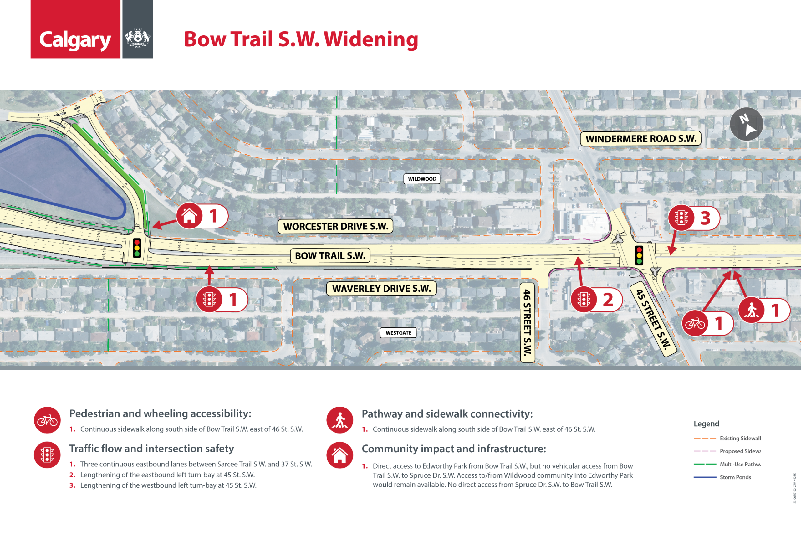
During all three phases of engagement, people told us that safer, easier connections for pedestrians and wheeling users are a priority. The plan adds new pedestrian and wheeling connections under Bow Trail and Sarcee Trail S.W and improves sidewalk connections along Bow Trail S.W. This will make it easier to move through the intersection and along the corridors.
Throughout engagement, interest-holders emphasized the need to improve traffic flow while increasing safety at the intersection and along the corridors. The plan proposes a new interchange design that allows traffic to move more smoothly and safely. Bow Trail S.W. would also be widened to three lanes to further improve traffic flow.
Feedback highlighted the importance of maintaining public access to Edworthy Park while minimizing impacts to the Edworthy Park Off-Leash Area. The proposed plan introduces new access points to Edworthy Park, making it easier for Calgarians to visit the park without travelling through the Wildwood community, while still maintaining access for local traffic. The plan also integrates with the existing pathway network, supporting safe and convenient connections for pedestrians and wheeling users. The intersection design minimizes impacts to green space and surrounding communities, and no land acquisition is required for this part of the project.
Updates to the recommended plan:
Click the coloured dot on the map to view a zoomed‑in look at the intersection and learn what has changed since Phase 3.
Next steps
Detailed design
The recommended plan developed during the functional planning study process will move into detailed design, followed by construction when funding becomes available.
During the detailed design phase, the recommended plan will continue to be refined and evolve. This phase will transform the recommended plan into a detailed construction plan and may appear different from the recommended plan due to design standards, market variations or technical constraints identified during the detailed design phase.
Construction phasing
Due to the scope and complexity of the project, the recommended plan would be implemented in four phases:
- Edworthy Park connection - Bow Trail S.W. to Spruce Drive S.W.
- Bow Trail S.W. widening
- Sarcee Trail/ Bow Trail S.W. interchange
- Sarcee Trail S.W. widening
Funding
The project will be seeking funding in the upcoming 2027-30 budget cycle. In its 4 phases, the project is estimated to cost $336.5 million.
Past engagement phases
Project Background
Project background
In 2012, City Council approved the West Springs Area Structure Plan (ASP), an initiative that directly impacts the infrastructure within the study area. The Plan explores ways to enhance safety within the ASP and to improve traffic flow at the intersection and corridors in the surrounding area, including the possible expansion of both the Sarcee Trail and Bow Trail corridors.
This study
Currently, our focus is conducting a functional planning study to validate the recommendations made in the ASP. This study is an important step in ensuring that the supporting infrastructure aligns with the ASP development and the community's needs and priorities.
In previous years, The City has implemented improvements to help mitigate issues such as traffic congestion and safety in the area. This includes the 2022 construction of a U-Turn lane on the east leg of the Bow Trail S.W. and Sarcee Trail S.W. intersection. This functional planning study is the next step in planning for long-term solutions.
The study aims to address short and long-term infrastructure needs in West Calgary through potential road, pathway, and intersection improvements, focusing on network connectivity for all users of the area.
Study goals:
- Exploring the feasibility of intersection and roadway improvements along Sarcee Trail S.W. and Bow Trail S.W.
- Upgrading pathways to improve safety, accessibility, and connectivity for everyone in the area.
- Determining preferred interchange options that integrate with the adjacent neighborhoods and the S.W. roadway network.
- Reviewing the traffic volumes at the intersection of Bow Trail and Old Banff Coach Road S.W., to determine if land previously reserved for a potential interchange is still necessary.
Study area maps and design constraints

Click on map to zoom in


Existing constraints in the study area will be taken into consideration when developing concept options and selecting a preferred plan for the interchange and corridor upgrades, including:
- Major utilities within the study area will need to be incorporated in the design or potentially moved to accommodate the new or upgraded infrastructure.
- The interchange design may require the temporary access road (Strathcona Hill S.W.) to be closed at Bow Trail S.W to accommodate the new infrastructure.
Public engagement process
From Spring 2024 to Winter 2025 we will be engaging with interest holders and the public to gather feedback to develop design concepts, and a preferred plan for the study area.
The engagement process for the study will be conducted in three phases:
How your feedback will be used
Public input is essential for creating a functional plan that aligns with community needs. However, technical data, policies, budgets, and best practices will also inform the plan.

Reporting back
In Fall 2024, we’ll share a report summarizing the feedback we received during Phase 1: Discover. This report will inform the project team’s work to prepare for Phase 2: Explore, where we will share design concept options for public feedback.
For each project phase, we’ll create a dedicated “What We Heard” report, ensuring that we build on insights from one phase to the next. Through our reporting process we will also share how public input influenced the design concept options and the preferred plan.
Project funding
It is important to note that this project did not receive any construction funding in The City’s 2023-2026 Service Plans and Budgets.
Phase 3: Reveal
In Summer 2025, The City shared the recommended plan to improve to the the Sarcee Trail and Bow Trail intersection and corridors. We asked for public feedback on the plan to help the project team make any refinements before finalizing the plan.
What we heard summary
High-level themes of what we heard throughout the engagement process


![]()
The detailed What We Heard Reports can be found in the Engagement Reports section on this page.
Next steps
We are currently incorporating feedback from Phase 3 along with final refinements into the recommended plan. The final plan will be shared in the fall. It will be posted on this webpage and sent through the project newsletter.
To stay informed and receive updates, you can subscribe here.
During this phase of engagement, you can:
- Learn how we got here by reviewing what we heard during previous phases of engagement
- View the recommended plan
- Learn how community feedback helped shape the recommended plan
- Provide your feedback on the recommended plan
- Learn about next steps
How we used feedback to shape the recommended plan

Click below to explore the cross-sections for Sarcee Trail S.W and Bow Trail S.W, as well as the recommended pedestrian improvements to the Sarcee Trail S.W/Bow Trail S.W. intersection.
Bow Trail S.W and Sarcee Trail S.W. cross sections


Bow Trail S.W. improvements
Click below to learn about the recommended changes to the Bow Trail S.W. corridor, 45 Street intersection and the Edworthy Park access from Bow Trail.


How feedback will be used and next steps
Public input is essential for creating a functional plan that aligns with community needs. However, technical data, policies, budgets and best practices will also inform the plan.
- The feedback you provide here today will be used to help refine the recommended plan. The final plan will be posted online and shared via our email newsletter. Subscribe to get updates here.
- The project is not currently funded for detailed design or construction. We do not know when construction funding will be approved.
What happens when funding is approved
If construction funding is approved in the future, the project would proceed through the following steps:
- Detailed design: once construction funds are approved, the approved plan enters the preliminary and detailed design development phase, which includes developing detailed plans and construction.
- Construction: a contractor is engaged, and construction begins once construction funds are approved.
Phase 2: Explore
Phase 2: Explore
In Fall 2024, The City shared three design concept options to improve to the the Sarcee Trail and Bow Trail intersection and corridors. We asked for public feedback on the concept options, to help shape the final plan, which will be shared in Spring 2025. The Phase 2 "What We Heard Report" is now available. Click the link or visit the Document Library for a detailed summary of feedback.
In Spring 2024, we conducted Phase 1 engagement. In Phase 1: Discover, we heard:
- Community desire to improve pedestrian and wheeling accessibility and connectivity in the area with requests for accessible ramps and connections.
- The importance of environmental and green space conservation.
- The need to improve traffic flow and intersection safety within the study area.
- Support to keep the temporary access road open. (Strathcona Hill S.W.)
You can view the full Phase 1 What We Heard report here.
During Phase 2 you can
- Review what we heard during Phase 1 engagement.
- Review and provide your feedback on the concept options.
- Ask the project team questions.
- Learn about next steps.
- View concept options and provide your feedback below.

Design Considerations:
Opening of the West Calgary Ring Road & Traffic Volumes
Following the opening of the West Calgary Ring Road, there was a large decrease in traffic volumes to, from and along Sarcee Tr S.W. Overall volumes at the intersection decreased by 24-30% during peak hours.
The most significant traffic decreases:
- Northbound and southbound through movements on Sarcee Tr S.W.
- Right turn from southbound Sarcee Tr to westbound Bow Tr S.W.
- Left turn from eastbound Bow Tr to northbound Sarcee Tr S.W.
Future Traffic Volumes:
- Expected to be higher than they were before the ring road opened due to growth and development in the area.
- Expected increased eastbound traffic on Bow Tr S.W. means that eastbound Bow Tr S.W. needs to be widened to 3 lanes.
- The project team looked at expected volumes for Bow Tr S.W. and Old Banff Coach Road S.W. intersection. Expected growth in the area and outside Calgary led to the recommendation that The City continues monitoring traffic volumes and reserving land around the intersection for a possible future interchange.
Evaluation Criteria:
We are evaluating the interchange options against criteria that consider the multi-modal improvements and the impact of implementing those improvements. Some of the criteria includes:
- Improved walking and wheeling connections
- Improved safety
- Vehicle operational/capacity improvements to accommodate future growth
- Maintaining or improving community access
- Minimizing impacts to private property
- Minimizing impacts to green spaces
PROVIDE YOUR INPUT

Click to enlarge

Click to enlarge

Click to enlarge

Click to enlarge

Click to enlarge

Click to enlarge

Click to enlarge

Click to enlarge
The rendering images below have been prepared for Interchange Option B and show our initial ideas for the Partial Cloverleaf design. Please note that these are early drafts meant to give you a general idea of what we’re planning. They are for illustration purposes only and will change as we continue to develop the project.
Image 1 of 9


Phase 1: Discover
Phase 1: Discover

During Phase 1 engagement, high-level themes that we heard included the desire to improve pedestrian and wheeling accessibility and connectivity, the importance of environmental and green space conservation and the need to improve traffic flow and intersection safety within the study area.
Find the detailed report in the Document Library on this page.


