Project Update
The City of Calgary and Rocky View County have placed work on the proposed annexation on hold, pending the outcome of the Prairie Economic Gateway Initiative.
For more information on the initiative, please visit:
FAQ
The City of Calgary and Rocky View County are collaboratively exploring opportunities for the joint development potential of industrial lands along Calgary’s southeast boundary. There is potential for stronger development outcomes for both municipalities and the Calgary Metropolitan Region.
This cooperative approach has the potential to create a wealth of economic development opportunities that will benefit landowners, municipalities and the region.
The growth of logistics centres, shipping hubs, manufacturing facilities, film production, and a variety of other industries remains a priority in the Calgary Metropolitan Region.
The annexation process is currently on hold as we explore this collaborative approach to developing the industrial growth corridor.
Engagement with citizens and area landowners is anticipated to occur throughout the process.
The City maintains its website, calgary.ca/rvc, where we will post project updates. We invite you to also subscribe to our email list, which can be found on the website. Periodically, we will also mail letters to landowners and area residents within a 1.6 KM radius of the proposed annexation area.
About the Project
In September 2021, City Council unanimously agreed to proceed with plans to initiate the annexation process for land currently within Rocky View County.
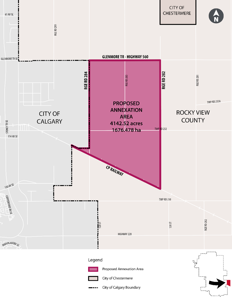
City Administration submitted a formal letter of initiation to begin the annexation process to acquire industrial lands within the boundaries of:
- North: Highway 560
- East: Range Road 282
- South: Canadian Pacific Railway line
- West: Range Road 284
The letter sent to the Land and Property Rights Tribunal fulfills the requirements of Section 116 of the Municipal Government Act.
We are planning for Calgary’s industrial future and this area will ensure we maintain an adequate long-term land supply to accommodate the evolving needs of industrial developers. These lands represent 1,676 hectares of space that aligns with The City’s future growth plans for the industrial sector of Calgary. The Next Generation Planning strategy is creating new ways of planning that support growth and change in Calgary now, and for the next generation.
The proposed annexation area was first identified as future-development land for The City in 2006, with a jointly-approved Rocky View – Calgary Intermunicipal Development Plan formalized in 2007. When annexed, the lands would be developed under The City’s jurisdiction.
Letters to notify our intent have been sent to landowners within the proposed annexation area, as well as those within 1.6 km of the area, as part of the process. Landowners and the general public will have an opportunity to provide input through a series of open houses (or other means depending on public health measures at the time) that will be held in 2022.
Proposed Annexation Area