Phase 3 reveal available
Phase 2 was open for input from April 4-28, 2025. Please click the link below for the most up to date project information.
About the Project
We're developing pathway and bikeway routes in Falconridge, Castleridge, Taradale, Saddle Ridge and Martindale, aligning with Calgary's established Pathway and Bikeway Network. These routes will focus on connections that serve students, recreation, shopping, and work destinations. When built, these routes will provide safe, healthy, and affordable travel choices for people of all ages and all abilities.
High numbers of students and safety incidents are the two main reasons we are investing in pathways and bikeways in these neighbourhoods. Calgary data shows there are more students living near their school than in other parts of Calgary, and that this area experienced the highest numbers of injury collisions between 2017 and 2021. Designing safer streets for students will mean safer streets for everyone. Also, these communities scored high on the Calgary Equity Index.
Phase 2: Explore design options was open from April 7-28, 2025 and is now closed.
You can read the Phase 2: Explore what we heard report here.
You can read the Phase 1: Discover What We Heard Report here.
Decisions are based on a number of factors as shown in the graphic below.
 ater this year we will share the final design we chose and why, confirm a budget and construction timeline.
Engagement Reports
-
 Phase 2 Explore What We Heard ReportPDF (5.91 MB)
 -
Taradale Saddle Ridge What We Are DoingPDF (56.17 KB)
This report shows what we are doing in Phase 2 based on what we heard from the public feedback in Phase 1 in Taradale and Saddle Ridge.
-
Falconridge What We Are DoingPDF (52.88 KB)
This report shows what we are doing in Phase 2 based on what we heard from public feedback in Phase 1 in Falconridge.
-
Martindale What We Are DoingPDF (53.94 KB)
This report shows what we are doing in Phase 2 based on what we heard from public feedback in Phase 1 in Martindale.
Phase 1: Discover
Phase 1 is Now Closed
The Results are In!
Phase 1 engagement was open for input from May 10-July 2, 2024.
Phase 1 engagement asked participants to share their valuable local perspectives, opinions, and concerns. This will help the project team understand the local context and needs of the area as we consider options for Phase 2: Explore. The input from this phase will be considered alongside factors such as cost, environmental impact, technical limitations, and long-range plans to inform design options that will be presented in Phase 2 - Explore.
Past Events Phase 1
Look for our tent at Prairie Winds Park during the Sikh Parade.
Senior's Week at the Genesis Center in atrium area.
Genesis Centre in the atrium area.
Pop Up at ChaloFreshCo Foods in Saddletowne Circle
Connect with us during your morning commute at McKnight/ Westwinds LRT Station
Share Your Ideas
Think about the experiences of students, people with mobility challenges, parents with strollers / young children, and seniors travelling in the community. If we consider improvements for the most vulnerable it will make the pathways and bikeways safer for all!
INSTRUCTIONS:
- Review Comments: Take a look at the comments left by your neighbors.
- Thumbs Up or Down: Show your support by giving a thumbs up or express disagreement with a thumbs down.
- Submit Your Idea: Feel free to share your unique ideas (maximum 140 characters per box).
- One Idea Per Box: Aim for one idea per box to make it easy for others to react to each comment. You can add more than one idea if you like.
What else do you want The City to consider when improving the area for walking, biking, and wheeling?
Note: comments are pre-moderated - harassing, abusive, or non-inclusive speech won't be posted.
2 July, 2024
Jz says:
Consistency + connecting existing multiuse paths. future paths and bikeways is good. Shallower turning radius helps visibility in crosswalks
27 June, 2024
Ebad Naqvi says:
Please add a divider for bikers/walkers to share the pathway around water and add benches in the parks for the kids/seniors.
26 June, 2024
Calgarian says:
We need more benches and more bike racks. More pit stops for cyclists to rest, charge ebikes, etc
26 June, 2024
Calgarian says:
Making sure the paths are safe to walk/bike also in the winter. Snow/ice removal will make it easier to bike all year round.
26 June, 2024
Ráz says:
Promote group rides to newcomers to help them positively experience urban cycling and negotiate challenges within our cycling infrastructure
26 June, 2024
Ráz says:
Ability for frequent pathway users to earn credits towards e.g. Free annual bike tuneups, transit tickets & safety gear like gloves/helmets.
26 June, 2024
Ráz says:
Digital counter signs that welcome and thank users as well as display the +ve accumulated environmental impact e.g. trees saved/ CO2 reduced
26 June, 2024
Ráz says:
Use recycled plastic bottles/caps with a high visibility colour which are 3x more durable than asphalt to resurface pathways along roadways
26 June, 2024
John says:
The city is doing a good job so far
25 June, 2024
Pete says:
V only saying need benches in the park along with path in the park . V live in Martindale near dog leach park V need benches in the park
25 June, 2024
Lynne Darlington says:
I would like to bike along Country Hills Blvd from 36NE to Barlow to access Nose Creek Pathway w/o having to ride as far N as 128
25 June, 2024
Lynne Darlington says:
The path along 96th Ave NE btwn 60th St & 68th Ave is missing. This is very dangerous for cyclists as we have to ride on a very busy route.
Phase 2: Explore
Phase 2 is Now Closed
Phase 2: Explore asked for participant input on options we are proposing. The input from this phase will be considered alongside factors such as cost, environmental impact, technical limitations, and long-range plans to inform design options that will be presented in Phase 3 Reveal.
The Results are In!
Phase 2 engagement was open for input from April 4-28, 2025.
Past Events: Phase 2
April 4 from 1:30 - 3 pm at 4853 54 Ave NE
April 8 from 6-8 pm in the main atrium. 7555 Falconridge Boulevard NE
April 11 from 2-4 pm in the main atrium. 7555 Falconridge Boulevard NE
April 15 from 6:30-8pm at 95 Falshire Drive NE
April 19 from 10am - noon at 135 Martindale Blvd NE
Join our Ward 5 Connections Project Team online to learn more about this project and ask questions. You can use the Q and A function to have your questions answered. The meeting will start at 6:30 and we will go through each community so it is best to join from the start as the meeting may end early. Click here to register. Any issues logging on, please email engage@calgary.ca.
April 26 from 11:00 am - 2 pm in the atrium. 7555 Falconridge Boulevard NE
April 26 from 3-4 pm at 3633 Westwinds Dr NE
Martindale
This map below shows the safety measures, pathways and bikeways we are proposing in Martindale to safely connect people walking, biking and wheeling to home, school, parks, stores and services. *This is likely easier to view on a desktop than mobile phone.
Click on each colored dot to see what we are proposing in each area. Blue, yellow and green dots show places where we propose the most balanced solution to minimize impacts such as parking or tree loss. Although there are not options for you to select, there is still space for you to share your thoughts in the last question box.
The areas outlined in red (red dots) have more than one option with questions below about each option.

Map Legend


Taradale/ Saddle Ridge
This map below shows the safety measures, pathways and bikeways we are proposing in Taradale/ Saddle Ridge to safely connect people walking, biking and wheeling to home, school, parks, stores and services. *This is likely easier to view on a desktop than mobile phone.
Click on each colored dot to see what we are proposing in each area. Blue, yellow and green dots show places where we propose the most balanced solution to minimize impacts such as parking or tree loss. Although there are not options for you to select, there is still space for you to share your thoughts in the last question box.
The areas outlined in red (red dots) have more than one option with questions below about each option.

Map Legend


Falconridge
This map below shows the safety measures, pathways and bikeways we are proposing in Falconridge to safely connect people walking, biking and wheeling to home, school, parks, stores and services. *This is likely easier to view on a desktop than mobile phone.
Click on each colored dot to see what we are proposing in each area. Blue, yellow and green dots show places where we propose the most balanced solution to minimize impacts such as parking or tree loss. Although there are not options for you to select, there is still space for you to share your thoughts in the last question box.
The areas outlined in red (red dots) have more than one option with questions below about each option.
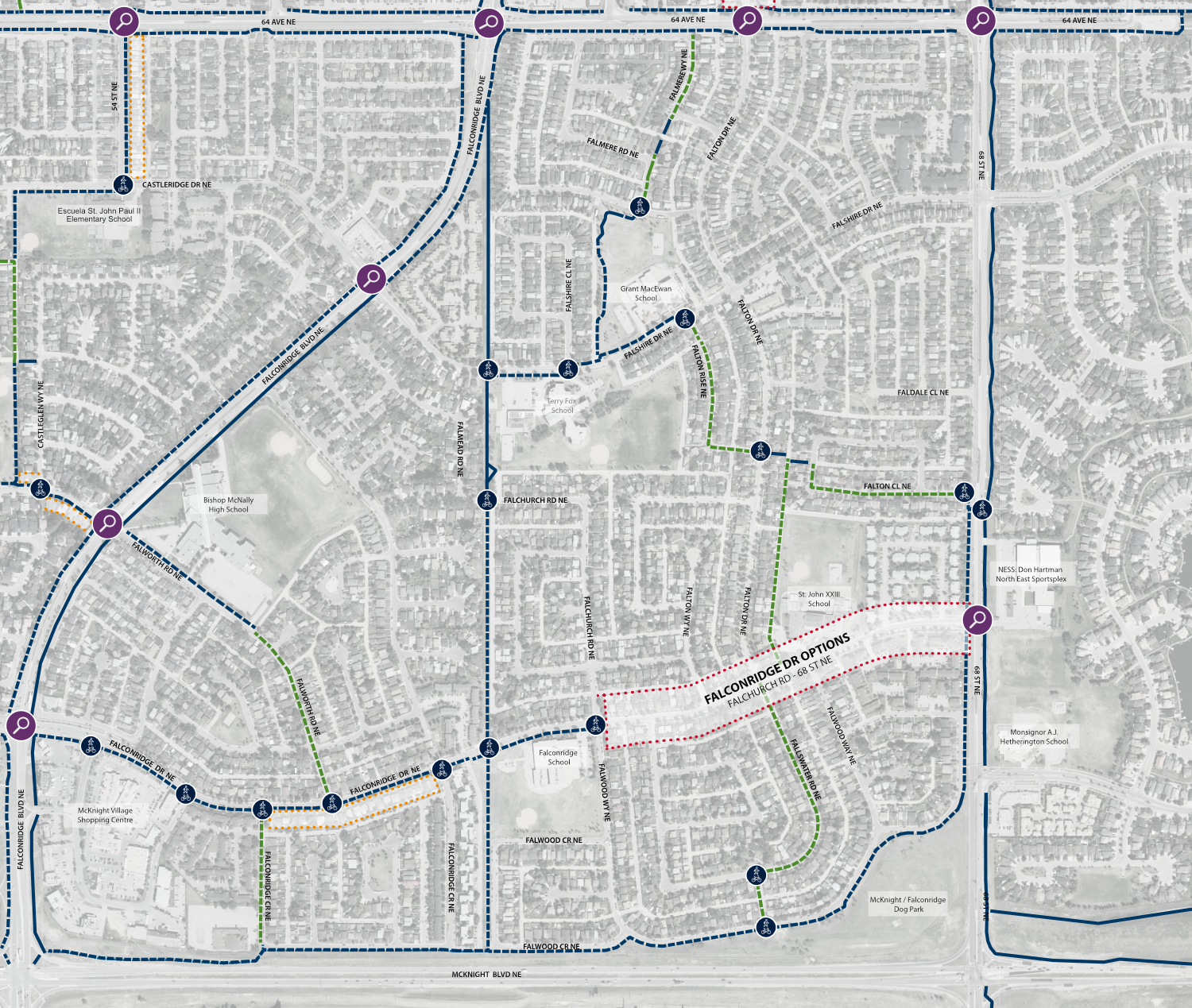
Map Legend

Castleridge
This map below shows the safety measures, pathways and bikeways we are proposing in Castleridge to safely connect people walking, biking and wheeling to home, school, parks, stores and services. *This is likely easier to view on a desktop than mobile phone.
Click on each colored dot to see what we are proposing in each area. Blue, yellow and green dots show places where we propose the most balanced solution to minimize impacts such as parking or tree loss. Although there are not options for you to select, there is still space for you to share your thoughts in the last question box.
The areas outlined in red (red dots) have more than one option with questions below about each option.

Map Legend
Phase 3: Reveal
Timeline
Timeline
-
Timeline item 1 - complete
Phase 1 - Discover:
Public Engagement – Spring / Summer / Fall 2024
- Identify local and site-specific challenges and opportunities that will help inform design options.
-
Timeline item 2 - active
Phase 2 - Explore:
Public Engagement – Spring 2025
- Present design options for citizen and interest holder feedback. Specifically, how does a design concept impact the following: parking, community access, pedestrian crossing, and safety, pedestrian comfort, cycling comfort and safety.
-
Timeline item 3 - incomplete
Phase 3 - Reveal:
Fall 2025
- Present the proposed design to citizens and interest holders and articulate rationale for the design choice.
Note: Individual project timelines will vary by Pathway and Bikeway Network project.


