Thank you for your feedback!
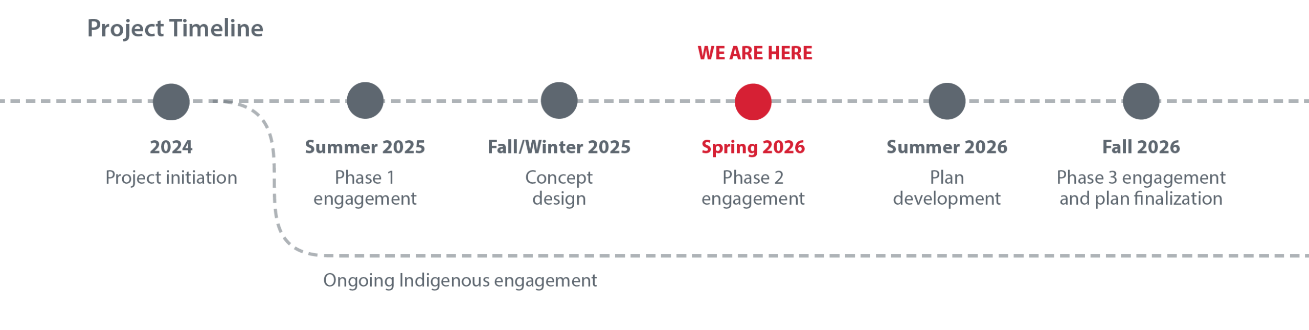
Phase 2 public engagement was open from April 7 – May 10. Check back soon for the What We Heard Report.
Medicine Hill / Paskapoo Slopes is a living cultural landscape with deep and ongoing Indigenous significance.
It is also a valued natural area used by surrounding communities and visitors from across Calgary. The City of Calgary is developing a Park Plan to guide the future use and care of the land in a way that supports ecological health, respectful access, and cultural stewardship.
In June–July 2025, The City invited the public to share values and priorities for the park. Since then, the project team has reviewed this feedback and explored key topics in more detail to inform the draft concepts now being shared in Phase 2.
In parallel, The City continues to engage Indigenous Nations connected to this landscape. Indigenous Design Principles developed through that engagement are helping shape the emerging Park Plan.
What is a park plan and why do we need one?
The City is developing a Park Plan to guide future decisions about:
- Access, safety, and how people move through the site
- Gathering areas and visitor experience
- Protecting natural areas, water, biodiversity, and wildlife habitat
- Supporting Indigenous cultural expression, stewardship, and learning
- Conserving and appropriately managing archaeological and culturally significant areas
- Trails and managing informal paths
This Park Plan will be a strategic, living document that brings together maps, design principles, and priorities into one cohesive approach. It will also outline a clear path forward, including how and when improvements could be implemented over time.
We recognize that many people cherish this natural area exactly as it is, and we agree that it’s a beautiful gem within our city. At the same time, natural areas do not remain healthy on their own. As use increases, leaving an area “unchanged” without intentional planning can unintentionally lead to damage over time. Thoughtful planning helps protect what people value most about this place, now and into the future.
Without a Park Plan, challenges can emerge including:
- trail widening, erosion, and soil compaction
- damage to sensitive ecological, cultural, and archaeological areas
- habitat fragmentation and disturbance to wildlife
- spread of invasive plant species
- increased wildfire risk
- conflicts between user groups
- safety concerns from informal trail creation and unauthorized features
- growing pressures related to access, parking, and circulation
By planning now, The City can take a proactive, respectful approach that prioritizes conservation, cultural stewardship, safety, and appropriate access, rather than reacting later to damage that is harder, or impossible, to undo.
Public feedback is an important input to the Park Plan, alongside Indigenous input, technical analysis, safety, policy direction, and long‑term sustainability considerations.

Medicine Hill / Paskapoo Slopes is located within the ancestral and traditional territories of the Blackfoot Confederacy (including the Siksika, Piikani, and Kainai First Nations), the Îethka Nakoda Wîcastabi First Nations (Chiniki, Bearspaw, and Goodstoney), and the Tsuut’ina First Nation. The area is also within the homeland of the historic Northwest Métis and the Otipemisiwak Métis Government.
For thousands of years, this area has been part of a broader network of seasonal camps, travel routes, harvesting areas, and places of cultural and spiritual significance connected to river corridors, natural features, and other landmarks across the region. Those relationships to the land continue today.
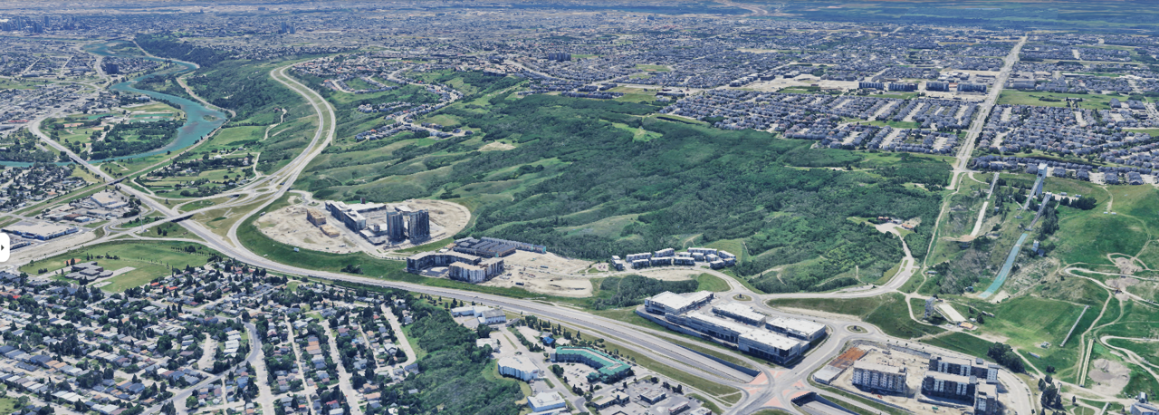
Within the last century, land uses in and around the area have shifted, from homesteading and quarry activity to recreation serving nearby neighbourhoods, WinSport programs, and school groups learning on the land. As use continues to grow, thoughtful planning is needed to reduce impacts on the landscape. This includes protection of sensitive ecosystems and cultural sites, improvements for safety and access for everyone and reductions in informal trails.
The park includes approximately 350 acres (142 hectares) bounded by the Trans‑Canada Highway, Canada Olympic Park, Sarcee Trail W, and the communities of Cougar Ridge, Patterson Heights, and West Springs.
What are the vision and goals of the Park Plan?
Vision
The park vision describes the long‑term role, character, and values of Medicine Hill / Paskapoo Slopes and helps guide future planning and decision‑making.
Medicine Hill / Paskapoo Slopes is a protected landscape where nature thrives, cultures are honoured, and communities connect. Home to unique plant communities, natural springs, diverse wildlife, and rich archaeological resources, it honours deep cultural connections to the land. Through respectful relationships, learning, trail‑based recreation, and shared stewardship, the park will be sustained and celebrated for generations to come.
Goals
These goals reflect what we’ve heard from the community, Indigenous Nations, user groups, and technical experts. They guide future decisions about protecting the land while supporting safe, respectful access and experiences.
Maintain the area’s natural character while enhancing ecological health through targeted restoration. Prioritize the protection of ecological habitats, riparian zones, and wildlife by managing invasive species, controlling erosion, and reducing habitat fragmentation.
Recognize and honour the longstanding cultural significance of these lands by acknowledging Indigenous histories, connections, and cultural values. Reflect Indigenous heritage in the park’s identity through thoughtful design, interpretation, and protocol-guided cultural practices. Respectfully acknowledge other cultural connections, such as those of the Buddhist community, in inclusive and meaningful ways.
Recognize the significance of what is among one of the densest concentrations of Pre-contact bison hunting (specifically through pounding techniques) and processing sites recorded to date in Alberta. Protect these fragile non-renewable resources from damage to promote education and respect.
Preserve trail-based recreation, including walking and biking activities that allow people to be immersed in nature. Enhance and improve the flow of the trail network and address points of conflict between users as well as site constraints. Sustainable trail design and management will help reduce these conflicts and minimize impacts on ecological systems, cultural practices, and archaeological resources.
Collaborate with user groups, volunteers, and organizations to maintain and protect the park. Promote responsible use and support community-led stewardship initiatives building on existing relationships with user groups and interest holders.
Provide educational opportunities about natural and cultural history through thoughtful interpretive elements and Indigenous-led programming. Ensure all cultural interpretation is guided by Indigenous Nations and respects traditional knowledge protocols.
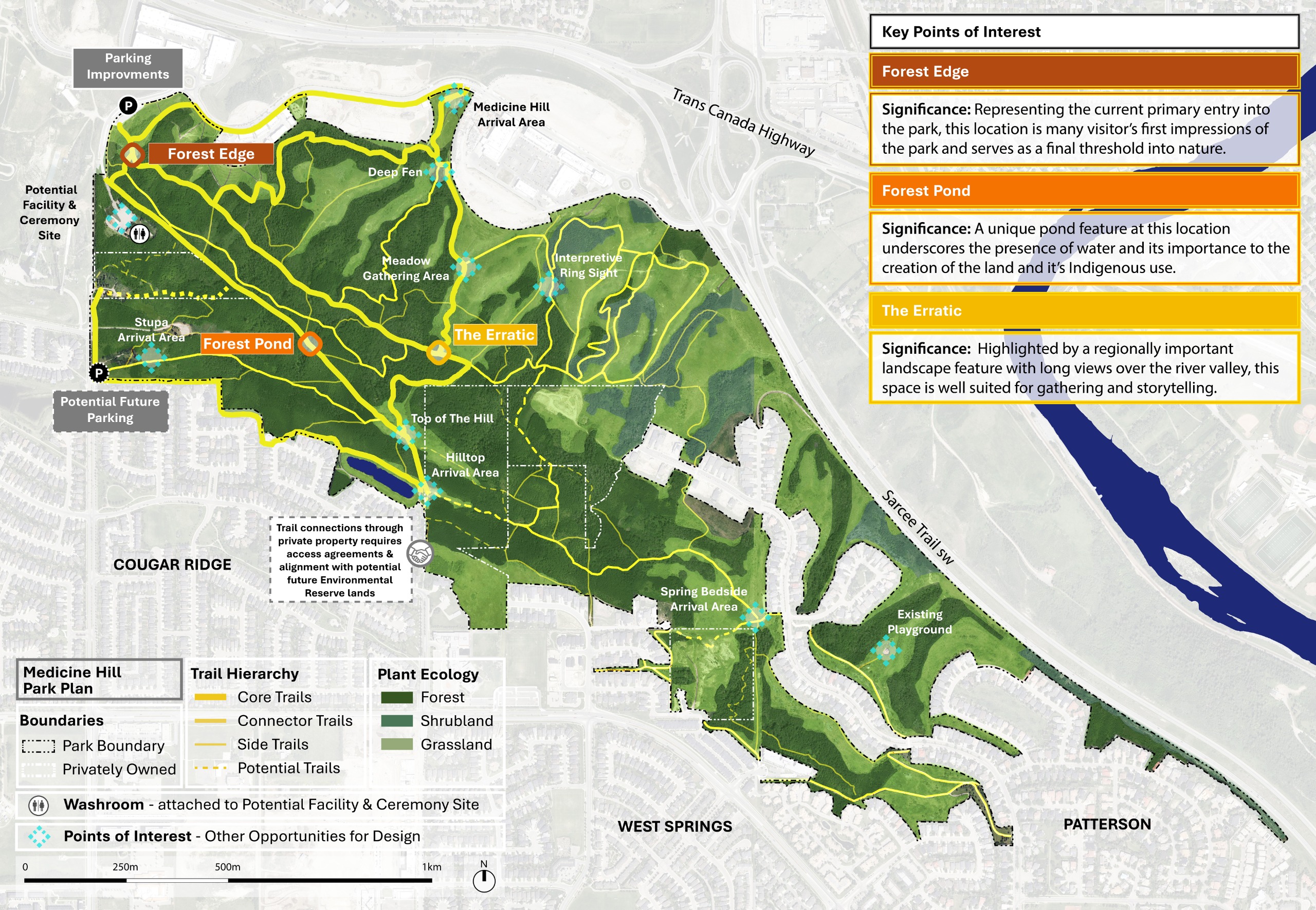
Phase 2 Draft Concept
This draft park concept presents a high-level vision, illustrated through a map of key areas and connections across the landscape. The key ideas shaping the draft concept plan are:
- A clearer, more intentional trail network: Improving trail routing, wayfinding, and access to better manage movement through the site.
- Stronger protection of natural and sensitive areas: Prioritizing ecological restoration and protecting waterways, habitat, archaeology, and culturally significant areas.
- Spaces that support learning, culture, and stewardship: Identifying locations for education, Indigenous cultural presence, and stewardship opportunities.
- Respectful recognition of Indigenous history and ongoing presence: Honouring Indigenous cultures and enabling ongoing cultural practices through planning and future guidance.
- Improved access and visitor experience: Exploring parking, access points, washrooms, and key activity areas to support safe and appropriate use
The map is interactive, click on the flashing icons to learn more about the Movement Concept and key Points of Interest. You can also use the links to explore more information about the key elements of the Park Plan.
![]() To zoom in and out, press the arrow button in the top right corner of the map.
To zoom in and out, press the arrow button in the top right corner of the map.
Survey
Additional information
What's next
Your feedback matters
- All feedback shared during Phase 2 will be compiled into a public What We Heard Report and released following the engagement period. What we hear from you on the draft concepts will be used to refine the ideas and help shape a preferred concept for the park.
Stay involved
- The preferred concept will be shared with the public in the next phase and you’ll have another opportunity to provide input before the Park Plan is finalized.
From plan to action
- The final Medicine Hill / Paskapoo Slopes Park Plan will include an implementation plan and phasing strategy. Park improvements will be built in phases over time, allowing parts of the park to remain open and accessible while work is underway. Phasing also helps The City plan funding and approvals in a thoughtful, manageable way
✚ Documents
✚ Frequently asked questions (F.A.Q.)
FAQ
✚ Previous engagement: Phase 1
Phase 1 of public engagement took place between June 16 and July 21, 2025.
-
-
Phase 1 Archive


