Thank you for participating in Phase 3!

Engagement was open between August 15 - August 29, 2025. A What We Heard Report will be published in the coming weeks.

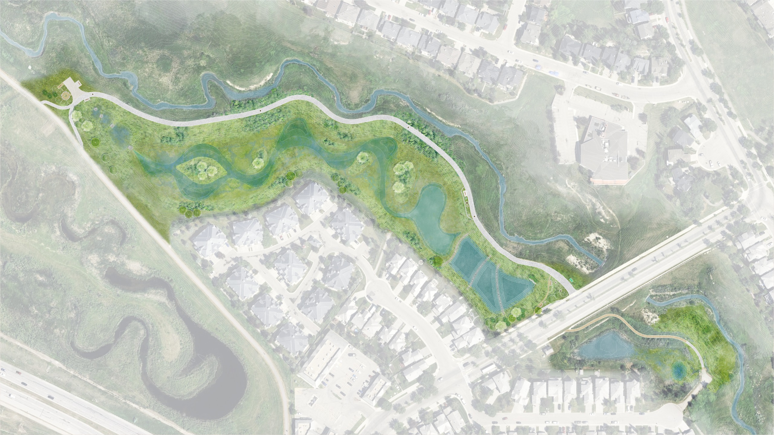
Thank you for participating in our engagement. Based on your feedback, and in line with technical, environmental, budgetary, and regulatory requirements - we are excited to share the final design plan for the public realm features for the Hanson Ranch Constructed Wetlands Improvements project. Please see the design plan below, with rationale for the design choice, anticipated construction impacts and timeline details.

What We Heard / What We Did

  • Natural look and feel

    What we heard: Most people prefer a natural look with native vegetation and no fencing. Some are concerned about maintenance vehicles using the access route.

    What we did: We significantly revised the east end design by removing the pier lookout, fencing, and bike racks. This keeps a natural look with gravel trails to benches, while still allowing maintenance vehicle access as required.

  • Wildlife

    What we heard: Some were concerned that infrastructure could reduce wildlife space, while others supported the current design. Overall, people want a balance between social features and preserving the wetlands habitat for wildlife.

    What we did: We updated both social areas to include benches with back support and informal boulder seating under trees for shade. To reduce infrastructure, we removed the pier lookout, railing, and bike racks. Maintenance vehicle access is still required for upkeep.

  • Seating

    What we heard: Benches with back support and boulder-style seating were most preferred. Log benches and built-in seating followed, while picnic tables and tree stumps were least favored.

    What we did: Based on accessibility feedback, the proposed seating includes mainly benches with back support, along with informal boulder seating at the west end.

  • Inspiring ideas

    What we heard: Some submissions suggested adding a walking platform within the constructed wetland area.

    What we did: To provide space for wildlife, maintain a more natural aesthetic, and keep maintenance costs low, this submission was not developed for the final design.

  • Construction impacts

    What we heard: Concerns about the loss of enjoyment and health benefits of the area, noise, dust, traffic and pathway impacts, and disruptions to wildlife were the main items.

    What we did: Construction will impact the public in several ways. Please see our section below on “What to Expect During Construction – Impacts and Mitigations".

  • Amenities

    What we heard: Water features, educational signage, and the pier lookout were generally well received. Informal gathering spaces or outdoor classrooms had some support, while bike racks were the least favoured.

    What we did: To support a natural aesthetic, the pier lookout, railing, and bike racks were removed. Seating remains for viewing, water features will be included, and educational signage is still being considered. The west-end pathway connection to the regional trail has been improved.

  • Gathering space

    What we heard: Feedback was mixed, but many liked the idea of casual seating for group gatherings. The western area’s design was seen as more natural, with gathering spaces set off from the main pathways.

    What we did: The west end design was mostly kept, but the terraced seating was simplified to a single bench near the wetland due to concerns. The gathering space remains off the path, with added trees to enhance the natural feel and provide shade.

Features and Amenities Design

Click on the flashing hotspots below to view the location and details of the features and amenities.

  • West area

    This location will include accessible seating at key lookout points, an outdoor classroom, and a maintenance vehicle turnaround. This node will be framed by trees and natural vegetation.

  • Central area

    This location is key to the wetlands function. Recirculation pipes from the main pool connect at pumps located here before directing water back to the forebay and polishing marshes. An accessible bench is also located here as a stopping point to look out at the wetland.

  • East area

    This location will have a gravel trail tucked into the slope with benches. The area will have generous tree cover and native vegetation.

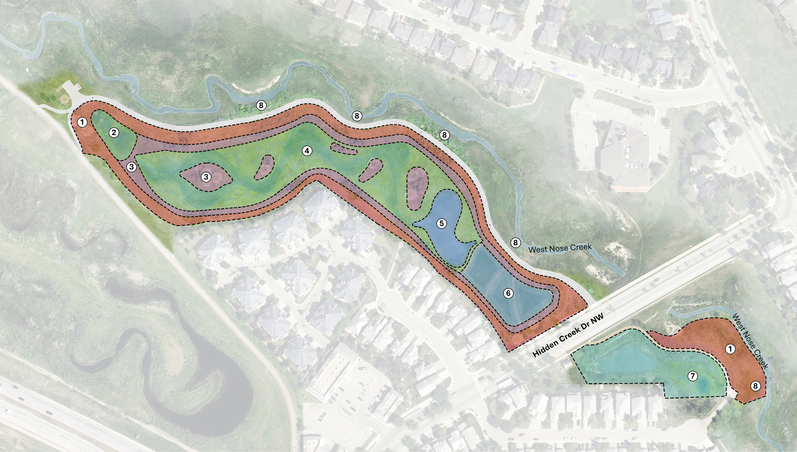
Wetland Habitat Design

Click on the flashing hotspot below that shows the different zones to improve the diversity of vegetation, animal habitat, and water quality.

What to expect during construction: Impacts and mitigations

We are doing our best to minimize disturbance caused by construction throughout the duration of the project.

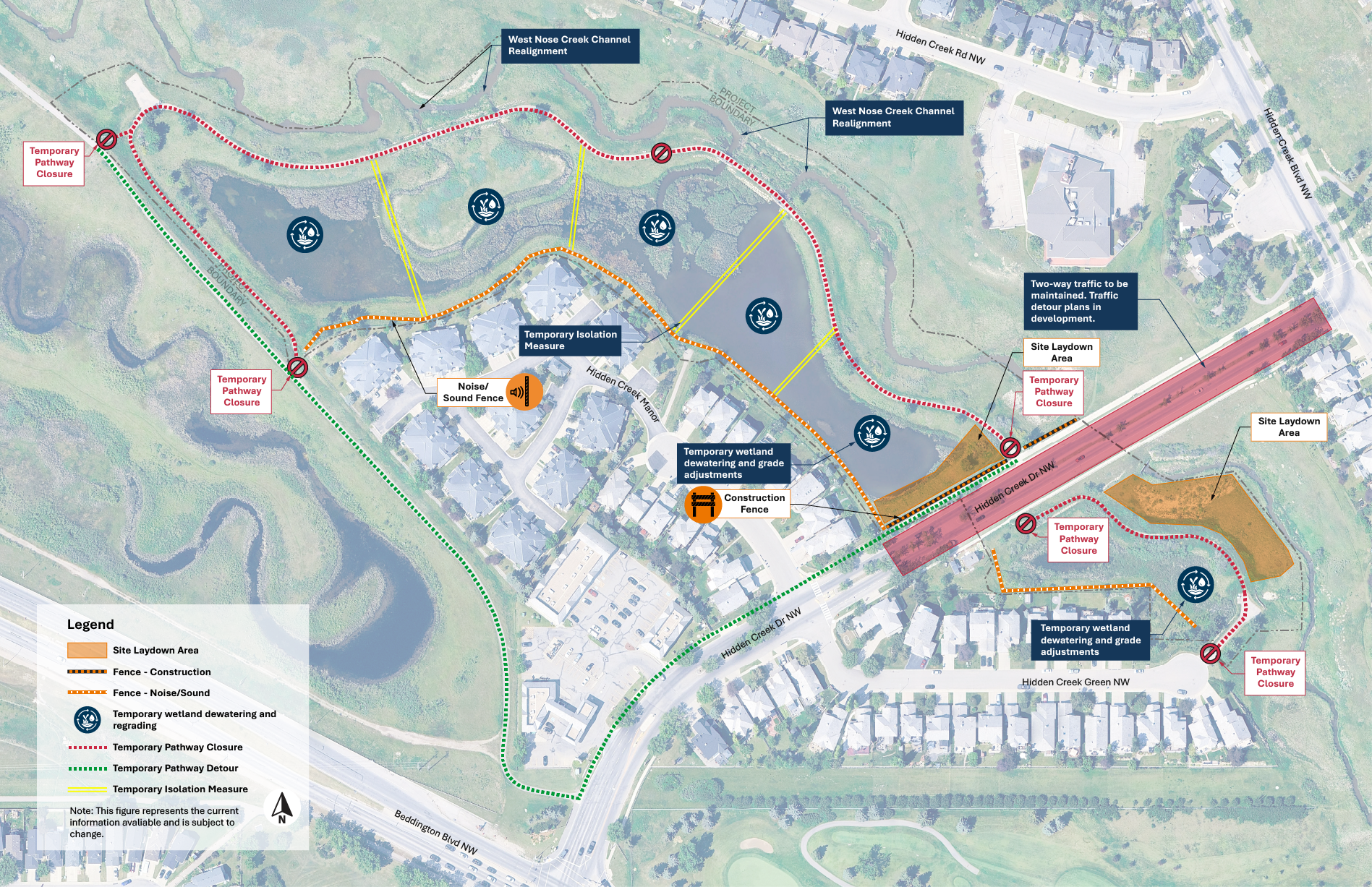
Construction impacts diagram

We are developing a traffic management plan(s) which will aim to minimize disruption to the public while balancing the need for efficient project execution. We are doing our best to develop plans that limit the amount of travel in residential areas and to minimize road and lane closures. We will be maintaining two-way traffic on Hidden Creek Drive and people should expect alterations to lanes and traffic flow throughout construction.

We will have dust mitigation controls in effect in areas close to homes in the event dust becomes an issue.

There will be noise and diesel exhaust created from excavators, construction truck traffic, water pumps, generators and possibly from organic matter from the existing sediment.

Due to the various stages of construction that factors in maintaining wildlife habitat, the pathway will be closed from approximately the end of August to spring 2027. Detour signage will be posted, including the alternate route map which will be posted on the project webpage once it is developed.

Due to the various stages of construction that factors in maintaining wildlife habitat, the pathway will be closed from approximately the end of August to spring 2027. Detour signage will be posted, including the alternate route map which will be posted on the project webpage once it is developed.

Our community business relations team will have periodic community engagement through regular liaison and check-ins with residents and businesses during construction.

The project requires a Biophysical Impact Assessment (BIA) which is reviewed and approved under the City of Calgary’s framework. The BIA has identified affected wildlife species and habitat and we are applying their recommended efforts to help mitigate impacts.

We will be using vibration monitoring machines in areas close to homes (less than 20 metres). This ensures vibration from construction is within the acceptable limit.


Previous engagement

Click ➜

Click the above tabs to view previous public engagement.

Closed: Phase 2 Project overview

We have made progress towards meeting the environmental regulatory requirements to improve the Hanson Ranch Wetland. This means the project is ready to move to Phase 2 Engagement, where you get to have your say!

In Phase 1, we heard:

  • Community desire to be involved in selecting features and materials for the site, once regulatory requirements have been met.
  • How important wildlife habitat protection is to the community.
  • How the pathway conditions, connectivity and accessibility need improvements.
  • How maintaining a natural setting (as opposed to a functional only site) is desired.

You can view the full Phase 1 What We Heard Report here.

The project team have worked on proposed design concepts to ensure we are delivering what the community wants and values the most.

We are presenting a variety of public realm features, amenities and materials in our survey below for you to tell us your preferences and share your ideas.

Your feedback will be compiled into a report and shared with the project team ahead of the final design.


Share your thoughts!

We value your participation in our combined effort to improve the Hanson Ranch Wetland to a fully functioning and visually appealing site for the community to enjoy.

Please note that the final design concept will consider a balance of factors including community feedback, site constraints, environmental impacts, operations, and financial consideration.

The photographic images included with the plans below are considered “precedent images,” which means they are a representation, showing elements that are similar to what you might see in the finished design. Keep in mind the final elements are not likely to look exactly like the images shown here.

These are concepts only and the final project is subject to change.


What's next?


A What We Heard Report for the second phase of our engagement process will be available by December 2024 and published on this page.

The feedback gathered as part of the engagement, along with results of technical analyses, will be used to guide the final design of the public realm elements, which will be revealed in Phase 3 Engagement next year.

Provincial and federal regulatory approvals will be submitted ahead of procuring a construction contractor. Once initiated, it is anticipated construction will take about two years to complete. After construction, the site will be monitored and maintained in collaboration with the contractor for another four to five years. The City will provide ongoing maintenance at the site thereafter.

We are grateful for all the great feedback and conversations we have had so far in the community, and we look forward to advancing this project.

Photo submissions received in Phase 2:


You see the results of decisions made by The City of Calgary every day. Get involved and provide your input on City projects and programs. Together we can build a better city.

Land Acknowledgement:

“We appreciate and acknowledge that we live, work, and play on the ancestral and traditional territories of the Blackfoot confederacy, made up of the Siksika, Piikani, Amskaapipiikani and Kainai First Nations; the Îethka Nakoda Wîcastabi First Nations, comprised of the Chiniki, Bearspaw, and Goodstoney First Nations; and the Tsuut’ina First Nation.

The City of Calgary is also homeland to the historic Northwest Métis and to the Otipemisiwak Métis Government, Métis Nation Battle River Territory (Nose Hill Métis District 5 and Elbow Métis District 6). We acknowledge all Indigenous people who have made Calgary their home.”

Contact Us

Have questions or want to learn more about a project, contact us below:

Contact Information
Phone 311 or 403-268-CITY (2489)
Email engage@calgary.ca
Website www.calgary.ca