WHAT IS HAPPENING TO MY ROUTE?
PROPOSED CHANGES
Click on each tab to learn more on how each of these routes have been modified. On these maps the dotted line is the current route and the coloured line is the proposed route.
13
This route is proposed to be modified. Two revisions are proposed from the existing Route 13:
- Instead of routing on 37 Street SW and Richmond Road SW, Route 13 will instead serve Glamorgan via 46 Avenue and 50 Street SW. Alternative service on Richmond Road is provided by proposed Route 22, and on 37 Street SW by the existing Route 9 and MAX Teal.
- In the Elbow Park community, the route would use Council Way instead of 36 Avenue. This provides a connection point to Route 7 and proposed Route 22, improving access to Marda Loop.
Proposed Route 13 Routing:
Northbound:
- Start at Westhills Shopping Centre on Stewart Green SW
- East on Richmond Road SW
- South on 50 Street SW
- East on 46 Avenue SW, continuing east to Richardson Way SW
- Stop at Mount Royal Bus Terminal
- Continue East on Richardson Way SW
- West on Richard Road SW
- East on 50 Avenue SW
- North on 16 Street SW
- East on 38 Avenue SW
- North on 14 Street SW
- East on Council Way SW
- North through Mount Royal community along 10 Street SW
- North on 8 Street SW
- East on 5 Avenue SW
- South on 1 Street SW – stop by the Bay
Southbound:
- Start on 1 Street SW by the Bay
- South on 1 Street SW
- West on 11 Avenue SW
- South on 8 Street SW
- South through Mount Royal community along Carleton Street SW
- West on Council Way SW
- South on 14 Street SW
- West on 38 Avenue SW
- South on 16 Street SW
- West on 50 Avenue SW
- East on Richard Road SW
- West on Richardson Way SW
- Stop at Mount Royal University Bus Terminal
- Continue west on Richardson Way SW, continuing west on 46 Avenue SW
- North on 50 Street SW
- Stop at Richmond Bus Terminal
- West on Richmond Road
- End at Westhills Shopping Centre on Stewart Green SW
Outside of weekday rush hour periods, Route 13 will have an alternate routing in Glamorgan in the westbound direction only.
- From westbound 46 Avenue
- South on 43 Street SW
- West on Galbraith Drive SW
- West on 49 Avenue SW
- North on 45 Street SW
- West on 46 Avenue SW, continue to rest of regular route and Westhills Shopping Centre.
Route 13 service levels. Proposed to operate every 15 minutes during peak periods, every 25 minutes during mid-day periods and during evenings until 9 pm. Late evening and weekend service would be provided every 33 minutes.
Route 13 would operate until approximately 12:30am on weekdays, and until midnight on weekends.
Key Locations Served:
- Westhills Shopping Centre
- Mount Royal University
- Beltline
- Downtown
Proposed Route 22 routing:
Eastbound:
- Start at Westhills Shopping Centre on Stewart Green SW
- East on Richmond Road SW, continuing east on 33 Avenue SW through Marda Loop
- North on 14 Street SW
- East on 9 Avenue SW
- North on 1 Street SW – stop by The Bay
Westbound:
- Start on 1 Street SW by The Bay
- North on 1 Street SW
- West on 6 Avenue SW
- South on 14 Street SW
- West on 33 Avenue SW, continuing west through Marda Loop
- West on Richmond Road SW
- Stop at Richmond Terminal
- West on Richmond Road SW
- End at Westhills Shopping Centre on Stewart Green SW
Route 22 service levels. Proposed to operate every 15 minutes during weekday peak periods and every 22 minutes during mid-day and evenings until 9pm. The route will also operate every 22 minutes during the day on Saturday and Sunday. Evening service would be provided every 35 minutes.
The route is proposed to operate until midnight on weekdays, 11:30pm on Saturdays, and 10:45pm on Sundays.
Key Locations Served:
- Westhills Shopping Centre
- Richmond Road Corridor
- Marda Loop
- Beltline
- Downtown

Dotted line = current route
Coloured line = proposed route
(Click to enlarge)
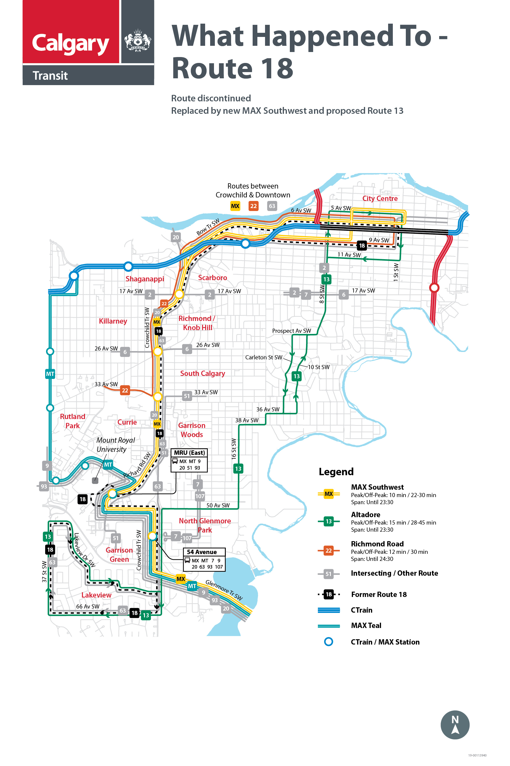
18
This route is proposed to be discontinued. Service between Mount Royal University and Downtown to be provided on the new MAX Southwest. Service to Lakeview to be replaced by proposed Route 66.
The routing in the Lakeview community is also proposed to be changed, to use 34 Street and Lakeview Drive instead of 37 Street as today. This reduces overall walk distances, and improves travel times to downtown for residents in the west and north parts of the community.
MAX Southwest routing:
Northbound:
- Start in Woodbine on 24 Street SW
- North on 24 Street SW
- East on Southland Drive
- North on Transitway beside 14 Street SW
- North on 14 Street SW
- West on Glenmore Trail SW
- North on Crowchild Trail SW
- West on 50 Avenue SW
- North on Richard Road SW
- North on Crowchild Trail SW
- East on Bow Trail SW, continuing east on 9 Avenue SW
- North on 6 Street SW
- East on 5 Avenue SW – ends near 1 Street SW
Southbound:
- Start on 5 Avenue at 1 Street SW
- South on 1 Street SW
- West on 6 Avenue SW, continuing west on Bow Trail SW
- South on Crowchild Trail SW
- South on Richard Road SW
- East on 50 Avenue SW
- South on Crowchild Trail SW
- East on Glenmore Trail SW
- South on 14 Street SW
- South on Transitway beside 14 Street SW
- West on Southland Drive SW
- South on 24 Street SW
- End at Woodbine on 24 Street SW
Key Locations Served:
- Southland Leisure Centre
- Glenmore Landing
- Rockyview Hospital
- Mount Royal University
- Marda Loop
- Downtown
MAX Southwest service levels. Will operate every 10 minutes during weekday peak periods, every 22 minutes during weekday mid-day periods, and every 25 to 30 minutes during all other service periods. Service is provided until approximately 11:30pm on weekdays, and to 10:30pm on weekends.
Proposed Route 66 routing:
Northbound:
- Start at Lakeview Plaza, on southbound Crowchild Trail at 63 Avenue SW
- South on Crowchild Trail SW
- West on 66 Avenue SW
- North on 34 Street SW
- East on 58 Avenue SW
- North on Lakeview Drive SW
- South on 37 Street SW
- West on Strathcona Street
- North on Grey Eagle Boulevard, continuing north over Glenmore Trail to 37 Street SW
- East on Richardson Way SW
- Stop at Sarcee Road MAX Station – approximately 5 minute walk from Mount Royal University
- North on Sarcee Road SW
- East on 33 Avenue SW
- North on Crowchild Trail
- East on Bow Trail SW, continuing east on 9 Avenue SW to downtown
- North on 1 Street SW – stop by The Bay
Westbound:
- Start on 1 Street SW by The Bay
- North on 1 Street SW
- West on 6 Avenue SW, continuing west on Bow Trail
- South on Crowchild Trail SW
- West on 33 Avenue SW
- South on Sarcee Road SW
- West on Richardson Way SW, stopping at Sarcee Road MAX Station
- South on 37 Street SW, continuing over Glenmore Trail to Grey Eagle Boulevard
- East on Strathcona Street SW
- North on 37 Street SW
- East on Lakeview Drive SW
- East on Lancaster Way SW
- East on 63 Avenue SW
- South on Crowchild Trail, ending at Lakeview Plaza
Route 66 service levels. Proposed to operate every 15 minutes during weekday peak periods and every 22 minutes during mid-day and evenings until 9pm. The route will also operate every 22 minutes during the day on Saturday and Sunday. Evening service would be provided every 33 minutes.
The route is proposed to operate until 12:30 am every day.
Key Locations Served:
- Lakeview
- Mount Royal University (via Sarcee Road MAX Station)
- Sarcee Road
- Marda Loop
- Downtown

Dotted line = current route
Coloured line = proposed route
(Click to enlarge)
47
This route is proposed to be discontinued and replaced by proposed Route 66.
Service in Lakeview will be provided on Route 66. Customers heading to Glenmore Trail or Chinook LRT Station will need to connect to the existing Route 9 at Sarcee Road MAX Station.
Proposed Route 66 routing:
Northbound:
- Start at Lakeview Plaza, on southbound Crowchild Trail at 63 Avenue SW
- South on Crowchild Trail SW
- West on 66 Avenue SW
- North on 34 Street SW
- East on 58 Avenue SW
- North on Lakeview Drive SW
- South on 37 Street SW
- West on Strathcona Street
- North on Grey Eagle Boulevard, continuing north over Glenmore Trail to 37 Street SW
- East on Richardson Way SW
- Stop at Sarcee Road MAX Station – approximately 5 minute walk from Mount Royal University
- North on Sarcee Road SW
- East on 33 Avenue SW
- North on Crowchild Trail
- East on Bow Trail SW, continuing east on 9 Avenue SW to downtown
- North on 1 Street SW – stop by The Bay
Westbound:
- Start on 1 Street SW by The Bay
- North on 1 Street SW
- West on 6 Avenue SW, continuing west on Bow Trail
- South on Crowchild Trail SW
- West on 33 Avenue SW
- South on Sarcee Road SW
- West on Richardson Way SW, stopping at Sarcee Road MAX Station
- South on 37 Street SW, continuing over Glenmore Trail to Grey Eagle Boulevard
- East on Strathcona Street SW
- North on 37 Street SW
- East on Lakeview Drive SW
- East on Lancaster Way SW
- East on 63 Avenue SW
- South on Crowchild Trail, ending at Lakeview Plaza
Route 66 service levels. Proposed to operate every 15 minutes during weekday peak periods and every 22 minutes during mid-day and evenings until 9pm. The route will also operate every 22 minutes during the day on Saturday and Sunday. Evening service would be provided every 33 minutes.
The route is proposed to operate until 12:30 am every day.
Key Locations Served:
- Lakeview
- Mount Royal University (via Sarcee Road MAX Station)
- Sarcee Road
- Marda Loop
- Downtown

Dotted line = current route
Coloured line = proposed route
(Click to enlarge)
63
This route is proposed to be discontinued. Service between Lakeview and downtown to be replaced by proposed Route 66.
The routing in the Lakeview community is also proposed to be changed, to use 34 Street and Lakeview Drive instead of 37 Street as today. This reduces overall walk distances, and improves travel times to downtown for residents in the west and north parts of the community.
Proposed Route 66 routing:
Northbound:
- Start at Lakeview Plaza, on southbound Crowchild Trail at 63 Avenue SW
- South on Crowchild Trail SW
- West on 66 Avenue SW
- North on 34 Street SW
- East on 58 Avenue SW
- North on Lakeview Drive SW
- South on 37 Street SW
- West on Strathcona Street
- North on Grey Eagle Boulevard, continuing north over Glenmore Trail to 37 Street SW
- East on Richardson Way SW
- Stop at Sarcee Road MAX Station – approximately 5 minute walk from Mount Royal University
- North on Sarcee Road SW
- East on 33 Avenue SW
- North on Crowchild Trail
- East on Bow Trail SW, continuing east on 9 Avenue SW to downtown
- North on 1 Street SW – stop by The Bay
Westbound:
- Start on 1 Street SW by The Bay
- North on 1 Street SW
- West on 6 Avenue SW, continuing west on Bow Trail
- South on Crowchild Trail SW
- West on 33 Avenue SW
- South on Sarcee Road SW
- West on Richardson Way SW, stopping at Sarcee Road MAX Station
- South on 37 Street SW, continuing over Glenmore Trail to Grey Eagle Boulevard
- East on Strathcona Street SW
- North on 37 Street SW
- East on Lakeview Drive SW
- East on Lancaster Way SW
- East on 63 Avenue SW
- South on Crowchild Trail, ending at Lakeview Plaza
Route 66 service levels. Proposed to operate every 15 minutes during weekday peak periods and every 22 minutes during mid-day and evenings until 9pm. The route will also operate every 22 minutes during the day on Saturday and Sunday. Evening service would be provided every 33 minutes.
The route is proposed to operate until 12:30 am every day.
Key Locations Served:
- Lakeview
- Mount Royal University (via Sarcee Road MAX Station)
- Sarcee Road
- Marda Loop
- Downtown

Dotted line = current route
Coloured line = proposed route
(Click to enlarge)
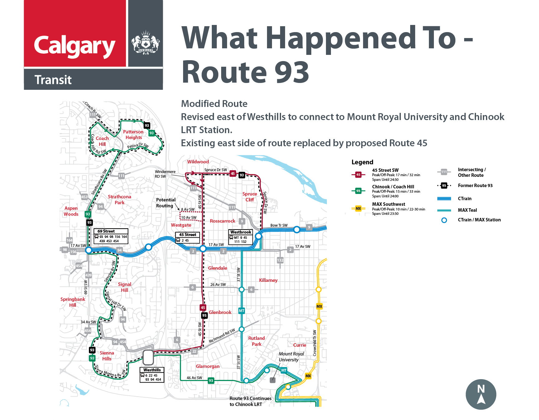
93
In March we originally proposed changes to Route 93 that would reroute it from Coach Hill to Chinook LRT Station, via Westhills Shopping Centre. The revised route proposals would reinstate the existing version of Route 93. As a result, the following routes from March are no longer proposed:
- 45 – 45 Street SW
- 93 – Coach Hill / Chinook
Service on 45 Street SW and in the communities of Wildwood and Spruce Cliff would again be provided by the existing Route 93. Service on 46 Avenue SW in Glamorgan would be instead provided on proposed Route 13. Connections to Chinook will be available via the existing Route 9.
Calgary Transit is continuing to review feedback for routes outside of the revised route proposal area. This includes consideration of the routing through the Westgate community.

Dotted line = current route
Coloured line = proposed route
(Click to enlarge)
107
This route is proposed to be discontinued. Service between 33 Avenue and downtown is available on the Proposed Route 22. Customers near 54 Avenue Terminal may also use the new MAX Southwest. Alternative service to downtown for all customers is also provided on the existing Route 7.
Proposed Route 22 routing:
Eastbound:
- Start at Westhills Shopping Centre on Stewart Green SW
- East on Richmond Road SW, continuing east on 33 Avenue SW through Marda Loop
- North on 14 Street SW
- East on 9 Avenue SW
- North on 1 Street SW – stop by The Bay
Westbound:
- Start on 1 Street SW by The Bay
- North on 1 Street SW
- West on 6 Avenue SW
- South on 14 Street SW
- West on 33 Avenue SW, continuing west through Marda Loop
- West on Richmond Road SW
- Stop at Richmond Terminal
- West on Richmond Road SW
- End at Westhills Shopping Centre on Stewart Green SW
Route 22 service levels. Proposed to operate every 15 minutes during weekday peak periods and every 22 minutes during mid-day and evenings until 9pm. The route will also operate every 22 minutes during the day on Saturday and Sunday. Evening service would be provided every 35 minutes.
The route is proposed to operate until midnight on weekdays, 11:30pm on Saturdays, and 10:45pm on Sundays.
Key Locations Served:
- Westhills Shopping Centre
- Richmond Road Corridor
- Marda Loop
- Beltline
- Downtown

Dotted line = current route
Coloured line = proposed route
(Click to enlarge)
112
This route is proposed to be discontinued and replaced by proposed Routes 13 and 66.
Service between Sarcee Road and Downtown will be provided on Route 66, following the same routing as the existing Route 112. Service in Glamorgan on 46 Avenue SW is provided by the proposed Route 13.
Proposed Route 13 Routing:
Northbound:
- Start at Westhills Shopping Centre on Stewart Green SW
- East on Richmond Road SW
- South on 50 Street SW
- East on 46 Avenue SW, continuing east to Richardson Way SW
- Stop at Mount Royal Bus Terminal
- Continue East on Richardson Way SW
- West on Richard Road SW
- East on 50 Avenue SW
- North on 16 Street SW
- East on 38 Avenue SW
- North on 14 Street SW
- East on Council Way SW
- North through Mount Royal community along 10 Street SW
- North on 8 Street SW
- East on 5 Avenue SW
- South on 1 Street SW – stop by the Bay
Southbound:
- Start on 1 Street SW by the Bay
- South on 1 Street SW
- West on 11 Avenue SW
- South on 8 Street SW
- South through Mount Royal community along Carleton Street SW
- West on Council Way SW
- South on 14 Street SW
- West on 38 Avenue SW
- South on 16 Street SW
- West on 50 Avenue SW
- East on Richard Road SW
- West on Richardson Way SW
- Stop at Mount Royal University Bus Terminal
- Continue west on Richardson Way SW, continuing west on 46 Avenue SW
- North on 50 Street SW
- Stop at Richmond Bus Terminal
- West on Richmond Road
- End at Westhills Shopping Centre on Stewart Green SW
Outside of weekday rush hour periods, Route 13 will have an alternate routing in Glamorgan in the westbound direction only.
- From westbound 46 Avenue
- South on 43 Street SW
- West on Galbraith Drive SW
- West on 49 Avenue SW
- North on 45 Street SW
- West on 46 Avenue SW, continue to rest of regular route and Westhills Shopping Centre.
Route 13 service levels. Proposed to operate every 15 minutes during peak periods, every 25 minutes during mid-day periods and during evenings until 9 pm. Late evening and weekend service would be provided every 33 minutes.
Route 13 would operate until approximately 12:30am on weekdays, and until midnight on weekends.
Key Locations Served:
- Westhills Shopping Centre
- Mount Royal University
- Beltline
- Downtown
Proposed Route 66 routing:
Northbound:
- Start at Lakeview Plaza, on southbound Crowchild Trail at 63 Avenue SW
- South on Crowchild Trail SW
- West on 66 Avenue SW
- North on 34 Street SW
- East on 58 Avenue SW
- North on Lakeview Drive SW
- South on 37 Street SW
- West on Strathcona Street
- North on Grey Eagle Boulevard, continuing north over Glenmore Trail to 37 Street SW
- East on Richardson Way SW
- Stop at Sarcee Road MAX Station – approximately 5 minute walk from Mount Royal University
- North on Sarcee Road SW
- East on 33 Avenue SW
- North on Crowchild Trail
- East on Bow Trail SW, continuing east on 9 Avenue SW to downtown
- North on 1 Street SW – stop by The Bay
Westbound:
- Start on 1 Street SW by The Bay
- North on 1 Street SW
- West on 6 Avenue SW, continuing west on Bow Trail
- South on Crowchild Trail SW
- West on 33 Avenue SW
- South on Sarcee Road SW
- West on Richardson Way SW, stopping at Sarcee Road MAX Station
- South on 37 Street SW, continuing over Glenmore Trail to Grey Eagle Boulevard
- East on Strathcona Street SW
- North on 37 Street SW
- East on Lakeview Drive SW
- East on Lancaster Way SW
- East on 63 Avenue SW
- South on Crowchild Trail, ending at Lakeview Plaza
Route 66 service levels. Proposed to operate every 15 minutes during weekday peak periods and every 22 minutes during mid-day and evenings until 9pm. The route will also operate every 22 minutes during the day on Saturday and Sunday. Evening service would be provided every 33 minutes.
The route is proposed to operate until 12:30 am every day.
Key Locations Served:
- Lakeview
- Mount Royal University (via Sarcee Road MAX Station)
- Sarcee Road
- Marda Loop

Dotted line = current route
Coloured line = proposed route
(Click to enlarge)
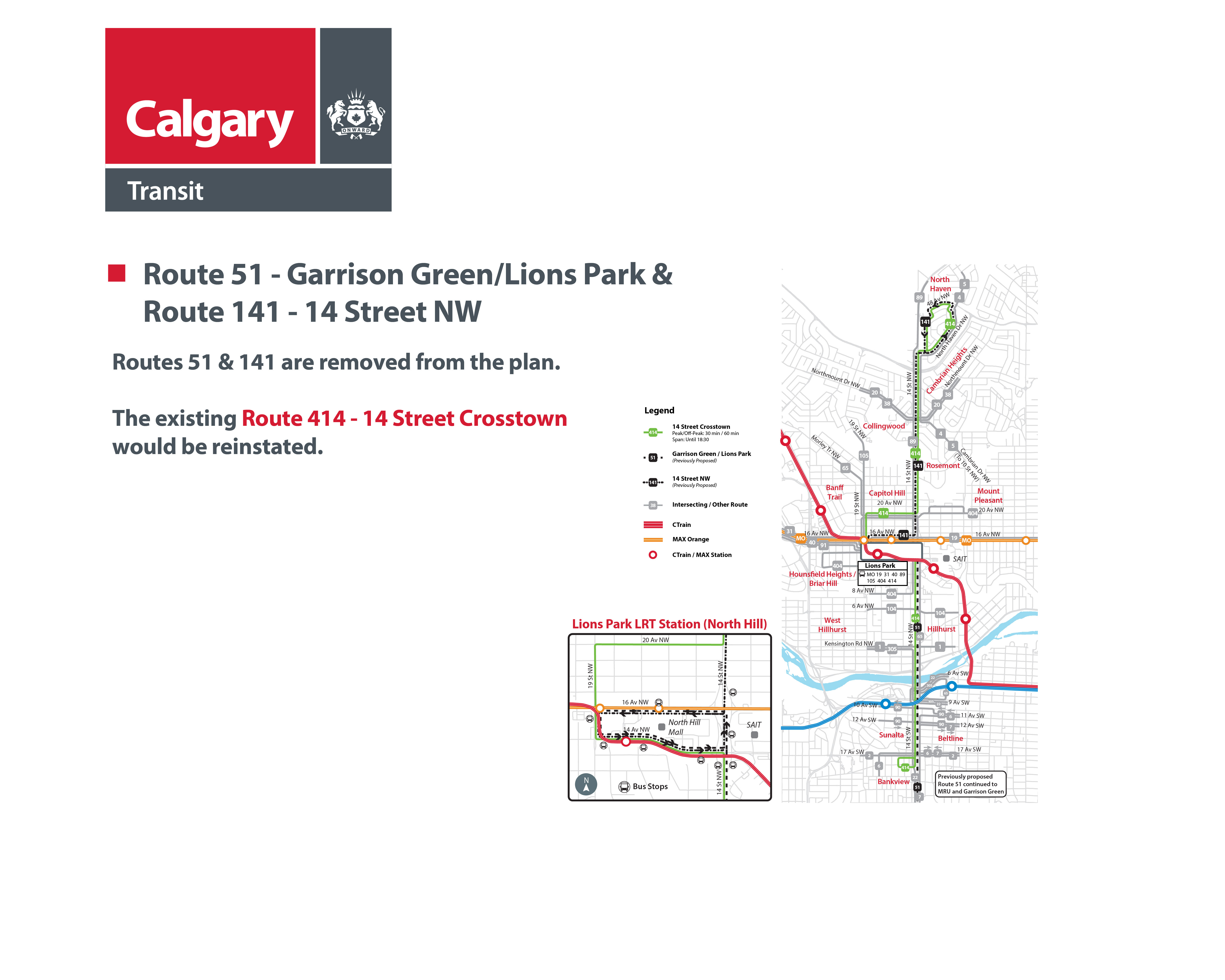
414
In March we originally proposed changes to Route 414. This would discontinue the Route 414, and replace it with two other routes on the same corridors. The revised route proposals would reinstate the existing version of Route 414. As a result, the following routes from March are no longer proposed:
- 51 – Garrison Green / Lions Park
- 141 – 14 Street NW
The previously proposed extension of Route 51 to Marda Loop, Mount Royal University, and Garrison Green community is no longer proposed. Service from Beltline to Marda Loop will be available on the existing Route 7, and the proposed Route 22.
Other trips that would be made possible by the extension would continue to require connections as they do today.
Dotted line = current route
Coloured line = proposed route
(Click to enlarge)
REVISED ROUTES
Each of these routes have been revised.
13
Proposed modified route. The route is revised from the original proposal in March. Serving Westhills Shopping Centre, Glamorgan, Mount Royal University, Altadore, Mount Royal Community, Beltline, and Downtown.
Two revisions are proposed:
- Instead of serving the Lakeview community, Route 13 would continue to travel west to Mount Royal University and Westhills Shopping Centre.
- In the Elbow Park community, the route would use Council Way instead of 36 Avenue. This provides a connection point to Route 7 and proposed Route 22, to improve access to the Marda Loop and Richmond Road areas.
Proposed Route 13 Routing:
Northbound:
- Start at Westhills Shopping Centre on Stewart Green SW
- East on Richmond Road SW
- South on 50 Street SW
- East on 46 Avenue SW, continuing east to Richardson Way SW
- Stop at Mount Royal Bus Terminal
- Continue East on Richardson Way SW
- West on Richard Road SW
- East on 50 Avenue SW
- North on 16 Street SW
- East on 38 Avenue SW
- North on 14 Street SW
- East on Council Way SW
- North through Mount Royal community along 10 Street SW
- North on 8 Street SW
- East on 5 Avenue SW
- South on 1 Street SW – stop by the Bay
Southbound:
- Start on 1 Street SW by the Bay
- South on 1 Street SW
- West on 11 Avenue SW
- South on 8 Street SW
- South through Mount Royal community along Carleton Street SW
- West on Council Way SW
- South on 14 Street SW
- West on 38 Avenue SW
- South on 16 Street SW
- West on 50 Avenue SW
- East on Richard Road SW
- West on Richardson Way SW
- Stop at Mount Royal University Bus Terminal
- Continue west on Richardson Way SW, continuing west on 46 Avenue SW
- North on 50 Street SW
- Stop at Richmond Bus Terminal
- West on Richmond Road
- End at Westhills Shopping Centre on Stewart Green SW
Outside of weekday rush hour periods, Route 13 will have an alternate routing in Glamorgan in the westbound direction only.
- From westbound 46 Avenue
- South on 43 Street SW
- West on Galbraith Drive SW
- West on 49 Avenue SW
- North on 45 Street SW
- West on 46 Avenue SW, continue to rest of regular route and Westhills Shopping Centre.
Route 13 service levels. Proposed to operate every 15 minutes during peak periods, every 25 minutes during mid-day periods and during evenings until 9 pm. Late evening and weekend service would be provided every 33 minutes.
Route 13 would operate until approximately 12:30am on weekdays, and until midnight on weekends.

(Click to enlarge)
22
Proposed new route. The route is revised from the original proposal in March. Serving Westhills shopping Centre, Richmond Road, Marda Loop, 33 Avenue SW, 14 Street SW, and Downtown.
The route is revised to use 33 Avenue and 14 Street SW to access downtown, instead of Crowchild Trail. This revision is proposed to improve access to the Marda Loop area.
Proposed Route 22 routing:
Eastbound:
- Start at Westhills Shopping Centre on Stewart Green SW
- East on Richmond Road SW, continuing east on 33 Avenue SW through Marda Loop
- North on 14 Street SW
- East on 9 Avenue SW
- North on 1 Street SW – stop by The Bay
Westbound:
- Start on 1 Street SW by The Bay
- North on 1 Street SW
- West on 6 Avenue SW
- South on 14 Street SW
- West on 33 Avenue SW, continuing west through Marda Loop
- West on Richmond Road SW
- Stop at Richmond Terminal
- West on Richmond Road SW
- End at Westhills Shopping Centre on Stewart Green SW
Route 22 service levels. Proposed to operate every 15 minutes during weekday peak periods and every 22 minutes during mid-day and evenings until 9pm. The route will also operate every 22 minutes during the day on Saturday and Sunday. Evening service would be provided every 35 minutes.
The route is proposed to operate until midnight on weekdays, 11:30pm on Saturdays, and 10:45pm on Sundays.

(Click to enlarge)
66
Proposed new route. Serving Lakeview, Sarcee Road, Crowchild Trail, and Downtown.
This is a new route being proposed. It replaces portions of routes originally proposed in March, including the proposed Route 13 in Lakeview, and proposed Route 132 on Sarcee Road. This new route is being proposed to address concerns about access to downtown in the communities it serves.
The routing in Lakeview is revised in order to reduce overall walk distances and travel times.
Proposed Route 66 routing:
Northbound:
- Start at Lakeview Plaza, on southbound Crowchild Trail at 63 Avenue SW
- South on Crowchild Trail SW
- West on 66 Avenue SW
- North on 34 Street SW
- East on 58 Avenue SW
- North on Lakeview Drive SW
- South on 37 Street SW
- West on Strathcona Street
- North on Grey Eagle Boulevard, continuing north over Glenmore Trail to 37 Street SW
- East on Richardson Way SW
- Stop at Sarcee Road MAX Station – approximately 5 minute walk from Mount Royal University
- North on Sarcee Road SW
- East on 33 Avenue SW
- North on Crowchild Trail
- East on Bow Trail SW, continuing east on 9 Avenue SW to downtown
- North on 1 Street SW – stop by The Bay
Westbound:
- Start on 1 Street SW by The Bay
- North on 1 Street SW
- West on 6 Avenue SW, continuing west on Bow Trail
- South on Crowchild Trail SW
- West on 33 Avenue SW
- South on Sarcee Road SW
- West on Richardson Way SW, stopping at Sarcee Road MAX Station
- South on 37 Street SW, continuing over Glenmore Trail to Grey Eagle Boulevard
- East on Strathcona Street SW
- North on 37 Street SW
- East on Lakeview Drive SW
- East on Lancaster Way SW
- East on 63 Avenue SW
- South on Crowchild Trail, ending at Lakeview Plaza
Route 66 service levels. Proposed to operate every 15 minutes during weekday peak periods and every 22 minutes during mid-day and evenings until 9pm. The route will also operate every 22 minutes during the day on Saturday and Sunday. Evening service would be provided every 33 minutes.
The route is proposed to operate until 12:30 am every day

(Click to enlarge)
WHAT DOES THIS MEAN FOR:


ADDITIONAL INFORMATION:


PROVIDE YOUR INPUT
NEXT STEPS
View the What We Did Report - November 2019
View the What We Heard Report - August 2019
*Note: All information found below from here was used in the first round of Engagement sessions.
PREVIOUS ENGAGEMENT MATERIALS
WHAT IS HAPPENING TO MY ROUTE?
ROUTE MODIFICATIONS
Click on each tab to learn more on how each of these routes have been modified. On these maps the dotted line is the current route, and the coloured line is the proposed route.
6
What Happened To Route 6: Killarney 26 Avenue
This route is proposed to be modified. It will be revised to continue on 26 Avenue SW to Westhills Shopping Centre instead of to Westbrook. Connections from Killarney to Westbrook will be available by MAX Teal and Route 9 on 37 Street SW and by proposed Route 132 on 29 Street SW.
Proposed revised Route 6 Routing:
Eastbound:
- Start at Westhills on Stewart Green SW
- East on Richmond Road SW
- North on 51 Street SW
- East on 26 Avenue SW
- North on 17A Street SW
- East on 17 Avenue SW
- North on 1 Street SW – Stop by The Bay
- North on 1 Street SW
- West on 6 Avenue SW
- South on 8 Street SW
- West on 11 Avenue SW
- South on 14 Street SW
- West on 17 Avenue SW
- South on 17A Street SW
- West on 26 Avenue SW
- South on 51 Street SW
- West on Richmond Road SW
- South on Stewart Green SW
- End at Westhills
Westbound:
Key Locations Served:
- Westhills shopping centre
- Richmond Terminal
- Beltline
- Downtown
Route 6 service levels. Proposed to operate every 15 minutes during peak periods, every 23 minutes during mid-days and evenings, and every 25 to 30 minutes on weekends. Service is provided until approximately midnight on weekdays, and 11:30pm on weekends.

Dotted line = current route
Coloured line = proposed route
(Click to enlarge)
7
What Happened To Route 7: Marda Loop
This route is proposed to be modified. It will be revised downtown to no longer travel on 7 Avenue SW. The routing south of 17 Avenue SW will remain the same as today.
Proposed revised Route 7 routing:
- From Marda Loop via 14 Street SW
- North on 14 Street SW
- East on 12 Avenue SW
- North on 8 Street SW
- East on 5 Avenue SW
- South on 1 Street SW – stop by The Bay
- West on 17 Avenue SW
- South on 14 Street SW – continue to Marda Loop as today
Route 7 service levels. Proposed to operate with the same frequency and hours of operation as today.

Dotted line = current route
Coloured line = proposed route
(Click to enlarge)
13
What Happened To Route 13: Mount Royal
This route is proposed to be modified. Service to be provided on proposed Route 13 east of Crowchild Trail, and proposed Routes 22 and 93 west of Crowchild Trail.
Route east of Crowchild Trail will remain the same as today. At Crowchild Trail Route 13 is proposed to be redirected into Lakeview. Alternative service west of Crowchild Trail is provided by Route 22 on Richmond Road and Route 93 connecting Westhills to Mount Royal University.
Proposed revised Route 13 Routing:
Northbound:
- Start at Crowchild Trail and 63 Avenue SW
- South on Crowchild Trail SW
- West on 66 Avenue SW
- North on 37 Street SW
- East on Lakeview Drive SW
- East on Lancaster Way SW
- East on 63 Avenue SW
- North on Crowchild Trail SW
- East on 50 Avenue SW
- North on 16 Street SW
- East on 38 Avenue SW
- East on 36 Avenue SW
- North through Mount Royal community along 10 Street SW
- North on 8 Street SW
- East on 5 Avenue SW
- South on 1 Street SW – stop by the Bay
Southbound:
- Start on 1 Street SW by the Bay
- South on 1 Street SW
- West on 11 Avenue SW
- South on 8 Street SW
- South through Mount Royal community along Carleton Street SW
- West on 36 Avenue SW
- West on 38 Avenue SW
- South on 16 Street SW
- West on 50 Avenue SW
- South on Crowchild Trail SW
- End in Lakeview at Crowchild Trail and 63 Avenue SW.
Key Locations served:
- Crowchild Trail and 54 Avenue BRT Station
- Central Memorial High School
- Beltline 8 Street SW
- Downtown
- Hudson Bay Downtown
Route 13 service levels. Proposed to operate every 15 minutes during peak periods, every 30 minutes during mid-day periods, and every 30 to 45 minutes on evenings and weekends. Service is provided until approximately 11:30pm on weekdays and Saturdays, and 9:00pm on Sundays.
Proposed new Route 22 routing:
Eastbound:
- Start on Stewart Green SW at Westhills
- East on Richmond Road SW, continuing east on 33 Avenue SW
- North on Crowchild Trail
- East on Bow Trail, continuing east on 9 Avenue SW
- North on 1 Street SW – stop by The Bay
Westbound:
- Start on 1 Street SW by The Bay
- North on 1 Street SW
- West on 6 Avenue SW, continuing west on Bow Trail SW
- South on Crowchild Trail SW
- West on 33 Avenue SW, continuing west on Richmond Road SW
- South on Stewart Green SW
- End at Westhills
Key Locations Served:
- Westhills shopping centre
- Richmond Road corridor
- Marda Loop
- Crowchild Trail SW
- Downtown
Route 22 service levels. Proposed to operate every 12 minutes during weekday peak periods and every 30 minutes in all other service periods. Service is provided until approximately 12:30 am on weekdays, 11:30pm on Saturdays, and 11:00pm on Sundays.
Proposed new Route 93 routing:
Eastbound:
- From Coach Hill to Westhills as on existing Route 93
- East on Richmond Road SW
- South on 50 Street SW
- East on 46 Avenue SW, continuing east on Richardson Way SW and stopping at MRU bus terminal
- West on Richard Road SW
- East on 50 Avenue SW
- South on Crowchild Trail
- East on Glenmore Trail and proceeding to Chinook LRT Station
Westbound:
- From Chinook LRT Station
- West on Glenmore Trail SW
- North on Crowchild Trail SW
- West on 50 Avenue SW
- North on Richard Road SW
- West on Richardson Way SW, stopping at MRU bus terminal
- West on Richardson Way, continuing west on 46 Avenue SW
- North on 50 Street SW
- West on Richmond Road SW
- Proceeding through to Coach Hill as on existing Route 93
Key Locations served:
- Westhills shopping centre
- Mount Royal University bus terminal
- Mount Royal University BRT Station
- Lincoln Park
- Chinook Centre
- Chinook LRT Station
Route 93 service levels. Proposed to operate every 15 minutes during weekday peak periods and every 33 minutes in all other service periods. Service is provided until approximately 12:30am every day.

Dotted line = current route
Coloured line = proposed route
(Click to enlarge)
16
What Happened To Route 16 – Palliser and Route 84 - Palliser
These routes are proposed to be discontinued and replaced by proposed Routes 95, 99, 125, and 126.
Service to the Oakridge, Palliser, and Pump Hill communities will be provided on Routes 95 and 99. In these communities they operate as a clockwise and counterclockwise loop.
Proposed new Route 95 Routing:
- Start at Southland LRT Station
- West on Southland Drive SW
- North on Palliser Drive SW
- West on Oakwood Drive SW
- South on Oakfield Way SW
- East on Southland Drive SW
- End at Southland LRT Station
Key Locations Served:
- Southland LRT Station
- Southland Leisure Centre
- Oakridge Co-op
- Southland LRT Station
- Southland Leisure Centre
- Oakridge Co-op
- Southland LRT Station
- Southland Leisure Centre
- Oakridge Co-op
- Southland LRT Station
- Southland Leisure Centre
- Oakridge Co-op
Route 95 Service Levels. Proposed to operate every 32 minutes in all service periods. Service provided to 9pm on Weekdays, 6pm on Saturdays, and no service on Sundays.
Proposed new Route 99 Routing:
- Start at Southland LRT Station
- West on Southland Drive SW
- North on Oakfield Drive SW
- West on Oakfield Drive SW
- East on Palliser Drive SW
- East on Southland Drive SW to Southland LRT Station
Route 99 also continues to east, replacing the existing Route 79 and 80 on the same routing to Heritage LRT Station and then returning the same way
Key Locations Served:
Route 99 Service levels. Proposed to operate every 18 minutes during peak periods, and every 30 minutes at all other times of day. Service is provided until midnight on weekdays, 11:30pm on Saturday, and 10:15pm on Sundays.
Service to Cedarbrae will be provided on Routes 125 and 126, which operate as a clockwise and counterclockwise loop.
Proposed new Route 125 Routing:
- Start at Southland LRT Station
- West on Southland Drive SW
- South on Oakfield Drive SW
- West on Cedarille Drive SW
- East on Oakfield Drive SW, continuing east on Braeside Drive SW
- East on Southland Drive SW
- Ends at Southland LRT Station
Key Locations Served:
Route 125 service levels. Proposed to operate every 16 to 30 minutes during peak periods, and every 30 minutes at all other times. Service is provided until midnight on weekdays, and 11:30pm on Saturday and Sunday.
Proposed new Route 126 Routing:
- Start at Southland LRT Station
- West on Southland Drive SW
- South on Braeside Drive, and continuing west on Oakfield Drive SW
- South on Cedarille Drive SW
- North on Oakfield Drive SW
- East on Southland Drive SW
- Ends at Southland LRT Station
Key Locations Served:
Route 126 service levels. Proposed to operate every 16 to 30 minutes during peak periods, and every 30 minutes at all other times. Service is provided until 9pm on weekdays, 6pm on Saturdays, and no service on Sundays.

Dotted line = current route
Coloured line = proposed route
(Click to enlarge)
18
What Happened To Route 18: Lakeview
This route is proposed to be discontinued. Service between Mount Royal University and Downtown to be provided on the new MAX Southwest. Service to Lakeview to be replaced by proposed Route 13.
MAX Southwest routing:
Northbound:
- Start in Woodbine on 24 Street SW
- North on 24 Street SW
- East on Southland Drive
- North on Transitway beside 14 Street SW
- North on 14 Street SW
- West on Glenmore Trail SW
- North on Crowchild Trail SW
- West on 50 Avenue SW
- North on Richard Road SW
- North on Crowchild Trail SW
- East on Bow Trail SW, continuing east on 9 Avenue SW
- North on 6 Street SW
- East on 5 Avenue SW – ends near 1 Street SW
Southbound:
- Start on 5 Avenue at 1 Street SW
- South on 1 Street SW
- West on 6 Avenue SW, continuing west on Bow Trail SW
- South on Crowchild Trail SW
- South on Richard Road SW
- East on 50 Avenue SW
- South on Crowchild Trail SW
- East on Glenmore Trail SW
- South on 14 Street SW
- South on Transitway beside 14 Street SW
- West on Southland Drive SW
- South on 24 Street SW
- End at Woodbine on 24 Street SW
Key Locations Served:
- Southland Leisure Centre
- Glenmore Landing
- Rockyview Hospital
- Mount Royal University
- Marda Loop
- Downtown
MAX Southwest service levels. Will operate every 10 minutes during weekday peak periods, every 22 minutes during weekday mid-day periods, and every 25 to 30 minutes during all other service periods. Service is provided until approximately 11:30pm on weekdays, and to 10:30pm on weekends.
Proposed revised Route 13 Routing:
Northbound:
- Start at Crowchild Trail and 63 Avenue SW
- South on Crowchild Trail SW
- West on 66 Avenue SW
- North on 37 Street SW
- East on Lakeview Drive SW
- East on Lancaster Way SW
- East on 63 Avenue SW
- North on Crowchild Trail SW
- East on 50 Avenue SW
- North on 16 Street SW
- East on 38 Avenue SW
- East on 36 Avenue SW
- North through Mount Royal community along 10 Street SW
- North on 8 Street SW
- East on 5 Avenue SW
- South on 1 Street SW – stop by the Bay
Southbound:
- Start on 1 Street SW by the Bay
- South on 1 Street SW
- West on 11 Avenue SW
- South on 8 Street SW
- South through Mount Royal community along Carleton Street SW
- West on 36 Avenue SW
- West on 38 Avenue SW
- South on 16 Street SW
- West on 50 Avenue SW
- South on Crowchild Trail SW
- End in Lakeview at Crowchild Trail and 63 Avenue SW.
Key Locations served:
- Crowchild Trail and 54 Avenue BRT Station
- Central Memorial High School
- Beltline 8 Street SW
- Downtown
- Hudson Bay Downtown
Route 13 service levels. Proposed to operate every 15 minutes during peak periods, every 30 minutes during mid-day periods, and every 30 to 45 minutes on evenings and weekends. Service is provided until approximately 11:30pm on weekdays and Saturdays, and 9:00pm on Sundays.
Dotted line = current route
Coloured line = proposed route
(Click to enlarge)
20
What Happened To Route 20: Northmount - Heritage
This route is proposed to be modified. It will be revised to stay on Richard Road SW in the area of Mount Royal University. The routing north of Mount Royal University will remain the same as today, and the routing south of Mount Royal Gate will remain the same as today.
Proposed revised Route 20 Routing:
Southbound:
- From 78 Avenue Terminal via Northmount Drive and Crowchild Trail
- Southbound Richard Road SW
- Eastbound Mount Royal Gate SW
- Southbound Crowchild Trail SW
- To Heritage Station via Glenmore Trail and Rockyview Hospital
Northbound:
- From Heritage Station via Rockyview Hospital and Glenmore Trail
- Northbound Crowchild Trail SW
- Westbound Mount Royal Gate SW
- Northbound Richard Road SW
- To 78 Avenue Terminal via Northmount Drive and Crowchild Trail
Route 20 service levels: Proposed to operate with the same frequency and hours of operation as today.
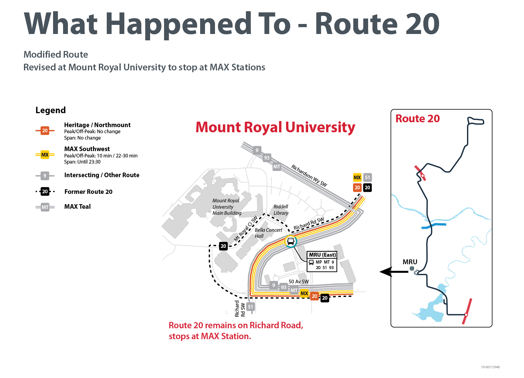
Dotted line = current route
Coloured line = proposed route
(Click to enlarge)
39
What Happened To Route 39: Acadia
This route is proposed to be discontinued and replaced by proposed Routes 99, 106 and 149.
Service in the centre of Acadia will be available on the proposed Route 99, which will replace the existing Route 79 and 80 and follow the same streets between Heritage LRT Station and Southland LRT Station.
Proposed new Route 99 Routing:
From Heritage LRT Station to Southland LRT Station:
- Start at Heritage Station Terminal
- East on Heritage Drive SW
- South on Bonaventure Drive SE
- East on 90 Avenue SE
- East on Acadia Drive SE
- West on Willingdon Boulevard SE
- South on Fairmount Drive SE
- West on Bonaventure Drive SE
- West on Southland Drive SE
- South on Sacramento Drive SW
- End at Southland Station Terminal
From Southland Station to Oakridge:
- Start at Southland Station Terminal
- North on Sacramento Drive SW
- West on Southland Drive SW
- North on Oakfield Drive SW
- West on Oakwood Drive SW
- East on Palliser Drive SW
- East on Southland Drive SW
- South on Sacramento Drive SW
- End at Southland Station Terminal
From Southland Station to Southcentre, Acadia, and Heritage Station:
- Start at Southland Station Terminal
- North on Sacramento Drive SW
- East on Southland Drive SW
- South on Bonaventure Drive SE
- North on Fairmount Drive SE
- East on Willingdon Boulevard SE
- North on Acadia Drive SE
- West on 90 Avenue SE
- North on Bonaventure Drive SE
- West on Heritage Drive SE
- South on Haddon Road SW
- End at Heritage Station Terminal
Service on Southland Drive SE to Southland LRT Station will be provided on Route 106. This route will also continue east to Deerfoot Meadows.
Proposed new Route 106 Routing:
- Start at Southland LRT Station
- East on Southland Drive SE
- North on Blackfoot Trail SE
- East on Heritage Drive SE
- South on Heritage Meadows Road SE
- West on Heritage Meadows Way SE
- North on 11 Street SE
- West on Heritage Drive SE
- South on Blackfoot Trail SE
- West on Southland Drive SE
- End at Southland LRT Station
Key Locations Served:
- Southland LRT Station
- Deerfoot Meadows Shopping Center
Route 106 Service Levels. Proposed to operate every 22 minutes during peak periods, and every 42 minutes at all other times. Service is provided until 18:00 on weekdays, Saturdays and Sundays.
Service on Heritage Drive SE to Heritage LRT Station will be provided by Route 149. This route will also continue east to Deerfoot Meadows and the southeast industrial area.
Proposed new Route 149 Routing:
- Start at Heritage LRT Station
- East on Heritage Drive SE
- East on Glenmore Trail SE
- South on Ogden Road SE, turn around at roundabout at 86 Avenue at South Hill
- North on Ogden Road SE
- East on Glenmore Trail SE
- South on Barlow Trail SE
- East on 90 Avenue SE
- South on 52 Street SE
- East on 94 Avenue SE
- Turnaround in Point Trotter Industrial Park via 106 Avenue
- West on 94 Avenue SE
- North on 52 Street SE
- East on 86 Avenue SE
- South on 60 Street SE
- West on 90 Avenue SE
- North on Barlow Trail SE
- West on Glenmore Trail SE
- South on Ogden Road SE, turn around at roundabout at 86 Avenue at South Hill
- North on Ogden Road SE
- West on Glenmore Trail SE
- West on Heritage Drive SE
- End at Heritage LRT Station
Key areas served:
- Heritage LRT Station
- Heritage Drive Southeast
- Deerfoot Meadows
- South Hill Terminal
- South Foothills Industrial
- Point Trotter Industrial
Route 149 Service Levels. Proposed to operate every 25 minutes during peak periods, and every 35 minutes at all other times. Service is provided until 19:00 on weekdays, and until 18:00 on Saturdays. There will be no service on Sundays.

Dotted line = current route
Coloured line = proposed route
(Click to enlarge)
47
What Happened To Route 47: Lakeview
This route is proposed to be discontinued and replaced by proposed Routes 13 and 93.
Service in Lakeview will be provided on Route 13. Service on Glenmore Trail towards Chinook will be provided on Route 93.
Proposed revised Route 13 Routing:
Northbound:
- Start on Southbound Crowchild Trail SW at 63 Avenue SW
- South on Crowchild Trail SW
- West on 66 Avenue SW
- North on 37 Street SW
- East on Lakeview Drive SW
- South on Lakeview Drive SW
- East on Lancaster Way SW
- South on Lancaster Way SW
- East on 63 Avenue SW
- North on Crowchild Trail SW
- East on 50 Avenue SW
- North on 16 Street SW
- East on 38 Avenue SW
- North on 14 Street SW
- East on 36 Avenue SW
- North on 10 Street SW
- East on Prospect Avenue SW
- North on 8 Street SW
- East on 5 Avenue SW
- South on 1 Street SW, stopping by The Bay
- West on 11 Avenue SW
- South on 8 Street SW
- West on Prospect Avenue SW
- South on Carleton Street SW
- West on 36 Avenue SW
- South on 14 Street SW
- West on 38 Avenue SW
- South on 16 Street SW
- West on 50 Avenue SW
- South on Crowchild Trail SW
- End at Crowchild Trail SW at 63 Avenue SW
Southbound:
- Start on 1 Street SW by The Bay
- South on 1 Street SW
Key Locations Served:
- Lakeview
- 50 Avenue SW
- Altadore
- Mount Royal, Beltline, and Downtown
Route 13 Service Levels. Proposed to operate every 15 minutes during peak periods, and every 28 to 45 minutes at all other times. Service is provided until 23:30 time on weekdays and Saturdays, and until 21:00 on Sundays.
Proposed revised Route 93 Routing:
Westbound:
- Start at Chinook LRT Station
- West on 61 Avenue SW
- South on Macleod Trail
- West on Glenmore Trail SW
- North on Crowchild Trail SW
- West on 50 Avenue SW
- North on Richard Road SW
- West on Richardson Way SW
- Continue West on 46 Avenue SW
- North on 50 Street SW
- West on Richmond Road SW, continues to Coach Hill as the existing Route 93
- Routing from Coach Hill to Westhills is the same as the existing Route 93
- East on Richmond Road SW
- South on 50 Street SW
- East on 46 Avenue SW
- Continue East on Richardson Way SW
- South on Richard Road SW
- East on Mount Royal Gate SW
- South on Crowchild Trail SW
- East on Glenmore Trail SW
- North on Macleod Trail
- East on 61 Avenue SW
- End at Chinook LRT Station.
Eastbound:
Key areas served:
- Coach Hill
- 69 Street LRT Station
- Signal Hill
- Westhills Shopping Centre
- 46 Avenue SW
- Mount Royal University
- Chinook Centre
- Chinook LRT Station
Route 93 Service Levels. Proposed to operate every 15 minutes during peak periods, and every 33 minutes at all other times of day. Service is provided until 24:30 on weekdays, Saturdays and Sundays.

Dotted line = current route
Coloured line = proposed route
(Click to enlarge)
56
What Happened To Route 56: Woodbine
This route is proposed to be revised to connect to Heritage LRT Station via 90 Avenue SW.
Route 56 Routing:
From Anderson to Heritage LRT Station:
- Start at Anderson LRT Station
- Routing from Anderson LRT Station to Woodbine to stay the same as the existing Route 56, until route reaches 24 Street at Southland Drive
- North on 24 Street SW
- East on 90 Avenue SW
- North on 14 Street SW
- East on Heritage DR SW
- End at Heritage LRT Station
- West on Heritage Drive SW
- South on 14 Street SW
- West on 90 Avenue SW
- South on 24 Street SW
- route continues south on 24 Street SW, with routing to Anderson LRT Station via Woodbine to stay the same as the existing Route 56
- End at Anderson LRT Station
From Heritage to Anderson LRT Station:
- Start at Heritage LRT Station
Key Locations Served:
- Anderson LRT Station
- Woodbine and Woodlands
- 24 Street SW
- 90 Avenue SW
- Heritage Park
- Heritage LRT Station
Route 56 service levels. Proposed to operate every 17 minutes during peak periods, and every 35 minutes at all other times. Service is provided until 25:00 on weekdays, and until 24:30 on Saturdays and Sundays.
Service on Southland Drive between 24 Street SW and Southland LRT Station will be provided by Routes 95, 99, 125, and 126. Routes 95 and 126 will travel eastbound on Southland Drive, while Routes 99 and 125 will travel westbound.
Service from Woodbine to Southland Drive will be provided by new MAX Southwest
MAX Southwest Routing:
Northbound:
- Start on 24 Street SW in Woodbine at Woodpark Boulevard SW
- North on 24 Street SW
- East on Southland Drive
- North on Transitway beside 14 Street SW
- North on 14 Street SW
- West on Glenmore Trail SW
- North on Crowchild Trail SW
- West on 50 Avenue SW
- North on Richard Road SW
- North on Crowchild Trail SW
- East on Bow Trail SW, continuing east on 9 Avenue SW
- North on 6 Street SW
- East on 5 Avenue SW – ends near 1 Street SW
Southbound:
- Start on 5 Avenue at 1 Street SW
- South on 1 Street SW
- West on 6 Avenue SW, continuing west on Bow Trail SW
- South on Crowchild Trail SW
- South on Richard Road SW
- East on 50 Avenue SW
- South on Crowchild Trail SW
- East on Glenmore Trail SW
- South on 14 Street SW
- South on Transitway beside 14 Street SW
- West on Southland Drive SW
- South on 24 Street SW
- End at Woodbine on 24 Street SW

Dotted line = current route
Coloured line = proposed route
(Click to enlarge)
79
What Happened To Route 79: Acadia / Oakridge, and Route 80: Oakridge / Acadia
These routes are proposed to be discontinued and replaced by proposed Routes 56, 95, 99, 125 & 126.
Service to Heritage LRT Station and 90 Avenue SW will be provided by Route 56.
Proposed revised Route 56 Routing:
- Start at Anderson LRT Station
- North on Anderson Station Way SW
- West on 109 Avenue SW
- North on Southport Way SW
- East on 109 Avenue SW
- South on Macleod Trail S
- West on Anderson Road DW
- South on Woodpark Boulevard SW
- Continue West on Woodpark Boulevard SW
- South on Woodfield Road SW
- Continue West on Woodfield Road SW
- North on Woodbine Boulevard SW
- Continue East on Woodbine Boulevard SW
- Continue South on Woodbine Boulevard SW
- East on Woodview Drive SW
- North on 24 Street SW
- East on 90 Avenue SW
- North on 14 Street SW
- East on Heritage DR SW
- Enter Heritage LRT Station
- Leave Heritage LRT Station
- West on Heritage Drive SW
- South on 14 Street SW
- West on 90 Avenue SW
- South on 24 Street SW
- West on Woodview Drive SW
- North on Woodbine Boulevard SW
- Continue West on Woodbine Boulevard SW
- South on Woodbine Boulevard SW
- East on Woodfield Road SW
- Continue North on Woodfield Roads SW
- East on Woodpark Boulevard SW
- North on Woodpark Boulevard SW
- East on Anderson Road SW
- North on Macleod Trail S
- West 109 Avenue SE
- South on Southport Way SW
- End at Anderson LRT Station
Key Locations Served:
- Anderson LRT Station
- E.P. Scarlett High School
- 24 Street SW
- Glenmore Landing
- Heritage LRT Station
Route 56 service levels. Proposed to operate every 17 minutes during peak periods, and every 35 minutes at all other times. Service is provided until 25:00 on weekdays, and until 24:30 on Saturdays and Sundays.
Service to South Center, Willow Park, Maple Ridge and Acadia will be provided by route 99. East of Macleod Trail, Route 99 will follow the same routing as the existing Route 79 and 80.
Service to Oakridge and Palliser will be provided by Routes 95 and 99. In these communities, they will operate as a clockwise and counterclockwise loop.
Proposed new Route 95 Routing:
- Start at Southland LRT Station
- West on Southland Drive SW
- North on Palliser Drive SW
- West on Oakwood Drive SW
- South on Oakfield Way SW
- East on Southland Drive SW
- End at Southland LRT Station
Key Locations Served:
- Southland LRT Station
- Southland Leisure Centre
- Oakridge Co-op
- Southland LRT Station
- Southland Leisure Centre
- Oakridge Co-op
- Southland LRT Station
- Southland Leisure Centre
- Oakridge Co-op
- Southland LRT Station
- Southland Leisure Centre
- Oakridge Co-op
Route 95 Service Levels. Proposed to operate every 32 minutes in all service periods. Service provided to 9pm on Weekdays, 6pm on Saturdays, and no service on Sundays.
Proposed new Route 99 Routing:
- Start at Southland LRT Station
- West on Southland Drive SW
- North on Oakfield Drive SW
- West on Oakfield Drive SW
- East on Palliser Drive SW
- East on Southland Drive SW to Southland LRT Station
- Route continues east, proceeding generally as existing Route 79 and 80 until ending at Heritage LRT Station
Key Locations Served:
Route 99 Service levels. Proposed to operate every 18 minutes during peak periods, and every 30 minutes at all other times of day. Service is provided until midnight on weekdays, 11:30pm on Saturday, and 10:15pm on Sundays.
Service to Cedarbrae and Braeside will be provided by Routes 125 and 126. In these communities, they will operate as clockwise and counterclockwise routes.
Proposed new Route 125 Routing:
- Start at Southland LRT Station
- West on Southland Drive SW
- South on Oakfield Drive SW
- West on Cedarille Drive SW
- East on Oakfield Drive SW, continuing east on Braeside Drive SW
- East on Southland Drive SW
- Ends at Southland LRT Station
Key Locations Served:
Route 125 service levels. Proposed to operate every 16 to 30 minutes during peak periods, and every 30 minutes at all other times. Service is provided until midnight on weekdays, and 11:30pm on Saturday and Sunday.
Proposed new Route 126 Routing:
- Start at Southland LRT Station
- West on Southland Drive SW
- South on Braeside Drive, and continuing west on Oakfield Drive SW
- South on Cedarille Drive SW
- North on Oakfield Drive SW
- East on Southland Drive SW
- Ends at Southland LRT Station
Key Locations Served:
Route 126 service levels. Proposed to operate every 16 to 30 minutes during peak periods, and every 30 minutes at all other times. Service is provided until 9pm on weekdays, 6pm on Saturdays, and no service on Sundays.

Dotted line = current route
Coloured line = proposed route
(Click to enlarge)
80
What Happened To Route 79: Acadia / Oakridge, and Route 80: Oakridge / Acadia
These routes are proposed to be discontinued and replaced by proposed Routes 56, 95, 99, 125 & 126.
Service to Heritage LRT Station and 90 Avenue SW will be provided by Route 56.
Proposed revised Route 56 Routing:
- Start at Anderson LRT Station
- North on Anderson Station Way SW
- West on 109 Avenue SW
- North on Southport Way SW
- East on 109 Avenue SW
- South on Macleod Trail S
- West on Anderson Road DW
- South on Woodpark Boulevard SW
- Continue West on Woodpark Boulevard SW
- South on Woodfield Road SW
- Continue West on Woodfield Road SW
- North on Woodbine Boulevard SW
- Continue East on Woodbine Boulevard SW
- Continue South on Woodbine Boulevard SW
- East on Woodview Drive SW
- North on 24 Street SW
- East on 90 Avenue SW
- North on 14 Street SW
- East on Heritage DR SW
- Enter Heritage LRT Station
- Leave Heritage LRT Station
- West on Heritage Drive SW
- South on 14 Street SW
- West on 90 Avenue SW
- South on 24 Street SW
- West on Woodview Drive SW
- North on Woodbine Boulevard SW
- Continue West on Woodbine Boulevard SW
- South on Woodbine Boulevard SW
- East on Woodfield Road SW
- Continue North on Woodfield Roads SW
- East on Woodpark Boulevard SW
- North on Woodpark Boulevard SW
- East on Anderson Road SW
- North on Macleod Trail S
- West 109 Avenue SE
- South on Southport Way SW
- End at Anderson LRT Station
Key Locations Served:
- Anderson LRT Station
- E.P. Scarlett High School
- 24 Street SW
- Glenmore Landing
- Heritage LRT Station
Route 56 service levels. Proposed to operate every 17 minutes during peak periods, and every 35 minutes at all other times. Service is provided until 25:00 on weekdays, and until 24:30 on Saturdays and Sundays.
Service to South Center, Willow Park, Maple Ridge and Acadia will be provided by route 99. East of Macleod Trail, Route 99 will follow the same routing as the existing Route 79 and 80.
Service to Oakridge and Palliser will be provided by Routes 95 and 99. In these communities, they will operate as a clockwise and counterclockwise loop.
Proposed new Route 95 Routing:
- Start at Southland LRT Station
- West on Southland Drive SW
- North on Palliser Drive SW
- West on Oakwood Drive SW
- South on Oakfield Way SW
- East on Southland Drive SW
- End at Southland LRT Station
Key Locations Served:
- Southland LRT Station
- Southland Leisure Centre
- Oakridge Co-op
- Southland LRT Station
- Southland Leisure Centre
- Oakridge Co-op
- Southland LRT Station
- Southland Leisure Centre
- Oakridge Co-op
- Southland LRT Station
- Southland Leisure Centre
- Oakridge Co-op
Route 95 Service Levels. Proposed to operate every 32 minutes in all service periods. Service provided to 9pm on Weekdays, 6pm on Saturdays, and no service on Sundays.
Proposed new Route 99 Routing:
- Start at Southland LRT Station
- West on Southland Drive SW
- North on Oakfield Drive SW
- West on Oakfield Drive SW
- East on Palliser Drive SW
- East on Southland Drive SW to Southland LRT Station
- Route continues east, proceeding generally as existing Route 79 and 80 until ending at Heritage LRT Station
Key Locations Served:
Route 99 Service levels. Proposed to operate every 18 minutes during peak periods, and every 30 minutes at all other times of day. Service is provided until midnight on weekdays, 11:30pm on Saturday, and 10:15pm on Sundays.
Service to Cedarbrae and Braeside will be provided by Routes 125 and 126. In these communities, they will operate as clockwise and counterclockwise routes.
Proposed new Route 125 Routing:
- Start at Southland LRT Station
- West on Southland Drive SW
- South on Oakfield Drive SW
- West on Cedarille Drive SW
- East on Oakfield Drive SW, continuing east on Braeside Drive SW
- East on Southland Drive SW
- Ends at Southland LRT Station
Key Locations Served:
Route 125 service levels. Proposed to operate every 16 to 30 minutes during peak periods, and every 30 minutes at all other times. Service is provided until midnight on weekdays, and 11:30pm on Saturday and Sunday.
Proposed new Route 126 Routing:
- Start at Southland LRT Station
- West on Southland Drive SW
- South on Braeside Drive, and continuing west on Oakfield Drive SW
- South on Cedarille Drive SW
- North on Oakfield Drive SW
- East on Southland Drive SW
- Ends at Southland LRT Station
Key Locations Served:
Route 126 service levels. Proposed to operate every 16 to 30 minutes during peak periods, and every 30 minutes at all other times. Service is provided until 9pm on weekdays, 6pm on Saturdays, and no service on Sundays.
Dotted line = current route
Coloured line = proposed route
(Click to enlarge)
81
What Happened To Route 81: Macleod Trail
This route is proposed to be modified. It will be revised to serve 4A Street SW and 75 Avenue SW in the community of Kingsland, and to circle around Southcentre Mall via Bonaventure Drive SE, Anderson Road SE, and Macleod Trail SE.
Route north of Chinook Station will remain the same as today. Service on this route south of Anderson Road is proposed to be discontinued, with alternative service provided by Route 35 on Lake Bonavista Drive, and by Canyon Meadows CTrain Station.
Route 81 Routing:
Southbound:
- From Chinook LRT Station
- West on 61 Avenue SW
- South on Macleod Trail SW
- West on 67 Avenue SW
- South on 4A Street SW
- East on 71 Avenue SW
- South on Macleod Trail S
- West on 75 Avenue SW
- South on Elbow Drive SW
- East on Heritage Drive SW
- Stop at Heritage LRT Station
- East on Heritage Drive SW
- South on Macleod Trail S
- West on Southland Drive SW
- Stop at Southland LRT Station
- East on Southland Drive SW
- South on Southport Road SW
- East on Willow Park Drive SE
- South on Bonaventure Drive SE
- West on Anderson Road SE
- North on Macleod Trail S
- West on Southport Road SW, continuing to north on Southport Road SW
- West on Southland Drive SW
- End at Southland LRT Station
Northbound:
- Start at Southland LRT Station
- East on Southland Drive SW
- North on Macleod Trail S
- West on Heritage Drive SW
- Stop at Heritage LRT Station
- West on Heritage Drive SW
- North on Elbow Drive SW
- East on 75 Avenue SW
- North on Macleod Trail S
- West on 71 Avenue SW
- North on 4A Street SW
- East on Glenmore Trail SW
- North on Macleod Trail SW
- East on 61 Avenue SW
- Stop at Chinook LRT Station
- North on 1A Street SW
- East on 58 Avenue SW
- North on 3 Street SE
- West on 50 Avenue SE
- South on 4 Street SW, continuing to south on Macleod Trail SW
- East on 61 Avenue SW
- End at Chinook LRT Station
Key Locations Served:
- Manchester Industrial
- Chinook Station and Chinook Centre
- Kingsland
- Heritage Station
- Macleod Trail
- Southland Station
- Southcentre Mall
Route 81 service levels: Proposed to operate every 32 minutes on weekdays until approximately 7pm, and every 45 minutes on Saturdays until 7pm
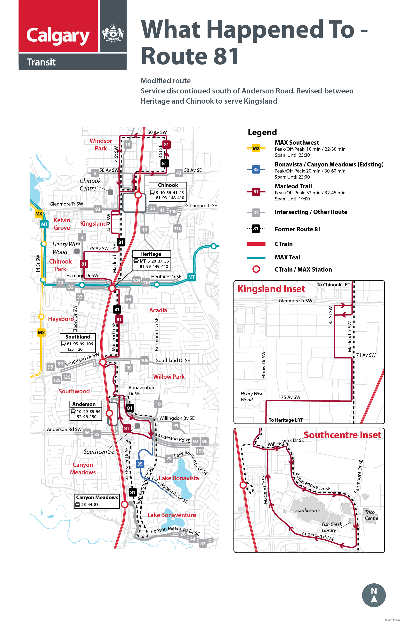
Dotted line = current route
Coloured line = proposed route
(Click to enlarge)
84
What Happened To Route 16 – Palliser and Route 84 - Palliser
These routes are proposed to be discontinued and replaced by proposed Routes 95, 99, 125, and 126.
Service to the Oakridge, Palliser, and Pump Hill communities will be provided on Routes 95 and 99. In these communities they operate as a clockwise and counterclockwise loop.
Proposed new Route 95 Routing:
- Start at Southland LRT Station
- West on Southland Drive SW
- North on Palliser Drive SW
- West on Oakwood Drive SW
- South on Oakfield Way SW
- East on Southland Drive SW
- End at Southland LRT Station
Key Locations Served:
- Southland LRT Station
- Southland Leisure Centre
- Oakridge Co-op
- Southland LRT Station
- Southland Leisure Centre
- Oakridge Co-op
- Southland LRT Station
- Southland Leisure Centre
- Oakridge Co-op
- Southland LRT Station
- Southland Leisure Centre
- Oakridge Co-op
Route 95 Service Levels. Proposed to operate every 32 minutes in all service periods. Service provided to 9pm on Weekdays, 6pm on Saturdays, and no service on Sundays.
Proposed new Route 99 Routing:
- Start at Southland LRT Station
- West on Southland Drive SW
- North on Oakfield Drive SW
- West on Oakfield Drive SW
- East on Palliser Drive SW
- East on Southland Drive SW to Southland LRT Station
Route 99 also continues to east, replacing the existing Route 79 and 80 on the same routing to Heritage LRT Station and then returning the same way
Key Locations Served:
Route 99 Service levels. Proposed to operate every 18 minutes during peak periods, and every 30 minutes at all other times of day. Service is provided until midnight on weekdays, 11:30pm on Saturday, and 10:15pm on Sundays.
Service to Cedarbrae will be provided on Routes 125 and 126, which operate as a clockwise and counterclockwise loop.
Proposed new Route 125 Routing:
- Start at Southland LRT Station
- West on Southland Drive SW
- South on Oakfield Drive SW
- West on Cedarille Drive SW
- East on Oakfield Drive SW, continuing east on Braeside Drive SW
- East on Southland Drive SW
- Ends at Southland LRT Station
Key Locations Served:
Route 125 service levels. Proposed to operate every 16 to 30 minutes during peak periods, and every 30 minutes at all other times. Service is provided until midnight on weekdays, and 11:30pm on Saturday and Sunday.
Proposed new Route 126 Routing:
- Start at Southland LRT Station
- West on Southland Drive SW
- South on Braeside Drive, and continuing west on Oakfield Drive SW
- South on Cedarille Drive SW
- North on Oakfield Drive SW
- East on Southland Drive SW
- Ends at Southland LRT Station
Key Locations Served:
Route 126 service levels. Proposed to operate every 16 to 30 minutes during peak periods, and every 30 minutes at all other times. Service is provided until 9pm on weekdays, 6pm on Saturdays, and no service on Sundays.
Dotted line = current route
Coloured line = proposed route
(Click to enlarge)
93
What Happened To Route 93: Coach Hill - Westbrook
This route is proposed to be modified. It will be revised to serve 46 Avenue SW, Mount Royal University, Chinook Centre, and Chinook Station.
Route between Coach Hill and Westhills will remain the same as today. Alternative service on 45 Street SW and Spruce Drive between Westhills and Westbrook to be provided by new Route 45.
Proposed revised Route 93 Routing:
Eastbound:
- From Coach Hill, 69 Street Station, and Signal Hill
- Eastbound Richmond Road SW
- Southbound 50 Street SW
- Eastbound 46 Avenue SW
- Eastbound Richardson Way SW
- Southbound Richard Road SW
- Eastbound Mount Royal Gate SW
- Southbound Crowchild Trail SW
- Eastbound Glenmore Trail SW
- Northbound Macleod Trail SW
- Eastbound 61 Avenue SW
- Southbound 1A Street SW
- End at Chinook LRT Station
Westbound:
- Start at Chinook LRT Station
- Northbound 1A Street SW
- Westbound 61 Avenue SW
- Southbound Macleod Trail SW
- Westbound Glenmore Trail SW
- Northbound Crowchild Trail SW
- Westbound Mount Royal Gate SW
- Northbound Richard Road SW
- Westbound Richardson Way SW
- Westbound 46 Avenue SW
- Northbound 50 Street SW
- Westbound Richmond Road SW
- To Signal Hill, 69 Street Station, and Coach Hill
Key Locations Served:
- Coach Hill and Patterson
- 69 Street Station
- Signal Hill
- Westhills Shopping Centre
- 46 Avenue SW
- Mount Royal University
- Chinook Centre and Chinook Station
Route 93 service levels: Proposed to operate every 15 minutes during peak on weekdays, and every 33 minutes all other times. Service provided until 12:30 AM every day.
Service on 45 Street SW and Spruce Drive SW between Westhills and Westbrook will be provided by the new Route 45.
Proposed new Route 45 routing:
Eastbound:
- From Westhills on Stewart Green SW
- Northbound Stewart Green SW
- Eastbound Richmond Road SW
- Northbound 45 Street SW – stopping at 45 Street Station
- Westbound Windermere Road SW
- Eastbound Spruce Drive SW
- Southbound Spruce Drive SW
- Southbound 33 Street SW
- End at Westbrook LRT Station
Westbound:
- Start at Westbrook LRT Station
- Northbound 33 Street SW
- Northbound Spruce Drive SW
- Westbound Spruce Drive SW
- Southbound 45 Street SW – stopping at 45 Street Station
- Westbound Richmond Road SW
- Southbound Stewart Green SW
- End at Westhills on Stewart Green SW
Key locations served:
- Westhills Shopping Centre
- 45 Street SW and 45 Street Station
- Spruce Drive SW
- Westbrook Mall and Westbrook Station
Route 45 service levels: Proposed to operate every 17 minutes during peak on weekdays, and every 32 minutes all other times. Service provided until 12:30 AM on weekdays and Saturdays, and until 11:30 PM on Sundays.
Dotted line = current route
Coloured line = proposed route
(Click to enlarge)
94
What Happened To Route 94: Strathcona - Westbrook
This route is proposed to be modified. It will be revised to serve Strathcona, 69 Street Station, Sirocco Station, Signal Hill, and Westhills.
Route north of Westhills will remain the same as today. Alternative service on 51 Street SW and 26 Avenue SW is provided by the revised Route 6.
Proposed revised Route 94 Routing:
- From Strathcona via 69 Street Station, Sirocco Station, and Signal Hill Drive
- Southbound Sierra Morena Road SW
- Eastbound Sierra Morena Boulevard SW
- Eastbound Signal Hill Centre
- Southbound Stewart Green SW
- Continue around Stewart Green SW
- Westbound Richmond Road SW
- Northbound Sierra Morena Boulevard SW
- Northbound Sierra Morena Road SW
- To Strathcona via Signal Hill Drive, Sirocco Station, and 69 Street Station
Key Locations Served:
- Strathcona
- 69 Street Station and Sirocco Station
- Signal Hill
- Westhills Shopping Centre
Route 94 service levels: Proposed to operate every 20 minutes on weekdays during peak, and every 32 minutes at all other times. Service provided until 12:30 AM every day.
Service on 51 Street SW and 26 Avenue SW between Westhills and 37 Street SW will be provided by the revised Route 6.
Proposed revised Route 6 routing:
Eastbound:
- Start at Westhills on Stewart Green SW
- East on Richmond Road SW
- North on 51 Street SW
- East on 26 Avenue SW
- North on 17A Street SW
- East on 17 Avenue SW
- North on 1 Street SW – Stop by The Bay
- North on 1 Street SW
- West on 6 Avenue SW
- South on 8 Street SW
- West on 11 Avenue SW
- South on 14 Street SW
- West on 17 Avenue SW
- South on 17A Street SW
- West on 26 Avenue SW
- South on 51 Street SW
- West on Richmond Road SW
- South on Stewart Green SW
- End at Westhills
Westbound:
Key Locations Served:
- Westhills Shopping Centre
- 51 Street SW
- 26 Avenue SW
- 17 Avenue SW
- Beltline
- Downtown
Route 6 service levels: Proposed to operate every 15 minutes during peak periods, every 23 minutes during weekday mid-days and evenings, and every 25 to 30 minutes on weekends. Service is provided until approximately midnight on weekdays, and 11:30 PM on weekends.
Dotted line = current route
Coloured line = proposed route
(Click to enlarge)
112
What Happened To Route 112: Sarcee Road
This route is proposed to be discontinued and replaced by proposed Routes 22, 93 and 132.
Service between Westhills and Downtown will be provided on Route 22 via Richmond Road. Service on 46 Avenue SW is proposed on Route 93 between Westhills and connecting to Chinook LRT Station. Service on Sarcee Road is proposed on Route 132 connecting 45 Street SW in Glamorgan to Westbrook LRT Station via 29 Street SW.
Proposed new Route 22 Routing:
Eastbound:
- Start on Stewart Green SW at Westhills
- East on Richmond Road SW, continuing east on 33 Avenue SW
- North on Crowchild Trail
- East on Bow Trail, continuing east on 9 Avenue SW
- North on 1 Street SW – stop by The Bay
Westbound:
- Start on 1 Street SW by The Bay
- North on 1 Street SW
- West on 6 Avenue SW, continuing west on Bow Trail SW
- South on Crowchild Trail SW
- West on 33 Avenue SW, continuing west on Richmond Road SW
- South on Stewart Green SW
- End at Westhills
Route 22 service levels. Proposed to operate every 12 minutes during weekday peak periods and every 30 minutes in all other service periods. Service is provided until approximately 12:30 am on weekdays, 11:30pm on Saturdays, and 11:00pm on Sundays.
Proposed revised Route 93 routing:
Eastbound:
- From Coach Hill to Westhills as on existing Route 93
- East on Richmond Road SW
- South on 50 Street SW
- East on 46 Avenue SW, continuing east on Richardson Way SW and stopping at MRU bus terminal
- West on Richard Road SW
- East on 50 Avenue SW
- South on Crowchild Trail
- East on Glenmore Trail and proceeding to Chinook LRT Station
Westbound:
- From Chinook LRT Station
- West on Glenmore Trail SW
- North on Crowchild Trail SW
- West on 50 Avenue SW
- North on Richard Road SW
- West on Richardson Way SW, stopping at MRU bus terminal
- West on Richardson Way, continuing west on 46 Avenue SW
- North on 50 Street SW
- West on Richmond Road SW
- Proceeding through to Coach Hill as on existing Route 93
Key Locations served:
- Westhills shopping centre
- Mount Royal University bus terminal
- Mount Royal University BRT Station
- Lincoln Park
- Chinook Centre
- Chinook LRT Station
Route 93 service levels. Proposed to operate every 15 minutes during weekday peak periods and every 33 minutes in all other service periods. Service is provided until approximately 12:30am every day.
Proposed Route 132 routing:
- Start at Westbrook LRT Station
- South on 33 Street SW
- East on 17 Avenue SW
- South on 29 Street SW, continuing south on Sarcee Road SW
- West on Richardson Way SW, continuing west on 46 Avenue SW
- South on 43 Street SW
- West on Gordon Drive SW
- South on 43 Street SW
- West on Galbraith Drive SW, continuing north on Galbraith Drive SW
- West on 49 Avenue SW
- North on 45 Street SW
- East on 46 Avenue SW, continuing east on Richardson Way SW
- North on Sarcee Road SW, continuing north on 29 Street SW
- West on 17 Avenue SW
- North on 33 Street SW
- Ends at Westbrook LRT Station
Key Locations Served:
- Westbrook LRT Station
- Killarney Aquatic & Recreation Centre
- Grace Lutheran Manor
- Carewest Royal Park
- Mount Royal University
- Silvera Glamorgan
Route 132 service levels. Proposed to operate every 17 minutes during peak periods, and every 32 minutes at all other times. Service is provided until 24:30 on weekdays, midnight on Saturday and 11pm on Sunday.

Dotted line = current route
Coloured line = proposed route
(Click to enlarge)
149
What Happened To Route 149 – Point Trotter
Proposed modified route. The existing Route 149 is proposed to be extended west from South Hill to Heritage LRT Station via Deerfoot Meadows.
Proposed revised Route 149 routing:
- Start at Heritage LRT Station
- East on Heritage Drive SE
- East on Glenmore Trail SE
- South on Ogden Road SE, turn around at roundabout at 86 Avenue at South Hill
- North on Ogden Road SE
- East on Glenmore Trail SE
- South on Barlow Trail SE
- East on 90 Avenue SE
- South on 52 Street SE
- East on 94 Avenue SE
- Turnaround in Point Trotter Industrial Park via 106 Avenue
- West on 94 Avenue SE
- North on 52 Street SE
- East on 86 Avenue SE
- South on 60 Street SE
- West on 90 Avenue SE
- North on Barlow Trail SE
- West on Glenmore Trail SE
- South on Ogden Road SE, turn around at roundabout at 86 Avenue at South Hill
- North on Ogden Road SE
- West on Glenmore Trail SE
- West on Heritage Drive SE
- End at Heritage LRT Station
Key areas served:
- Heritage LRT Station
- Heritage Drive Southeast
- Deerfoot Meadows
- South Hill Terminal
- South Foothills Industrial
- Point Trotter Industrial
Route 149 service levels. Proposed to operate every 25 minutes during weekday peak periods, and every 35 minutes during all other service periods. Service to be provide until 7pm on weekdays, until 6pm on Saturdays, and no service on Sundays.

Dotted line = current route
Coloured line = proposed route
(Click to enlarge)
302
What Happened To Route 302 – BRT Southeast
Proposed modified route. The existing Route 302 is proposed to be revised in East Village. Routing towards downtown to be revised to use 9 Avenue SE instead of 6 Street and 6 Avenue SE.
Proposed revised Route 302 routing:
Northbound
- Routing between South Health Campus and Inglewood has no change
- Arriving from Inglewood via 9 Avenue SE, continuing west on 9 Avenue SE
- North on 3 Street SE
- West on 6 Avenue SE
- South on 5 Street SW, ending at 5 Street at 7 Avenue SW
Southbound
- Start from 5 Street at 7 Avenue SW
- South on 5 Street SW
- East on 9 Avenue SE, continuing into Inglewood
- Rest of route to South Health Campus has no change.
Key areas served:
- Downtown
- Inglewood
- Highfield Industrial
- Ogden
- Quarry Park
- Douglas Glen
- New Brighton
- McKenzie Towne
- Mahogany
- Auburn Bay
- Seton
- South Health Campus
Route 302 service levels. No change proposed to frequency or service span.

Dotted line = current route
Coloured line = proposed route
(Click to enlarge)
411
What Happened To Route 411: East Calgary
This route is proposed to be discontinued. Service to be replaced by proposed Route 101. The proposed route will serve the same streets in Inglewood, and revised routing through downtown and East Village.
Proposed new Route 101:
Westbound:
- Start at cul-de-sac at east end of 28 Avenue SE in Inglewood
- North on 17 Street SE, continuing North on 20 Street SE
- West on 9 Avenue SE
- North on 6 Street SE
- West on 6 Avenue SE, continuing west on 6 Avenue SW
- South on 5 Street SW
- East on 9 Avenue SW
- North on 1 Street SW, stopping by The Bay
- Start on 1 Street SW by The Bay
- North on 1 Street SW
- East on 5 Avenue SW, continuing east on 5 Avenue SE
- South on 3 Street SE
- East on 6 Avenue SE
- South on 6 Street SE
- East on 9 Avenue SE
- South on 17 Street SE
- End at cul-de-sac at east end of 28 Avenue SE in Inglewood
Eastbound:
Key Locations Served:
- Alice Bisset Place
- 9 Avenue SE MAX station
- 9 Avenue SE Inglewood
- Fort Calgary
- The Core Shopping Centre
- The Bay
- Downtown
Route 101 service levels. Proposed to operate every 22 minutes during weekday peak periods, and every 42 minutes during all other service periods. Service is provided until approximately 9pm on weekdays, and to 6:30pm on weekends.
Dotted line = current route
Coloured line = proposed route
(Click to enlarge)
414
What Happened To Route 414: 14 Street Crosstown
This route is proposed to be discontinued. Service between North Haven and Lions Park will be provided by proposed Route 141. Service between Lions Park and 17 Avenue SW will be provided on proposed Route 51. Route 51 will then continue south to Marda Loop, Mount Royal University, and Garrison Green.
Proposed Routes 51 and 141 will be connected together at Lions Park. So trips travelling past Lions Park can stay on the same bus to continue through.
Proposed new Route 141 routing:
- Start at Lions Park LRT station
- East on 14 Avenue NW
- North on 14 Street NW
- East on North Haven Drive NW
- North on North Haven Drive NW
- West on 48 Avenue NW
- South on Niven Road NW
- West on Norquay Drive NW
- South on Norquay Drive NW
- West on North Haven Drive NW
- South on 14 Street NW
- West on 16 Avenue NW
- South on 19 Street NW
- East on 14 Avenue NW
- End at Lions Park LRT station
Key Locations Served:
- Lions Park LRT station
- North Hill Mall
- Confederation Park
- Nose Hill Park
Route 141 service levels. Will operate every 30 minutes during weekday peak periods, and every 52 minutes during all other service periods. Service is provided until approximately 6:30pm on weekdays, and to 6:30pm on weekends.
Proposed new Route 51 Routing:
- Start at Lions Park LRT Station
- East on 14 Avenue NW
- South on 14 Street NW
- West on 33 Avenue NW
- South on Crowchild Trail NW
- South on Richard Road SW
- East on Peacekeepers Way SW
- South on Peacekeepers Way SW
- East on Dallaire Avenue SW
- North on Forand Street SW
- West on Peacekeepers Drive SW
- South on Peacekeepers Drive SW
- West on Peacekeepers Way SW
- North on Richard Road SW
- North on Crowchild Trail SW
- East on 33 Avenue SW
- North on 14 Street SW
- West on 16 Avenue NW
- South on 19 Street NW
- East on 14 Avenue NW
- End at Lions Park LRT Station
Key Locations served:
- Lions Park LRT Station
- North Hill Mall
- SAIT
- Kensington
- 14 Street SW
- Marda Loop
- Mount Royal University
- Garrison Green
Route 51 service levels. Proposed to operate every 30 minutes during peak periods, and every 52 minutes during all other service periods. Service is provided until approximately 6:30pm on all days.

Dotted line = current route
Coloured line = proposed route
(Click to enlarge)
PROPOSED ROUTES
Click on the route number to provide your comments below.
6
Proposed Route 6 – Killarney 26 Avenue
Proposed modified route. Serving Westhills shopping centre, Richmond Terminal, 51 Street SW, 26 Avenue SW, 17 Avenue SW, Beltline, and Downtown
Route 6 Routing:
Eastbound:
- Start at Westhills on Stewart Green SW
- East on Richmond Road SW
- North on 51 Street SW
- East on 26 Avenue SW
- North on 17A Street SW
- East on 17 Avenue SW
- North on 1 Street SW – Stop by The Bay
- North on 1 Street SW
- West on 6 Avenue SW
- South on 8 Street SW
- West on 11 Avenue SW
- South on 14 Street SW
- West on 17 Avenue SW
- South on 17A Street SW
- West on 26 Avenue SW
- South on 51 Street SW
- West on Richmond Road SW
- South on Stewart Green SW
- End at Westhills
Westbound:
Route 6 service levels. Proposed to operate every 15 minutes during peak periods, every 23 minutes during mid-days and evenings, and every 25 to 30 minutes on weekends. Service is provided until approximately midnight on weekdays, and 11:30pm on weekends.

(Click to enlarge)
7
Proposed Route 7 – Marda Loop
Proposed modified route. Serving 54 Avenue Terminal, 20 Street SW, Marda Loop, 14 Street SW, Beltline, and Downtown
Route 7 routing:
The bus routing south of 17 Avenue SW will remain the same as today.
- From Marda Loop via 14 Street SW
- North on 14 Street SW
- East on 12 Avenue SW
- North on 8 Street SW
- East on 5 Avenue SW
- South on 1 Street SW – stop by The Bay
- West on 17 Avenue SW
- South on 14 Street SW – continue to Marda Loop as today
Route 7 service levels. Proposed to operate with the same frequency and hours of operation as today.

(Click to enlarge)
13
Proposed Route 13 – Altadore
Proposed modified route. Serving Lakeview, 54 Avenue MAX Station, 50 Avenue SW, Altadore, Mount Royal community, Beltline, and Downtown
Proposed Route 13 Routing:
Northbound:
- Start at Crowchild Trail and 63 Avenue SW
- South on Crowchild Trail SW
- West on 66 Avenue SW
- North on 37 Street SW
- East on Lakeview Drive SW
- East on Lancaster Way SW
- East on 63 Avenue SW
- North on Crowchild Trail SW
- East on 50 Avenue SW
- North on 16 Street SW
- East on 38 Avenue SW
- East on 36 Avenue SW
- North through Mount Royal community along 10 Street SW
- North on 8 Street SW
- East on 5 Avenue SW
- South on 1 Street SW – stop by the Bay
Southbound:
- Start on 1 Street SW by the Bay
- South on 1 Street SW
- West on 11 Avenue SW
- South on 8 Street SW
- South through Mount Royal community along Carleton Street SW
- West on 36 Avenue SW
- West on 38 Avenue SW
- South on 16 Street SW
- West on 50 Avenue SW
- South on Crowchild Trail SW
- End in Lakeview at Crowchild Trail and 63 Avenue SW.
Route 13 service levels. Proposed to operate every 15 minutes during peak periods, every 30 minutes during mid-day periods, and every 30 to 45 minutes on evenings and weekends. Service is provided until approximately 11:30pm on weekdays and Saturdays, and 9:00pm on Sundays.

(Click to enlarge)
20
Route 20 – Northmount / Heritage
Proposed modified route. Service revised at Mount Royal University.
Proposed Route 20 routing:
- Service between 78 Avenue NW and Mount Royal University will remain the same as today
- Service between Mount Royal University and Heritage LRT Station will remain the same as today.
- At Mount Royal University the bus will stay on Richard Road SW and stop at the MAX Stations.
- Route will not travel into MRU via Mount Royal Circle SW

(Click to enlarge)
22
Proposed Route 22 – Richmond Road
Proposed new route. Serving Westhills shopping centre, Richmond Road, Crowchild Trail, and Downtown.
Proposed Route 22 routing:
Eastbound:
- Start on Stewart Green SW at Westhills
- East on Richmond Road SW, continuing east on 33 Avenue SW
- North on Crowchild Trail
- East on Bow Trail, continuing east on 9 Avenue SW
- North on 1 Street SW – stop by The Bay
Westbound:
- Start on 1 Street SW by The Bay
- North on 1 Street SW
- West on 6 Avenue SW, continuing west on Bow Trail SW
- South on Crowchild Trail SW
- West on 33 Avenue SW, continuing west on Richmond Road SW
- South on Stewart Green SW
- End at Westhills
Route 22 service levels. Proposed to operate every 12 minutes during weekday peak periods and every 30 minutes in all other service periods. Service is provided until approximately 12:30 am on weekdays, 11:30pm on Saturdays, and 11:00pm on Sundays.

(Click to enlarge)
45
Proposed Route 45: 45 Street SW
Proposed new route. Serving Westhills Shopping Centre, 45 Street SW, 45 Street LRT Station, Westgate, Wildwood, Spruce Cliff, Westbrook Mall, and Westbrook LRT Station
Route 45 routing:
Eastbound:
- From Westhills on Stewart Green SW
- North on Stewart Green SW
- East on Richmond Road SW
- North on 45 Street SW – stopping at 45 Street Station
- West on Windermere Road SW
- East on Spruce Drive SW
- South on 33 Street SW
- Westbrook Station Terminal
Westbound:
- Westbrook Station Terminal
- North on 33 Street SW
- North on Spruce Drive SW
- South on 45 Street SW – stopping at 45 Street Station
- West on Richmond Road SW
- South on Stewart Green SW
- Route ends at Westhills on Stewart Green SW
Route 45 service levels: Proposed to operate every 17 minutes during peak on weekdays, and every 32 minutes all other times. Service provided until 12:30 AM on weekdays and Saturdays, and until 11:30 PM on Sundays.

(Click to enlarge)
51
Proposed Route 51: Garrison Green / Lions Park
Proposed new route. Serving Garrison Green, Mount Royal University, Marda Loop, 14 Street SW, Kensington, SAIT, North Hill Mall, and Lions Park LRT Station.
Route 51 and 141 are connected at Lions Park LRT Station. Route 51 buses arriving at this station will turn into Route 141 to continue north on 14 Street NW. Route 141 buses arriving at this station will turn into Route 51 to continue south on 14 Street NW.
Key areas served:
- Garrison Green
- Mount Royal University
- Marda Loop, 14 Street SW
- Kensington
- SAIT
- North Hill Mall
- Lions Park LRT Station
Route 51 Routing:
- Start at lions Park LRT Station
- East on 14 Avenue NW
- South on 14 Street NW
- Continue South on 14 Street SW
- West on 33 Avenue SW
- South on Crowchild Trail SW
- West on Richard Road SW
- Continue South on Richard Road SW
- East on Peacekeepers Way SW
- South on Peacekeepers Way SW
- East on Dallaire Avenue SW
- North on Forand Street SW
- West on Peacekeepers Drive SW
- South on Peacekeepers Way SW
- West on Peacekeepers Way SW
- North on Richard Road SW
- Continue West on Richard Road SW
- North on Crowchild Trail SW
- East on 33 Avenue SW
- North on 14 Street SW
- Continue North on 14 Street NW
- West on 14 Avenue NW
- End at Lions Park LRT Station
Route 51 Service Levels. Proposed to operate every minutes during peak periods, and every 52 minutes at all other times. Service is provided until 18:30 on weekdays, Saturdays and Sundays.
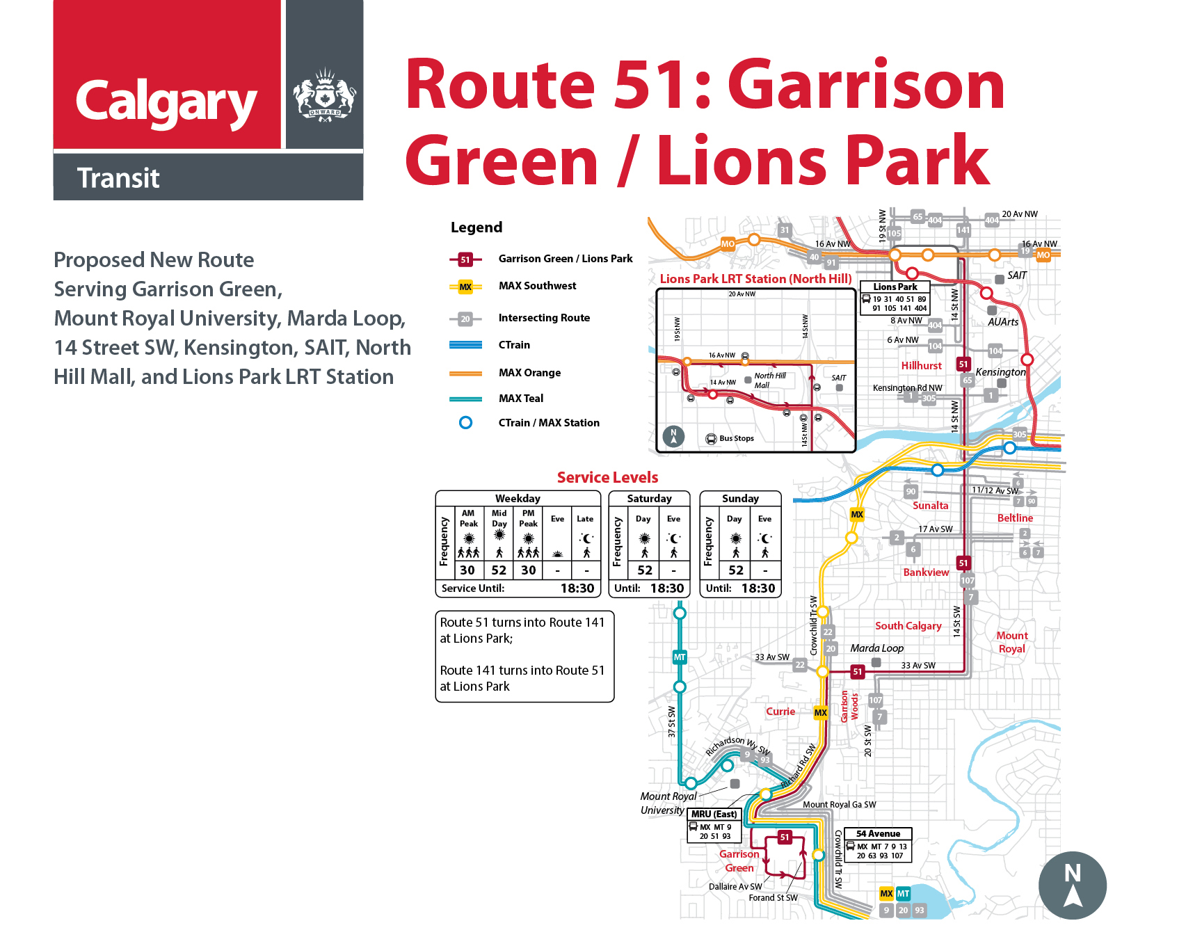
(Click to enlarge)
56
Proposed Route 56: Woodbine
Proposed modified route. Serving Anderson LRT Station, Woodbine, Woodlands, 90 Avenue SW, 24 Street SW, Heritage Park, and Heritage LRT Station
Route 56 Routing:
Northbound:
- Start at Anderson LRT Station
- North on Anderson Station Way SW
- West on 109 Avenue SW
- North on Southport Way SW
- East on 109 Avenue SW
- South on Macleod Trail S
- West on Anderson Road DW
- South on Woodpark Boulevard SW
- Continue West on Woodpark Boulevard SW
- South on Woodfield Road SW
- Continue West on Woodfield Road SW
- North on Woodbine Boulevard SW
- Continue East on Woodbine Boulevard SW
- Continue South on Woodbine Boulevard SW
- East on Woodview Drive SW
- North on 24 Street SW
- East on 90 Avenue SW
- North on 14 Street SW
- East on Heritage DR SW
- End at Heritage LRT Station
- Start at Heritage LRT Station
- West on Heritage Drive SW
- South on 14 Street SW
- West on 90 Avenue SW
- South on 24 Street SW
- West on Woodview Drive SW
- North on Woodbine Boulevard SW
- Continue West on Woodbine Boulevard SW
- South on Woodbine Boulevard SW
- East on Woodfield Road SW
- Continue North on Woodfield Roads SW
- East on Woodpark Boulevard SW
- North on Woodpark Boulevard SW
- East on Anderson Road SW
- North on Macleod Trail S
- West 109 Avenue SE
- South on Southport Way SW
- End at Anderson LRT Station
Southbound:
Route 56 service levels. Proposed to operate every 17 minutes during peak periods, and every 35 minutes at all other times. Service is provided until 25:00 on weekdays, and until 24:30 on Saturdays and Sundays.

(Click to enlarge)
81
Proposed Route 81 – Macleod Trail
Proposed modified route. Serving Chinook LRT Station, Chinook Centre, Manchester Industrial, Kingsland, Heritage LRT Station, Macleod Trail, Southland LRT Station, and Southcentre Mall.
Proposed revised Route 81 routing:
Southbound:
- Start at Chinook LRT station
- West on 61 Avenue SE
- South on Macleod Trail SW
- West on 67 Avenue SW
- South on 4a Street SW
- East on 71 Avenue SW
- South on Macleod Trail SW
- West on 75 Avenue SW
- South on Elbow Drive SW
- East on Heritage Drive SW
- Stop at Heritage LRT station
- East on Heritage Drive SW
- South on Macleod Trail SW
- West on Southland Drive SW
- Stop at Southland LRT station
- East on Southland Drive SW
- South on Southport Road SW
- East on Willow Park Drive SE
- South on Bonaventure Drive SE
- West on Anderson Road SE
- North on Macleod Trail SW
- West on Southport Road SW, continuing north on Southport Road SW
- West on Southland Drive SW,
- End at Southland LRT Station
- Start at Southland LRT station
- East on Southland Drive SW
- North on Macleod Trail SW
- West on Heritage Drive SW
- Stop at Heritage LRT station
- West on Heritage Drive SW
- North on Elbow Drive SW
- East on 75 Avenue SW
- North on Macleod Trail SW
- West on 71 Avenue SW
- North on 4a Street SW
- East on Glenmore Trail SW
- North on Macleod Trail SW
- East on 61 Avenue SW
- Stop at Chinook LRT station
- North on 1a Street SE
- East on 58 Avenue SE
- North on 3 Street SE
- West on 50 Avenue SE
- South on 4 Street SW
- South on Macleod Trail SW
- East on 61 Avenue SE
- End at Chinook LRT Station
Northbound:
Route 81 service levels. Proposed to operate every 32 minutes during weekday periods and every 45 minutes on Saturday. Service is provided until approximately 7pm on weekdays and Saturdays.

(Click to enlarge)
93
Proposed Route 93: Chinook – Coach Hill
Proposed modified route. Serving Coach Hill and Patterson, 69 Street LRT Station, Westside Rec Centre, Signal Hill, Westhills shopping centre, 46 Avenue SW, Mount Royal University, 54 Avenue MAX Station, Chinook Centre, and Chinook LRT Station.
Route 93 Routing:
Eastbound:
- Starts on Patina Drive SW
- Continue around Patina Drive SW
- West on Coach Hill Road SW
- South on Old Banff Coach Road SW
- South on Strathcona Boulevard SW
- South on 69 Street SW
- 69 Street Station Terminal
- East on 17 Avenue SW
- South on Signal Hill Drive SW
- South on Sienna Park Drive SW
- South on Sierra Morena Road SW
- West on Sierra Morena Boulevard SW
- Continue around Sierra Morena Boulevard SW
- East on Richmond Road SW
- South on 50 Street SW
- East on 46 Avenue SW
- East on Richardson Way SW
- South on Richard Road SW
- East on Mount Royal Gate SW
- South on Crowchild Trail SW
- East on Glenmore Trail SW
- North on Macleod Trail SW
- East on 61 Avenue SW
- South on 1A Street SW
- End at Chinook Station Terminal
Westbound:
- Starts at Chinook Station Terminal
- North on 1A Street SW
- West on 61 Avenue SW
- South on Macleod Trail SW
- West on Glenmore Trail SW
- North on Crowchild Trail SW
- West on Mount Royal Gate SW
- North on Richard Road SW
- West on Richardson Way SW
- West on 46 Avenue SW
- North on 50 Street SW
- West on Richmond Road SW
- South on Sierra Morena Boulevard SW
- Continue around Sierra Morena Boulevard SW
- North on Sierra Morena Road SW
- East on Sienna Park Drive SW
- North on Signal Hill Drive SW
- West on 17 Avenue SW
- 69 Street Station Terminal
- North on 69 Street SW
- North on Strathcona Boulevard SW
- North on Old Banff Coach Road SW
- West on Coach Hill Road SW
- East on Old Banff Coach Road SW
- North on Patterson Boulevard SW
- East on Patina Drive SW
- End at Patina Drive SW and return to 69 Street Station
Route 93 service levels: Proposed to operate every 15 minutes during peak on weekdays, and every 33 minutes all other times. Service provided until 12:30 AM every day.

(Click to enlarge)
94
Proposed Route 94: Strathcona - Westhills
Proposed modified route. Serving Strathcona, 69 Street LRT Station, Westside Rec Centre, Sirocco LRT Station, Signal Hill, and Westhills Shopping Centre.
Route 94 Routing:
Southbound:
- Starts on Strathcona Drive just east of Strathcona Boulevard
- North on Strathcona Drive SW
- Continue around Strathcona Drive SW
- South on Strathcona Boulevard SW
- South on 69 Street SW
- 69 Street Station Terminal
- East on 17 Avenue SW
- South on Sirocco Drive SW, serving Sirocco Station
- South on Signal Hill Drive SW
- Continue around Signal Hill Drive SW
- South on Sienna Park Drive SW
- South on Sierra Morena Road SW
- East on Sierra Morena Boulevard SW
- East on Signal Hill Centre
- South on Stewart Green SW, ending at Westhills Shopping Centre
- North on Stewart Green SW
- West on Richmond Road SW
- North on Sierra Morena Boulevard SW
- North on Sierra Morena Road SW
- East on Sienna Park Drive SW
- East on Signal Hill Drive SW
- Continue around Signal Hill Drive SW
- East on Sirocco Drive SW
- West on 17 Avenue SW, serving Sirocco Station
- 69 Street Station Terminal
- North on 69 Street SW
- North on Strathcona Boulevard SW
- East on Strathcona Drive SW
- End on Strathcona Drive SW and return to 69 Street Station after circling the community
Northbound
Route 94 service levels: Proposed to operate every 20 minutes on weekdays during peak, and every 32 minutes at all other times. Service provided until 12:30 AM every day.
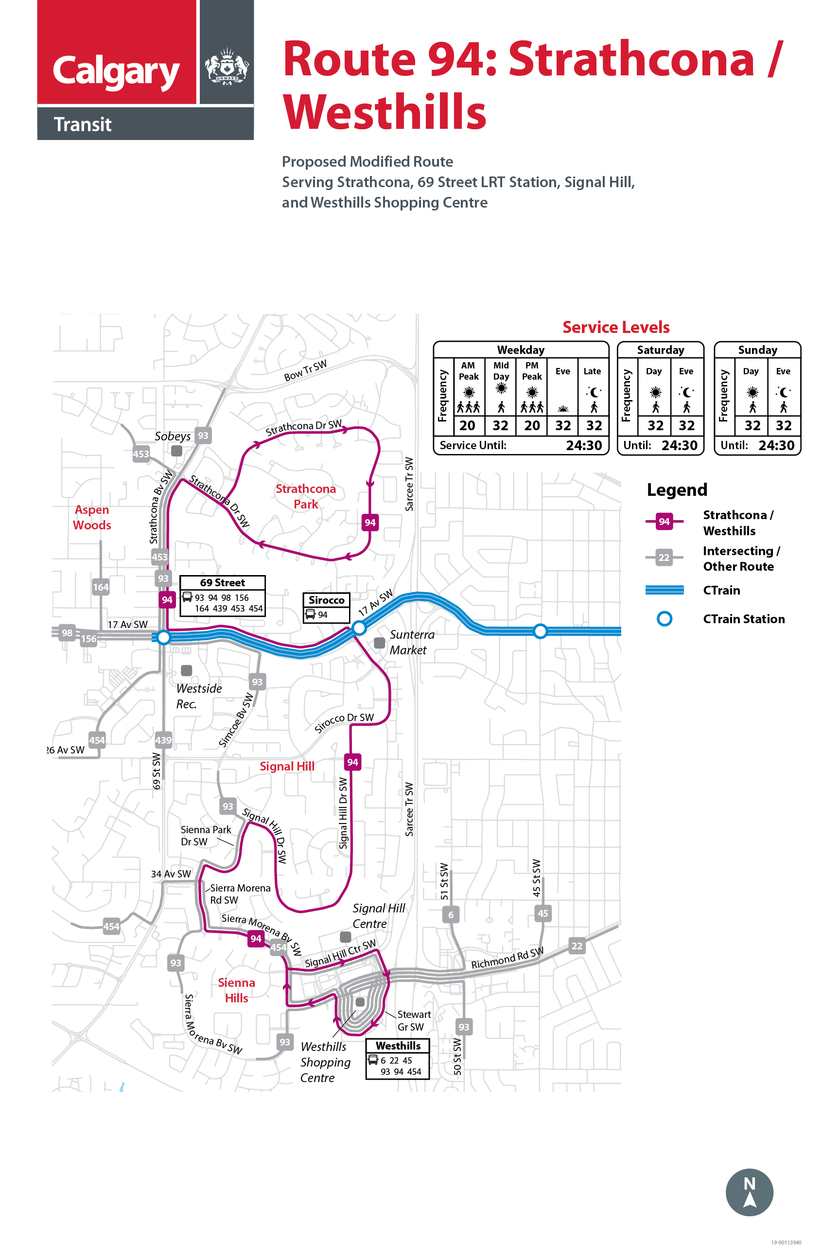
(Click to enlarge)
95
Proposed Route 95: Palliser
Proposed new route. Serving Palliser, Oakridge, Oakridge Co-op, Southland Drive SW, Southland Leisure Centre, and Southland LRT Station.
Route 95 Routing:
- Start at Southland Station Terminal
- North on Sacramento Drive SW
- West on Southland Drive SW
- North on Palliser Drive SW
- West on Oakwood Drive SW
- South on Oakfield Drive SW
- East on Southland Drive SW
- South on Sacramento Drive SW
- End at Southland Station Terminal
Route 95 Service Levels: Proposed to operate every 32 minutes in all service periods. Service provided to 9pm on Weekdays, 6pm on Saturdays, and no service on Sundays.

(Click to enlarge)
99
Proposed Route 99: Oakridge - Acadia
Proposed new route. Serving Palliser, Oakridge, Oakridge Co-op, Southland Drive SW, Southland Leisure Centre, Southland LRT Station, Southcentre Mall, Willow Park, Maple Ridge, Acadia, Lord Beaverbrook High School, Acadia Recreation Centre, and Heritage LRT Station.
Route 99 Routing:
From Southland Station to Oakridge:
- Start at Southland Station Terminal
- North on Sacramento Drive SW
- West on Southland Drive SW
- North on Oakfield Drive SW
- West on Oakwood Drive SW
- East on Palliser Drive SW
- East on Southland Drive SW
- South on Sacramento Drive SW
- End at Southland Station Terminal
From Southland Station to Southcentre, Acadia, and Heritage Station:
- Start at Southland Station Terminal
- North on Sacramento Drive SW
- East on Southland Drive SW
- South on Bonaventure Drive SE
- North on Fairmount Drive SE
- East on Willingdon Boulevard SE
- North on Acadia Drive SE
- West on 90 Avenue SE
- North on Bonaventure Drive SE
- West on Heritage Drive SE
- South on Haddon Road SW
- End at Heritage Station Terminal
From Heritage Station to Acadia, Southcentre, and Southland Station:
- Start at Heritage Station Terminal
- East on Heritage Drive SW
- South on Bonaventure Drive SE
- East on 90 Avenue SE
- East on Acadia Drive SE
- West on Willingdon Boulevard SE
- South on Fairmount Drive SE
- West on Bonaventure Drive SE
- West on Southland Drive SE
- South on Sacramento Drive SW
- End at Southland Station Terminal
Route 99 Service Levels: Proposed to operate every 18 minutes during weekday peak periods, and every 30 minutes at all other times of day. Service provided until midnight on Weekdays, until 11:30 PM on Saturdays, and until 10:15 PM on Sundays.

(Click to enlarge)
101
Proposed Route 101 – Inglewood
Proposed new route. Serving Inglewood, Alice Bisset Place, 9 Avenue SE, East Village, The Core Shopping Centre, The Bay, and Downtown.
Proposed Route 101 routing:
Westbound:
- Start at cul-de-sac at east end of 28 Avenue SE in Inglewood
- North on 17 Street SE, continuing North on 20 Street SE
- West on 9 Avenue SE
- North on 6 Street SE
- West on 6 Avenue SE, continuing west on 6 Avenue SW
- South on 5 Street SW
- East on 9 Avenue SW
- North on 1 Street SW, stopping by The Bay
- Start on 1 Street SW by The Bay
- North on 1 Street SW
- East on 5 Avenue SW, continuing east on 5 Avenue SE
- South on 3 Street SE
- East on 6 Avenue SE
- South on 6 Street SE
- East on 9 Avenue SE
- South on 17 Street SE
- End at cul-de-sac at east end of 28 Avenue SE in Inglewood
Eastbound:
Route 101 service levels. Proposed to operate every 22 minutes during weekday peak periods, and every 42 minutes during all other service periods. Service is provided until approximately 9pm on weekdays, and to 6:30pm on weekends.

(Click to enlarge)
106
Proposed Route 106 – Southland / Deerfoot Meadows
Proposed new route. Serving Southland LRT Station, Southland Drive SE and Deerfoot Meadows Shopping Centre.
Route 106 Routing:
- Start at Southland LRT Station
- East on Southland Drive SE
- North on Blackfoot Trail SE
- East on Heritage Drive SE
- South on Heritage Meadows Road SE
- West on Heritage Meadows Way SE
- North on 11 Street SE
- West on Heritage Drive SE
- South on Blackfoot Trail SE
- West on Southland Drive SE
- End at Southland LRT Station
Route 106 Service Levels. Proposed to operate every 22 minutes during peak periods, and every 42 minutes at all other times. Service is provided until 18:00 on weekdays, Saturdays and Sundays.

(Click to enlarge)
125
Proposed Route 125 – Cedarbrae and Route 126 - Braeside
Proposed new routes. Serving Cedarbrae, Braeside, Oakridge Co-op, Southland Drive SW, Southland Leisure Centre, and Southland LRT Station. The routes operate as clockwise and counterclockwise loops through the communities of Cedarbrae and Braeside.
Route 125 Routing:
- Start at Southland LRT Station
- West on Southland Drive SW
- South on Oakfield Drive SW
- West on Cedarille Drive SW
- East on Oakfield Drive SW, continuing east on Braeside Drive SW
- East on Southland Drive SW
- Ends at Southland LRT Station
Route 125 service levels. Proposed to operate every 16 to 30 minutes during peak periods, and every 30 minutes at all other times. Service is provided until midnight on weekdays, and 11:30pm on Saturday and Sunday.
Route 126 Routing:
- Start at Southland LRT Station
- West on Southland Drive SW
- South on Braeside Drive, and continuing west on Oakfield Drive SW
- South on Cedarille Drive SW
- North on Oakfield Drive SW
- East on Southland Drive SW
- Ends at Southland LRT Station
Route 126 service levels. Proposed to operate every 16 to 30 minutes during peak periods, and every 30 minutes at all other times. Service is provided until 9pm on weekdays, 6pm on Saturdays, and no service on Sundays.

(Click to enlarge)
126
Proposed Route 125 – Cedarbrae and Route 126 - Braeside
Proposed new routes. Serving Cedarbrae, Braeside, Oakridge Co-op, Southland Drive SW, Southland Leisure Centre, and Southland LRT Station. The routes operate as clockwise and counterclockwise loops through the communities of Cedarbrae and Braeside.
Route 125 Routing:
- Start at Southland LRT Station
- West on Southland Drive SW
- South on Oakfield Drive SW
- West on Cedarille Drive SW
- East on Oakfield Drive SW, continuing east on Braeside Drive SW
- East on Southland Drive SW
- Ends at Southland LRT Station
Route 125 service levels. Proposed to operate every 16 to 30 minutes during peak periods, and every 30 minutes at all other times. Service is provided until midnight on weekdays, and 11:30pm on Saturday and Sunday.
Route 126 Routing:
- Start at Southland LRT Station
- West on Southland Drive SW
- South on Braeside Drive, and continuing west on Oakfield Drive SW
- South on Cedarille Drive SW
- North on Oakfield Drive SW
- East on Southland Drive SW
- Ends at Southland LRT Station
Route 126 service levels. Proposed to operate every 16 to 30 minutes during peak periods, and every 30 minutes at all other times. Service is provided until 9pm on weekdays, 6pm on Saturdays, and no service on Sundays.
(Click to enlarge)
132
Proposed Route 132 – Killarney 29 Street SW
Proposed new route. Serving Westbrook LRT Station, Westbrook Mall, Killarney Recreation Centre, 29 Street SW, Sarcee Road, and Glamorgan.
Proposed Route 132 routing:
- Start at Westbrook LRT Station
- South on 33 Street SW
- East on 17 Avenue SW
- South on 29 Street SW, continuing south on Sarcee Road SW
- West on Richardson Way SW, continuing west on 46 Avenue SW
- South on 43 Street SW
- West on Gordon Drive SW
- South on 43 Street SW
- West on Galbraith Drive SW, continuing north on Galbraith Drive SW
- West on 49 Avenue SW
- North on 45 Street SW
- East on 46 Avenue SW
- East on Richardson Way SW
- North on Sarcee Road SW, continuing north on 29 Street SW
- West on 17 Avenue SW
- North on 33 Street SW
- Ends at Westbrook LRT Station
Route 132 service levels. Proposed to operate every 17 minutes during peak periods, and every 32 minutes at all other times. Service is provided until 12:30am on weekdays, midnight on Saturday and 11pm on Sunday.

(Click to enlarge)
141
Proposed Route 141 – 14 Street NW
Proposed new route. Serving Lions Park LRT Station, North Hill Mall, 14 Street NW, and North Haven.
Route 51 and 141 are connected at Lions Park LRT Station. Route 141 buses arriving at this station will turn into Route 51 to continue south on 14 Street NW. Route 51 buses arriving at this station will turn into Route 141 to continue north on 14 Street NW.
Proposed Route 141 routing:
- Start at Lions Park LRT station
- East on 14 Avenue NW
- North on 14 Street NW
- East on North Haven Drive NW
- North on North Haven Drive NW
- West on 48 Avenue NW
- South on Niven Road NW
- West on Norquay Drive NW
- South on Norquay Drive NW
- West on North Haven Drive NW
- South on 14 Street NW
- West on 16 Avenue NW
- South on 19 Street NW
- East on 14 Avenue NW
- End at Lions Park LRT station
Route 141 service levels. Will operate every 30 minutes during weekday peak periods, and every 52 minutes during all other service periods. Service is provided until approximately 6:30pm on weekdays, and to 6:30pm on weekends.
(Click to enlarge)
149
Proposed Route 149 – Point Trotter
Proposed modified route. Serving Heritage LRT Station, Heritage Drive SE, Deerfoot Meadows, South Hill Terminal, South Foothills Industrial, Point Trotter Industrial.
Route 149 routing:
Eastbound:
- Start at Heritage LRT Station
- East on Heritage Drive SE
- East on Glenmore Trail SE
- South on Ogden Road SE, turn around at roundabout at 86 Avenue at South Hill
- North on Ogden Road SE
- East on Glenmore Trail SE
- South on Barlow Trail SE
- East on 90 Avenue SE
- South on 52 Street SE
- East on 94 Avenue SE
- Turnaround in Point Trotter Industrial Park via 106 Avenue
- Starting in Point Trotter Industrial Park
- West on 94 Avenue SE
- North on 52 Street SE
- East on 86 Avenue SE
- South on 60 Street SE
- West on 90 Avenue SE
- North on Barlow Trail SE
- West on Glenmore Trail SE
- South on Ogden Road SE, turn around at roundabout at 86 Avenue at South Hill
- North on Ogden Road SE
- West on Glenmore Trail SE
- West on Heritage Drive SE
- End at Heritage LRT Station
Westbound:
Route 149 service levels. Proposed to operate every 25 minutes during weekday peak periods, and every 35 minutes during all other service periods. Service to be provide until 7pm on weekdays, until 6pm on Saturdays, and no service on Sundays.

(Click to enlarge)
302
Proposed Route 302 – BRT Southeast
Proposed modification to route in East Village. Route 302 serves Downtown, Inglewood, Highfield Industrial, Ogden, Quarry Park, Douglas Glen Terminal, New Brighton, McKenzie Towne, Mahogany, Auburn Bay, Seton, and South Health Campus.
Route 302 routing:
Northbound
- Routing between South Health Campus and Inglewood has no change
- Arriving from Inglewood via 9 Avenue SE, continuing west on 9 Avenue SE
- North on 3 Street SE
- West on 6 Avenue SE
- South on 5 Street SW, ending at 5 Street at 7 Avenue SW
Southbound
- Start from 5 Street at 7 Avenue SW
- South on 5 Street SW
- East on 9 Avenue SE, continuing into Inglewood
- Rest of route to South Health Campus has no change.
Route 302 service levels. No change proposed to frequency or service span.

(Click to enlarge)
MAX
MAX Southwest
New MAX line. Serving Woodbine, Southland Leisure Centre, Heritage Park, Rockyview Hospital, Mount Royal University, Crowchild Trail, Marda Loop, and Downtown.
MAX Southwest routing:
Northbound:
- Start on 24 Street SW in Woodbine at Woodpark Boulevard SW
- North on 24 Street SW
- East on Southland Drive
- North on Transitway beside 14 Street SW
- North on 14 Street SW
- West on Glenmore Trail SW
- North on Crowchild Trail SW
- West on 50 Avenue SW
- North on Richard Road SW
- North on Crowchild Trail SW
- East on Bow Trail SW, continuing east on 9 Avenue SW
- North on 6 Street SW
- East on 5 Avenue SW – ends near 1 Street SW
Southbound:
- Start on 5 Avenue at 1 Street SW
- South on 1 Street SW
- West on 6 Avenue SW, continuing west on Bow Trail SW
- South on Crowchild Trail SW
- South on Richard Road SW
- East on 50 Avenue SW
- South on Crowchild Trail SW
- East on Glenmore Trail SW
- South on 14 Street SW
- South on Transitway beside 14 Street SW
- West on Southland Drive SW
- South on 24 Street SW
- End at Woodbine on 24 Street SW
MAX Southwest service levels. Will operate every 10 minutes during weekday peak periods, every 22 minutes during weekday mid-day periods, and every 25 to 30 minutes during all other service periods. Service is provided until approximately 11:30pm on weekdays, and to 10:30pm on weekends.

(Click to enlarge)
PROVIDE YOUR INPUT
Please provide your input on a NEW proposed bus route. You can submit one entry per route but make sure to click the Submit button before starting a new submission.ROUTES
If you currently take Route… |
You may be interested in proposed Route… |
|
6 - Killarney 26 Ave |
|
|
7 - Marda Loop |
|
|
13 - Mount Royal |
|
|
16 - Palliser |
|
|
18 - Lakeview |
|
|
20 - Heritage / Northmount |
|
|
39 - Acadia |
|
|
47 - Lakeview |
|
|
56 - Woodbine |
|
|
79 - Acadia / Oakridge |
|
|
80 - Oakridge / Acadia |
|
|
81 - Macleod Trail |
|
|
84 - Palliser |
|
|
93 - Coach Hill / Westbrook |
|
|
94 - Strathcona / Westbrook |
|
|
112 - Sarcee Road |
MAX Southwest, 22, 93, 132 |
|
149 - Point Trotter |
|
|
302 - BRT Southeast |
|
|
411 - East Calgary |
|
|
414 - 14 Street Crosstown |


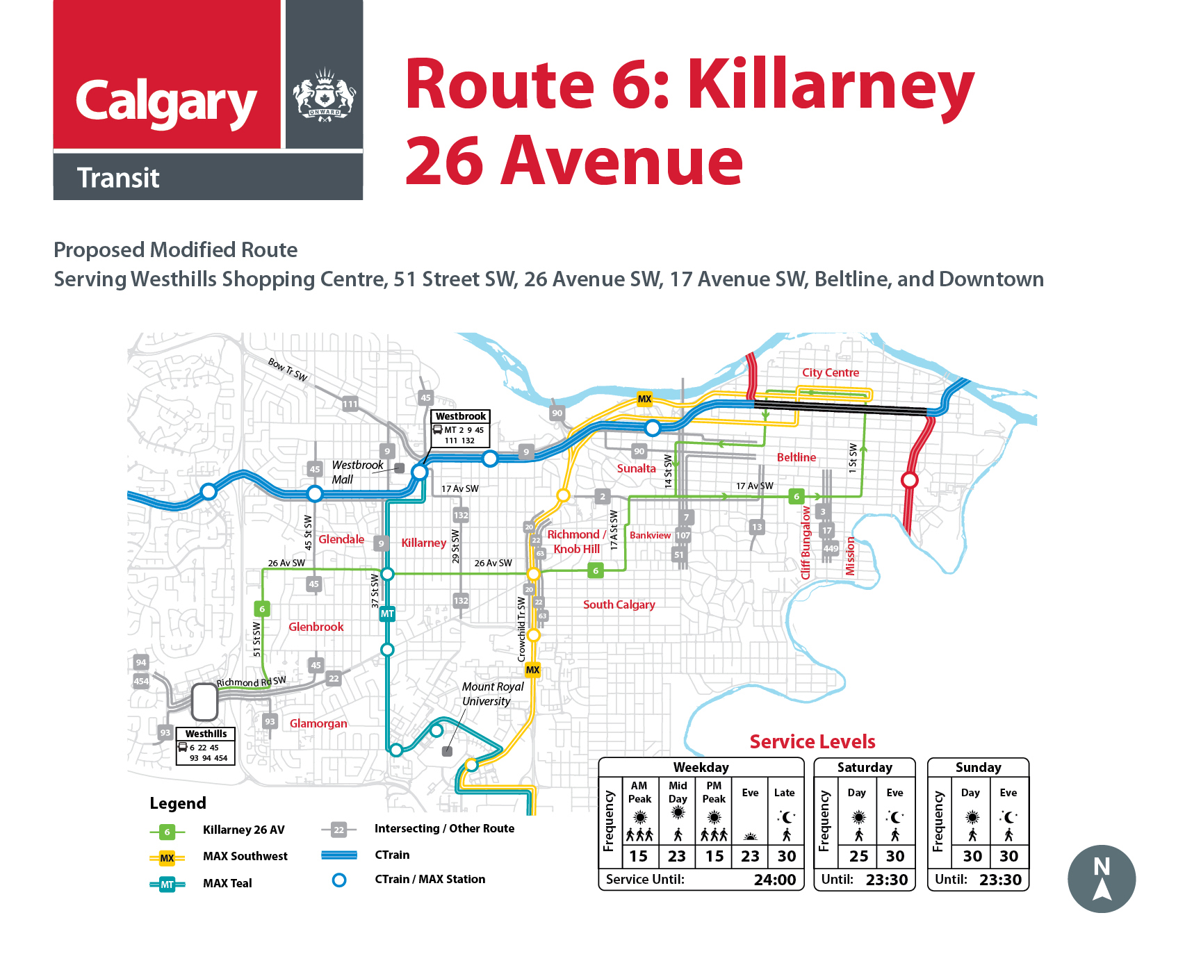
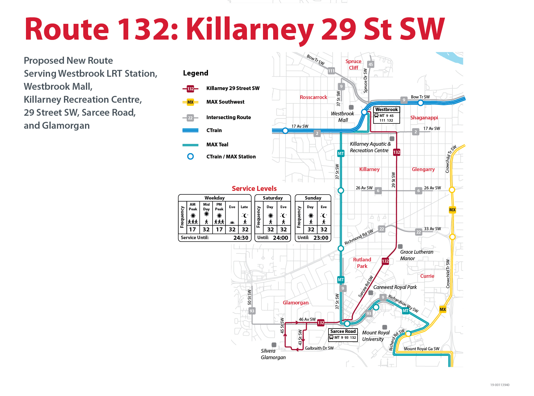
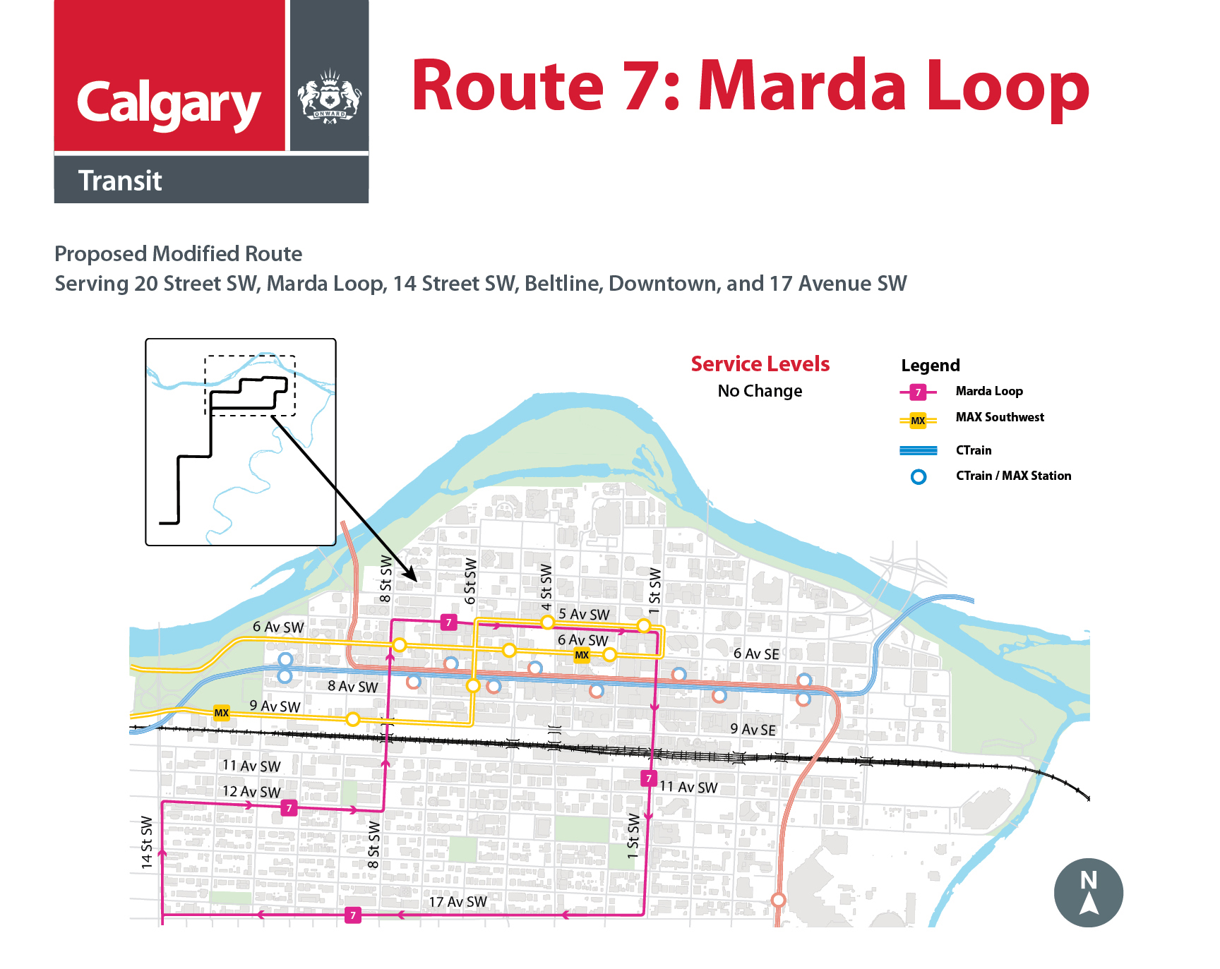
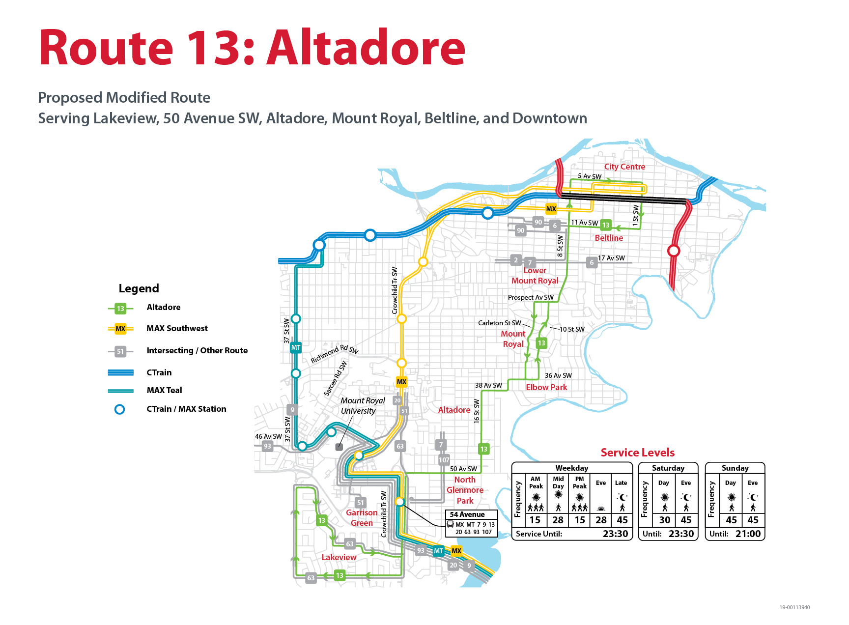
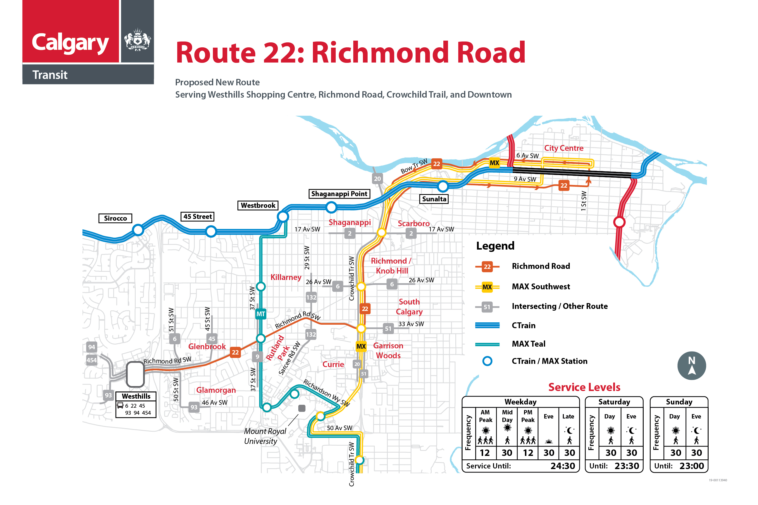
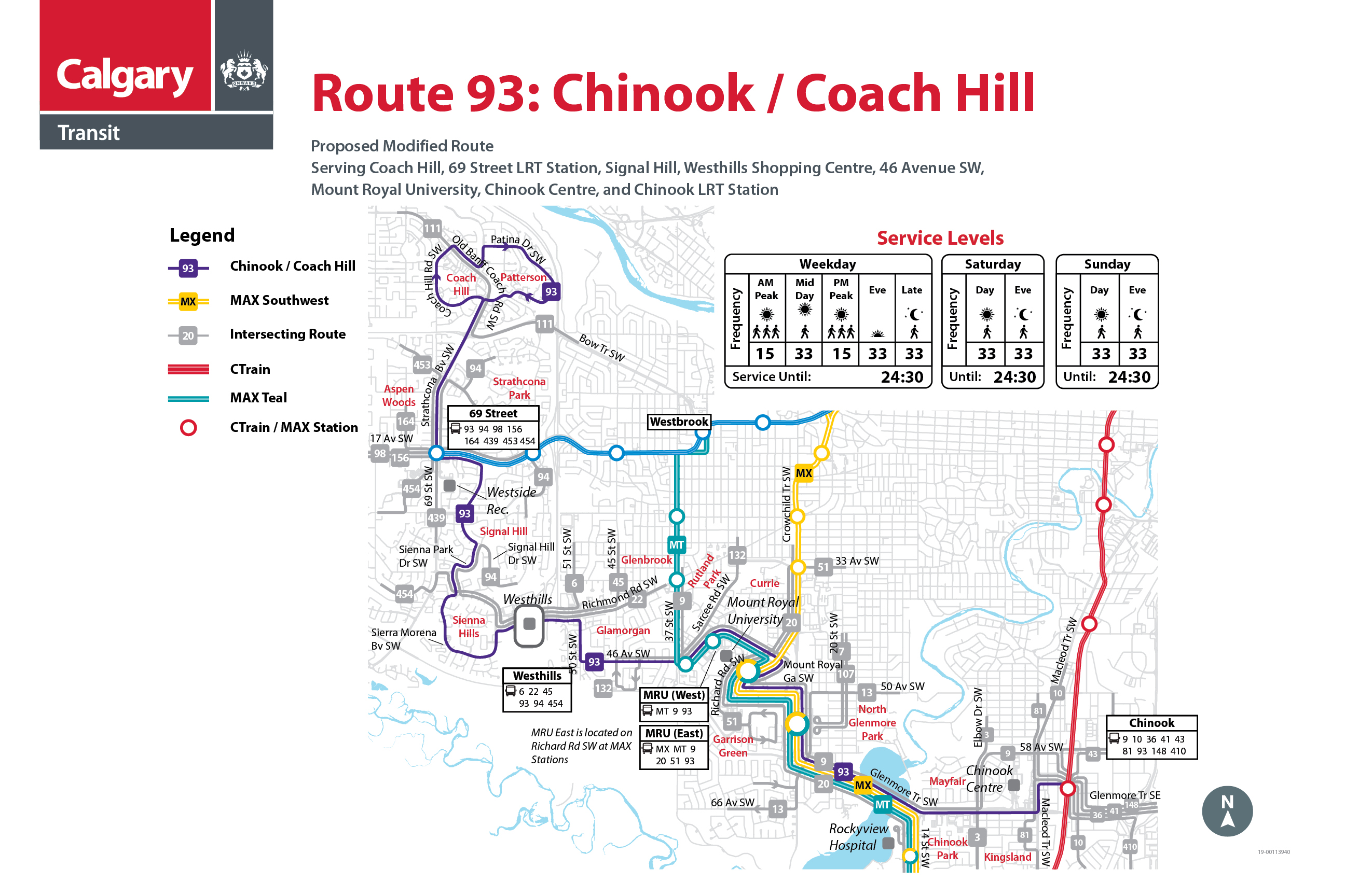
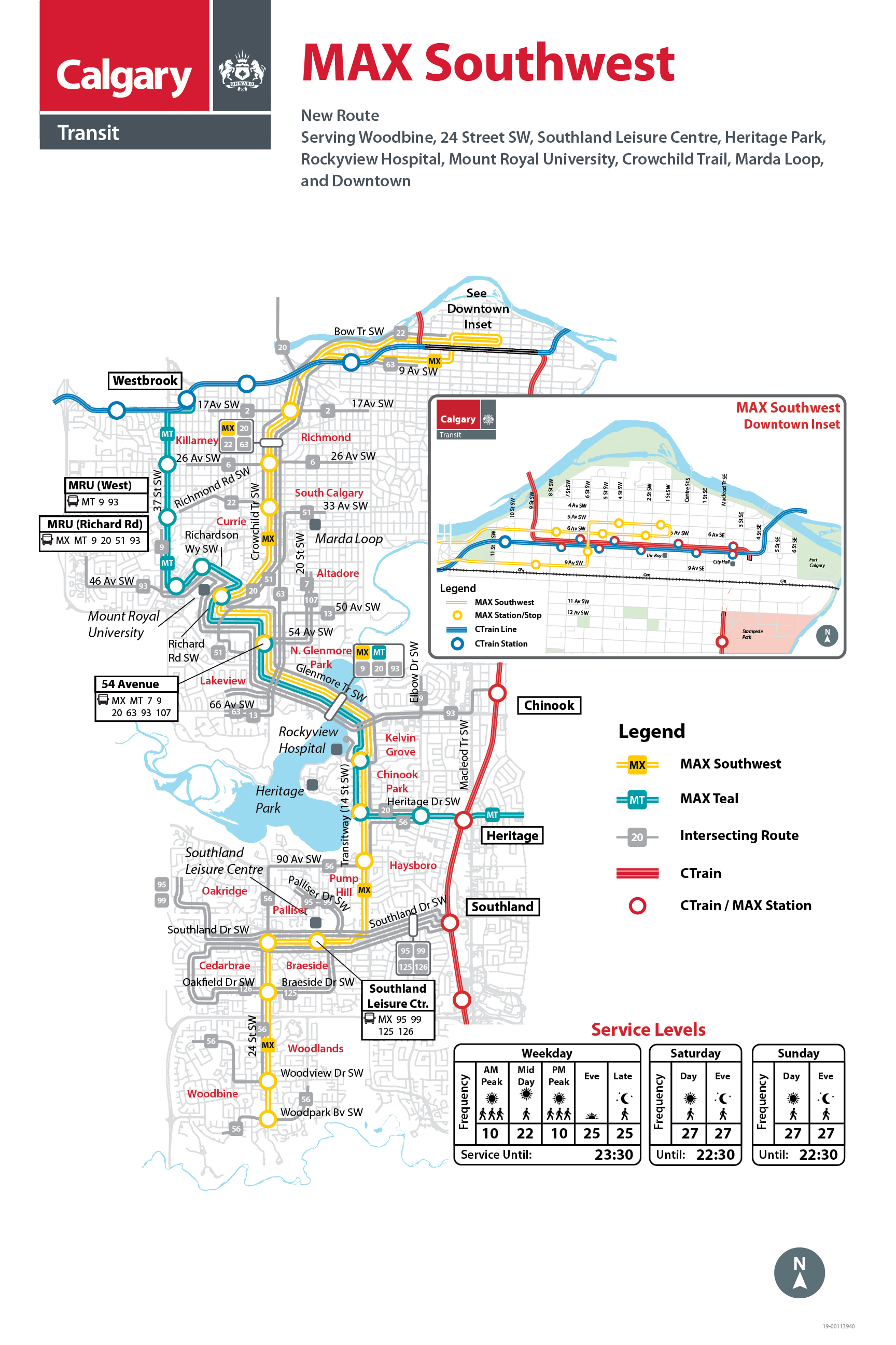
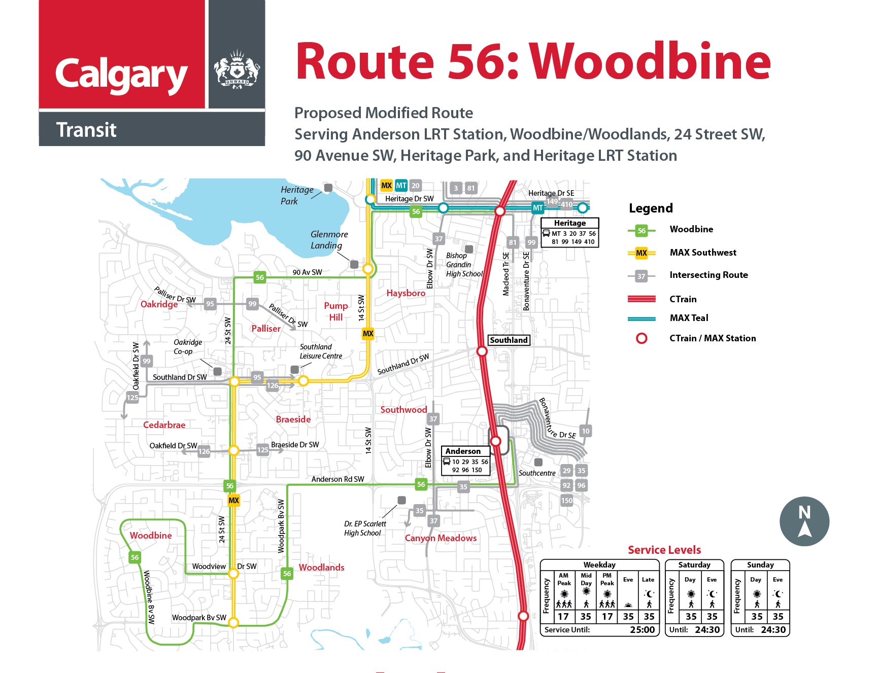
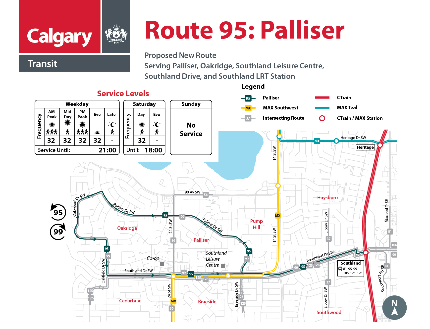
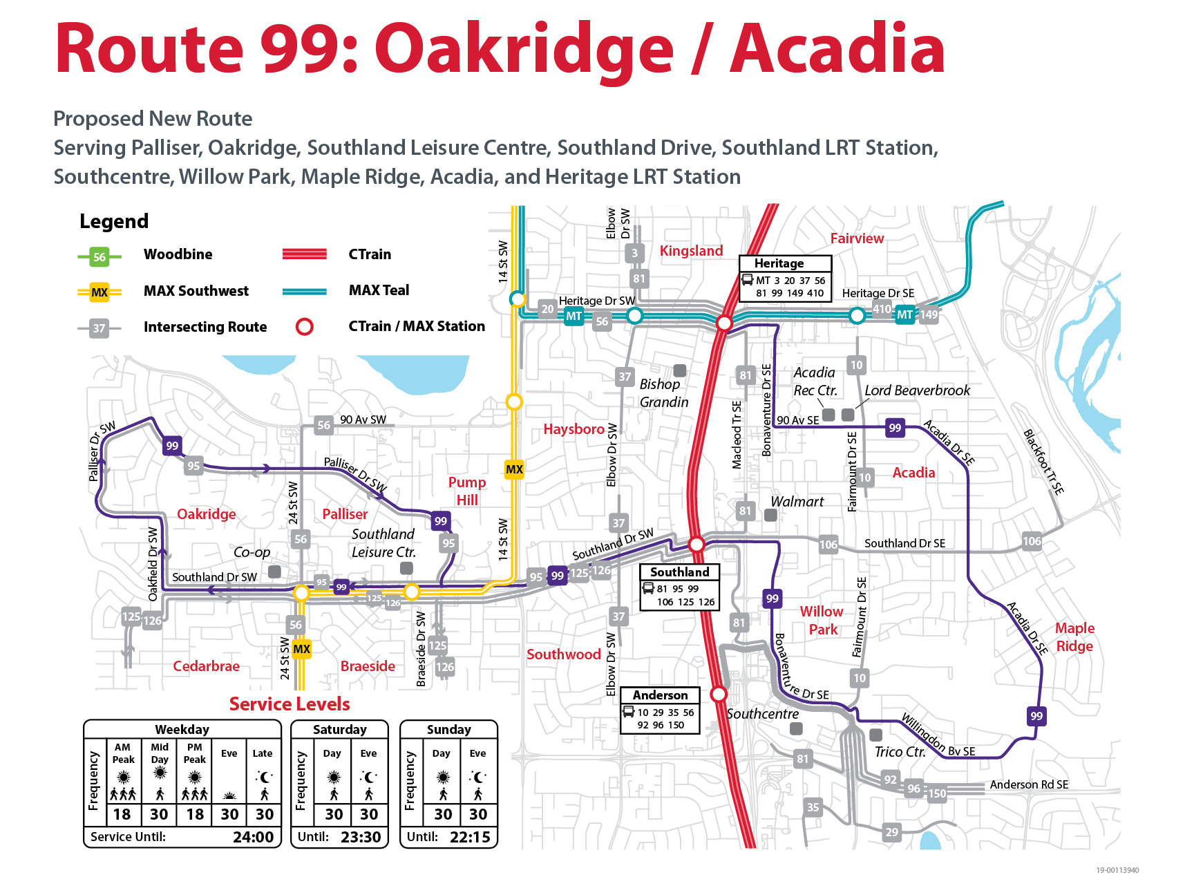
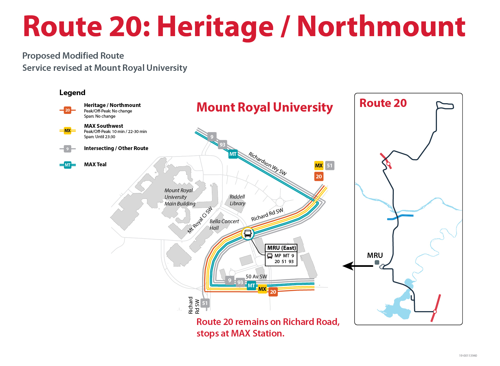
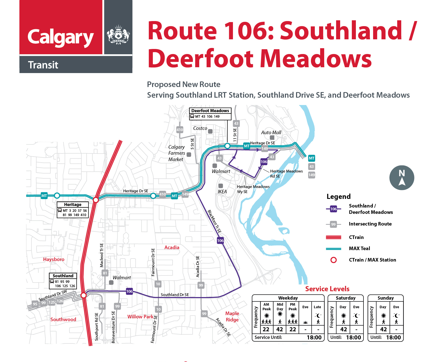
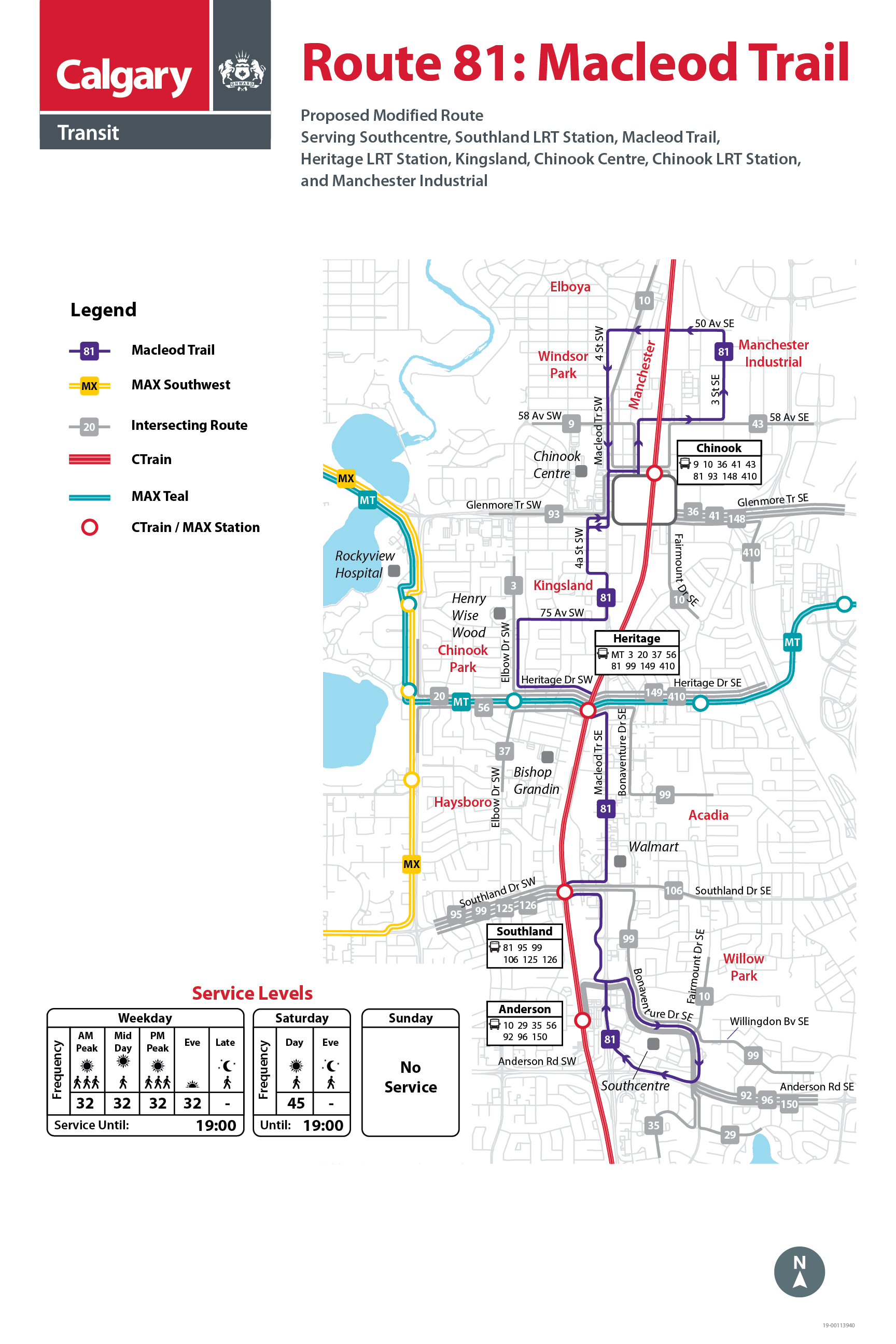
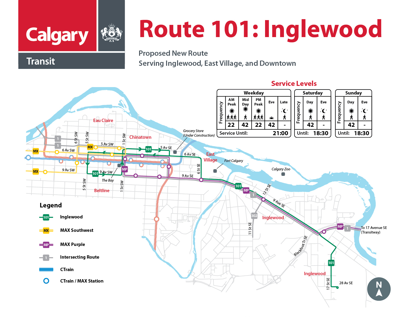