Riley Communities Local Area Plan
The Riley Communities Local Area Plan project has now concluded. For the most up-to-date information, please click the link below.
Riley Communities Local Area Plan Approved by Council
On March 4, 2025, Council approved Three Readings to the Riley Communities Local Area Plan (Bylaw 25P2025), with amendments, in a 10-2 vote. View the Council-approved Plan here.
Summary of Council-directed Amendments:
- Amend Urban Form Category and Building Scale Maps (Map 3 and 4) of the Riley Communities Local Area Plan for two blocks located on the south side of 1 Avenue NW between 7 Street NW and 9 Street NW. This Council-directed amendment requires readvertising and will be brought forward to Council on April 8, 2025 as an amendment to the Plan that was approved on March 4, 2025.
Summary of Council-approved Amendments:
- Update the Riley Communities Local Area Plan to remove all references to the “Calgary Metropolitan Region Board” (CMRB) and any such appendices that were included that would enable a Regional Evaluation Framework circulation to be undertaken.
Adjust Urban Form Category & Building Scale for two blocks located on the south side of 1 Avenue NW between 7 Street NW and 9 Street NW as per the following:
That with respect to Revised Report IP2025-0009, the following amendment be adopted, as amended:
That Council insert a new Recommendation 1 as follows, and renumber the subsequent recommendations accordingly:
- Direct Administration to prepare the following amendments for the portion of the block that is located on the south side of 1 Avenue NW between 7 Street NW and 9 Street NW and to bring a new proposed bylaw directly to the 2025 April 08 Public Hearing of Council for three readings:
- Amend Map 3: Urban Form by changing “Neighbourhood Local” to “Neighbourhood Connector”; and
- Amend Map 4: Building Scale by changing “Limited (up to 3 storeys)” to “Low (up to 6 storeys)”.
OUTCOME Motion Carried
To update the Staff Report Recommendation with the Motion 1 amendments:
That with respect to Revised Report IP2025-0009, the following be adopted, as amended:
That Council:
- Direct Administration to prepare the following amendments for the portion of the block that is located on the south side of 1 Avenue NW between 7 Street NW and 9 Street NW and to bring a new proposed bylaw directly to the 2025 April 08 Public Hearing of Council for three readings:
- Amend Map 3: Urban Form by changing “Neighbourhood Local” to “Neighbourhood Connector”; and
- Amend Map 4: Building Scale by changing “Limited (up to 3 storeys)” to “Low (up to 6 storeys)”;
- Give three readings to Proposed Bylaw 25P2025 to adopt the Riley Communities Local Area Plan and repeal Bylaw 19P87 Hillhurst/Sunnyside Area Redevelopment Plan and Bylaw 15P89 Hounsfield Heights/Briar Hill Area Redevelopment Plan (Attachment 2);
- RESCIND, by resolution, the North Bow Design Brief;
- Give three readings to Proposed Bylaw 26P2025 for amendments to the 1P2007 Land Use Bylaw to implement Heritage Guideline Areas (Attachment 6); and
- Direct that Confidential Attachment 14 remain confidential pursuant to Section 17 (Disclosure harmful to personal privacy) of the Freedom of Information and Protection of Privacy Act, not to be released.
OUTCOME Motion Carried
Update the Riley Communities Local Area Plan to remove all References of “Calgary Metropolitan Region Board (CMRB)”
That Proposed Bylaw 25P2025 be amended as follows:
- In Contents, delete the text “Appendix B: Regional Corridors and Context Map” under the heading “Appendices” and renumber the subsequent appendices and references to the subsequent appendices accordingly throughout Attachment 2.
- In Contents, delete the text references to “Map B1: Regional Transmission Corridors and Context, Map B2: Regional Transportation Corridors and Context and Map B3: Growth Plan Placetype Alignment” under the heading “Maps” and renumber the subsequent maps accordingly.
- In Section 4.1 Policy Framework, delete the text “, and the Regional Growth Plan” at the end of the third sentence.
- In Section 4.2 Local Area Plan Interpretation, delete policy (g) and renumber subsequent policies accordingly.
- Delete the existing Appendix B entitled “Regional Corridors and Context Map” in its entirety including the existing Map B1 entitled “Regional Transmission Corridors and Context”, existing Map B2 entitled “Regional Transportation Corridors and Context”, and existing Map B3 entitled “Growth Plan Placetype Alignment” and renumber the subsequent maps and references to the subsequent maps accordingly throughout Attachment 2.
OUTCOME Motion Carried
Proposed Riley Communities Local Area Plan
The Riley Communities Local Area Plan (the Plan) is the result of over two and half years of engagement with participants including residents, business owners, community association youth, seniors, and development industry representatives, and a dedicated and diverse working group. Feedback provided by participants throughout the process helped shape and refine the Plan that was brought forward to Council. A recording of Council, presentation and attachments can be viewed online here.
The Plan sets out the vision and policies to guide growth, change and investment over the next 30 years in the communities of Sunnyside, Hillhurst, West Hillhurst and Hounsfield Heights - Briar Hill. In addition to policies directing how land can be used and redeveloped in the area, the Plan identifies community improvements and investments to support communities as they experience growth and change.
With the approval of the Riley Communities Local Area Plan, there is now direction on future development, investment and community improvements that residents, landowners, builders/developers, planners and Councillors can commonly refer to when new development and investment ideas are proposed.
The Plan aims to support the area as it evolves by:
- Increasing housing choice and affordability;
- Improving Pedestrian and cycling pathways;
- Enhancing local parks and open spaces.
- Incentivizing heritage retention in the Riley Communities; and,
- Fostering vibrant transit station areas.
Thank you to everyone who dedicated their time and provided input throughout the creation of the Riley Communities Local Area Plan. Your contributions and the contributions of others who are passionate about this area helped shape the Plan that has been approved. Your interest, time and dedication are invaluable and truly appreciated.
POST-COMMITTEE UPDATE
On January 30, 2025, the Proposed Riley Communities Local Area Plan was presented to the Infrastructure and Planning Committee (IPC). The Plan was recommended for approval with amendments (expand accordion below for details).
The updated version of the Riley's Communities Local Area Plan will be brought forward to a Public Hearing of Council for review and decision on March 4, 2025.
Hey Riley Communities! The UPDATED proposed Plan is ready.
Plan Vision & Key Moves
We heard a wide range of perspectives from communities on housing choice and learned about individuals’ different preferences and needs when finding a home, such as location, price, size, style, proximity to amenities or outdoor space.
The Plan considers these differing perspectives and takes a balanced approach that enables a range of small-scale homes in the Riley Communities while supporting higher growth in specific areas such as around transit stations and Main Streets. Increasing housing types and choices will help as the population increases and new families move in while also helping residents to stay in the area as they age or as their needs change.

The Riley Communities include two transit station areas along the Red Line LRT. Sunnyside and Lions Park LRT stations serve as important connections to link these communities to each other, and the rest of the city. The Plan envisions these transit station areas as focal points that will continue to evolve into vibrant, mixed-use areas that provide housing and amenities for current and future residents.
The Plan also recognizes that the North Hill Mall site, north of the Lions Park LRT station, has the potential to provide more housing options while expanding upon its current commercial uses. By improving the public space around the station area and encouraging high-density, mixed[1]use development, while retaining the existing important amenities on the site, the full potential of the station area can start to be realized.
These transit station areas are intended to provide a concentration of private and public amenities that are supported by higher-density development, higher levels of pedestrian activity and connections to different mobility options. The Plan provides specific direction for improvements within these areas including the creation of public space plans that include elements such improved pedestrian infrastructure, landscaping, lighting, sitting and gathering areas, and wayfinding.
![]()
We’ve have heard from individuals that they deeply value the parks, recreation facilities, natural areas and public spaces throughout the Riley Communities, including the McHugh Bluff, Grasshopper Hill and the Bow River regional pathway system. The Plan also recognizes that the Riley Communities are unique as they are bordered by the Bow River to the south and have abundant opportunities to interact with this natural feature. These natural features and open spaces not only provide opportunities for recreational activities and support people’s active lifestyles, but they also contribute to the overall ecological health of the area by providing cooling, shading, and stormwater retention.
Improving access to these open spaces and parks is a key component of the Plan, which encourages accessible, inclusive, and year-round programming for these spaces. The Plan also provides direction to protect, maintain, and support the urban tree canopy throughout the Riley Communities while supporting the preservation and restoration of riparian areas using natural infrastructure to enhance resilience to river flooding. Ensuring that the parks and open spaces in the Riley Communities have improved facilities and accessibility will result in more people being able to enjoy these valuable amenities.

Being able to walk and ride bikes through the neighborhoods would be wonderful. –Participant We’ve heard from residents about the unique histories, places and people that define the Riley Communities. The Plan areas heritage keeps the stories of past generations alive for present and future generations. It is a valued part of the Riley Communities identity and is an important part of Calgary’s history. Heritage takes various forms in the Plan area and contributes to the character of the community while creating a sense of identity and place. The Plan includes policy to support the retention and maintenance of heritage buildings and to encourage design solutions such as building articulation and material variation to provide a sensitive interface between new development and heritage resources in the Riley Communities.
To recognize and celebrate the unique history and resulting built form that’s seen in parts of the Riley Communities, Heritage Guideline Areas have also been identified in heritage-rich parts of the Plan area requiring new development to be contextually sensitive to surrounding heritage assets. These heritage assets are privately owned structures, typically constructed prior to 1945, that significantly retain their original form, scale, massing, window/door pattern and architectural details or materials.

We’ve heard from individuals that they value active modes as key ways to move around the Riley Communities and to surrounding destinations. Prioritizing an integrated and complete multi[1]modal transportation network, including pathways and bikeways, is a goal of this Plan. Existing cycling routes along streets such as 5/6 Avenue NW, 10 Street NW, 9A Street NW, 21 Street NW, 17A Street NW, 19 Street NW and 2 Avenue NW link the Riley Communities to one another as well as to adjacent communities and other destinations including downtown, the Bow River, the Southern Alberta Institute of Technology (SAIT) and Alberta University of the Arts (AUArts) campuses, and the University of Calgary.
The Plan focuses on enhancing these routes and building upon existing infrastructure such as the Red Line LRT system, regional pathway system and pedestrian network to provide safer, more direct and convenient mobility options for residents in the Riley Communities.
In addition, a mobility study is also being undertaken to provide a long-term roadmap for The City to guide transportation improvement projects and investments to address issues and opportunities that may emerge through ongoing growth and change in the Plan Area.

Building Scale Map Changes


Urban Form Map Changes


The Urban Form & Building Scale Maps help visualize where and how growth and change could happen in the plan area over the next 30 years and beyond.
The Urban Form and Building Scale Maps are intended to be interpreted together.
- The Urban Form Map shows types of buildings and what they should be used for. These can include primarily commercial/business areas, primarily residential areas and parks and open space.
- The Building Scale Map outlines The Building Scale Map shows the maximum height and size buildings can be in a specific area. Scale categories contain policies that outline building heights and other design considerations such as stepbacks (where higher floors are setback from lower floors).
Additional details on the categories within these maps can be found in section 2.2 and 2.3 of the Riley Communities Local Area Plan or within the Visual Legend.
It's important to remember that change is very gradual and the Local Area Plan itself does not rezone land. It is property/landowners who determine if and when to propose to rezone their land.
A local area plan sets the vision for the evolution of the area—providing direction on future development and investment that residents, landowners, builders / developers, City Planners and Councillors can commonly refer to as new development and investment ideas are proposed.
Right click and select "open image in new tab" to see larger version of each map.
Alternatively, PDF versions can be found in the About the maps tab above.
 |
|
|
|
|
|
|
|
|
|
|
|
|
|
|
|
|
|
|
|


| Limited (up to 3 storeys)
|
| Low-Modified (up to 4 storeys)
|
| Low (up to 6 storeys)
|
| Mid (up to 12 storeys)
|
| High (up to 26 storeys)
|
| Highest (over 26 storeys)
|
| No Scale Modifier |
| Parks, Civic and Recreation |


Key Changes
For additional information about how the Urban Form and Building Scale maps have evolved over time based on input, including public feedback, take a look at the Summary of Map Changes for the plan that went to IPC in October 2024.
Engagement Overview
Together, over a two-year period with thousands of participants, a local area plan for the Riley Communities was created.
From January 2022 – May 2024, conversations about where, why and how revitalization and redevelopment should happen took place with a range of participants. Thousands of individuals were involved in the creation of the Plan from youth to seniors, residents and business owners, community association and development industry representatives and a dedicated and diverse working group that provided in-depth insights and feedback throughout.
A variety of opportunities for involvement were available through the process that aimed to accommodate a range of participation interests and intensities, as well as to remove barriers to participation.
Engagement opportunities and methods included: Riley Communities Working Group sessions, in-person and virtual engagement sessions (with the public, community associations, heritage & development industry representatives), pop-up engagement events, online engagement, mailed engagement packages, My Idea Stations, and community walking tours (with community association representatives).
Through the project, over two million advertisements were displayed to help raise awareness of the project and opportunities to get involved. Methods used to raise awareness included: mailed information, community newsletter articles and ads, large format road signs, social media ads (Facebook, Twitter, Instagram, Nextdoor), digital ads (including video ads on YouTube and audio ads on Spotify), digital and print ads in local restaurants, Communications Toolkits for area Councillors and Community Association representatives to help spread the word.
Over 23 public engagement events, 8 community association sessions, 9 working group sessions, and 3 builder/development industry sessions were held. Online engagement was open for 25 days and over 30,000 engagement packages/booklets were mailed to residents and businesses. Overall, there were over 1,500 unique instances of direct engagement and over 3,000 comments were shared.
Input provided by residents and other participants helped the project team understand perspectives, opinions and concerns throughout the all phases of the project. Input collected in each phase of the project helped influence and inform the concepts and policies that were created and refined throughout the process. Throughout the project, the project team shared what was heard, highlighted the key themes raised, and provided responses for how key themes were addressed and considered.
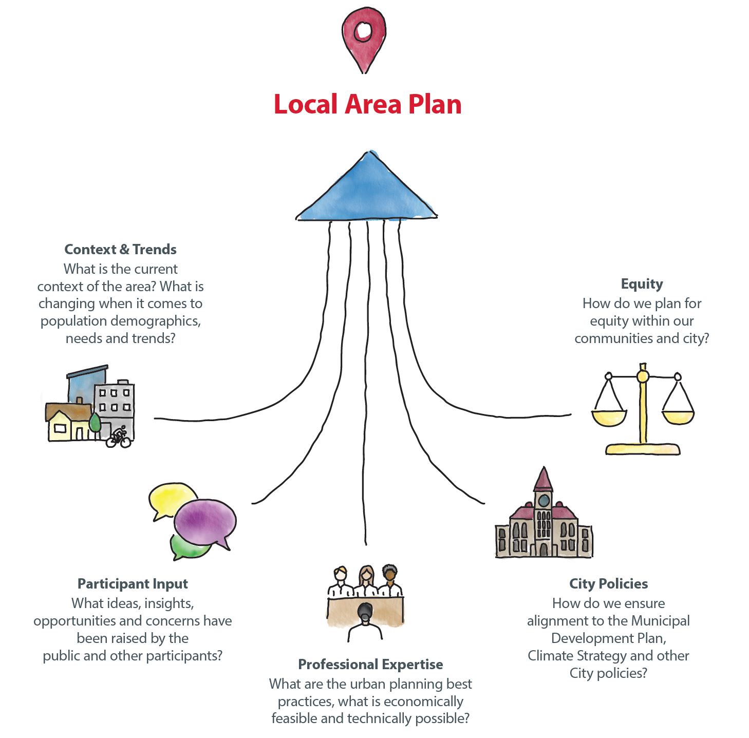
Although it would be a great outcome, the goal of public engagement is not to reach consensus or make everyone happy. Public engagement is about considering the input, ideas and perspectives of those who are interested in or impacted by decisions, before decisions are made. Participant input is an important part of local area planning, but is one of many areas of consideration. Other areas include: City policies, professional expertise, current context and trends, and equity which all factor into the ultimate decision-making process and concept development.
Public input provided in each phase of the engagement process was compiled, reviewed and considered as each chapter of the local area plan was created.


What We Heard & What We Did
FAQs
Frequently Asked Questions
The Riley communities are made up of Hillhurst, West Hillhurst, Sunnyside and Hounsfield Heights – Briar Hill.
A local area plan sets the vision for growth and change in a group of communities over the next 30+ years. A local area plan provides guidance and direction on development and investment that residents, landowners, builders/developers, City Planners and Councillors can commonly refer to when new ideas are proposed for the area.
A local area plan will support your community as it changes by:
- Increasing predictability about how the area could change in the future.
- Responding to changing trends and demographics such as population decline, family composition, aging in place, housing preferences.
- Expanding housing choice to welcome additional people and increase population.
- Supporting local amenities and businesses through increased population.
- Informing decisions about reinvestment such as improvements to public spaces.
- Adding more homes, increasing bikeability, walkability and access to amenities and transit, as well as reducing the need to expand our city’s footprint all play a role in environmental sustainability.
Growth and change happens in a community with or without a local area plan in place. Areas that do not have a local area plan still see site-by-site rezoning and development applications to build developments to meet demand for new housing and businesses.
This site-by-site approach can create uncertainty for local residents, who don’t know where the next application will come and what it will propose. It also creates uncertainty for builders and developers, who don’t know for certain what types of proposals will be acceptable where.
Without a local area plan, conversations about growth and change happen application-by-application, often in a manner disconnected from a wider vision. A local area plan provides a vision for growth and change in an area and helps guide where certain development may be appropriate or not.
While Calgary’s population has been growing approximately 1.8 per cent every year since 1985, the peak population within 86 per cent of Calgary’s established communities has declined.
Population stability within established communities is essential to support local schools, businesses, services and infrastructure. Greater housing choice and diversity supports increased population and stabilization within Calgary’s established communities.

Expanding the types of homes that can be built is a great way to improve housing choice in a community naturally over time – in turn supporting population stability, local schools, businesses, services and infrastructure.
Located just north of the Bow River, the Riley Communities allows for a range of housing opportunities. With two existing ARPs in the area shaping growth and change in Hounsfield Heights – Briar Hill, Hillhurst and Sunnyside and no local area plan for West Hillhurst, there is a range of policies affecting what kind of development is allowed where.
A variety of small-scale homes, including single detached, semi-detached, rowhouses and townhouses, are supported across the Plan Area. Additionally, most specific concerns regarding residential built forms can be addressed during the development permit stage of the development continuum and supporting draft policies around the built form can assist in ensuring better quality outcomes during application reviews.
No. New development must always go through the proper permitting and approval process. For proposed development that conforms to existing zoning, developers must submit development permit applications, which detail the design (building height, size, materials, parking, landscaping, etc.) of the proposed development prior to proceeding with construction. The public can view the details of proposed developments, including plans, and can submit comments on proposed developments through the Development Map application (calgary.ca/development). Affected parties can also appeal the approval of a development to the Subdivision and Development Appeal Board.
Currently, the Land Use Bylaw permits small-scale homes including single-detached homes to be built up to three storeys; however, specific design details are looked at during the development permit stage. The proposed development should align with the contextual rules set in the Land Use Bylaw. In addition, during the development permit application review, the file manager reviews comments from the public and discusses options with the applicant to better integrate the new proposed development into the existing context.
As we refined the plan and finalized the Urban Form and Building Scale maps, our colleagues modelled potential growth scenarios based on the plan to understand how the population of the area can change over time. This model is then used by our transportation and water resources departments to analyze infrastructure capacity and usage based on that expected population growth. This analysis will help identify potential upgrades that may be needed as growth occurs in the Plan Area. This information is also shared with other utility partners, such as Enmax, so they can similarly forecast growth and infrastructure capacity and plan for upgrades.
A key part of the local area plan is recognizing that public infrastructure and amenities need to support growth. Draft Chapter 3: Supporting Growth is dedicated to this issue and outlines the goals and policies that will guide supporting investment and implementation options in the Plan Area as growth and change occurs. Goals such as improving mobility, enhancing park spaces, fostering vibrant transit station areas and increasing housing choice and affordability are included.
Those details are not in the scope of a local area plan; however, at the development permit stage details such as building design, site constraints, landscaping, parking, utilities and waste and recycling staging areas are discussed and carefully looked at. Privacy is also discussed as part of the design of the new development. For example, glass blocks or frosted glass can be placed when side windows are proposed. All development permits include the opportunity for the public to provide comments during the review of the proposal as well as to appeal the decision about the proposed development.
Currently, City Council makes the final decision on land use zoning applications. Administration must review all rezoning proposals and makes a recommendation to Council based on planning merits, supporting policy and comments received. Council refers to the Local Area Plan and other City policy and holds a public hearing prior to making a decision. Council can make a decision based on their own interpretation of policies, site characteristics and the merits of the application
The Local Area Plan provides high-level policy guidance and a framework for how growth and change could be accommodated in the plan area. The Local Area Plan identifies the urban form categories and building scale modifiers to identify where the different scales of growth and change should occur.
The current Land Use Bylaw outlines the rules and regulations for development of land in Calgary for each district (zone). It also outlines the process for making decisions for development permit applications. The Land Use Districts provide specific rules and requirements such as parking, lot coverage, allowable uses, setbacks and landscaping.
Other policies, guidelines and implementation tools provide further guidance for growth and change in a community.
Input provided by citizens and stakeholders helps the project team understand perspectives, opinions and concerns through all phases of the project. Input collected in each phase of the project helps influence and inform the content, concepts and policies that are created and refined throughout the process. The City ensures background information is provided to help inform input, and the topics and questions that we are engaging on can be influenced or changed based on the input provided.
Throughout the project, the project team shares what was heard, highlights the key themes raised, and provides responses for how key themes will be addressed and considered. You can find What We Heard Reports and What We Did Reports from previous phases of engagement on the project home page at Calgary.ca/Riley.
Although it would be a great outcome, the goal of public engagement is not to reach consensus or make everyone happy. Public engagement is about considering the input, ideas and perspectives of those who are interested in or impacted by decisions, before decisions are made. Participant input is an important part of local area planning, but is one of many areas of consideration. Other areas include: City policies, professional expertise, current context and trends, and equity which all factor into the ultimate decision-making process and concept development.
Public input provided in each phase of the engagement process was compiled, reviewed and considered as each chapter of the local area plan was created. Review the Engagement Summary, What We Heard & What We Did reports from each phase of the project for additional detail about what was heard and how input was used.
Public input is an important part of local area planning but is one of many areas of consideration. Other areas include: existing policy, economic viability, professional expertise and technical feasibility, which all factor into the ultimate decision-making process and concept development.
A variety of opportunities for involvement were available through the process that aimed to accommodate a range of participation interests and intensities, as well as to remove barriers to participation. These included education and engagement booklets mailed directly to all homes and businesses in the area, large format signs in high-traffic areas, geo-targeted social media, banner, and YouTube ads, digital transit and community ads, ads in community newsletters, email updates to project subscribers as well as communication toolkits for local community associations and the local councillor’s office. Multiple opportunities for in-person and online engagement were offered, in addition to targeted participant sessions.
One of the benefits of housing diversity and choice in a community is that it supports lifelong living as people’s needs change through their lifetime. Housing diversity offers different forms of homes that support the different needs of different people at different stages of their life.
Local area plans are meant to be living documents that may be amended and updated over time as the community changes and evolves and as conditions and circumstances in the area change. City Council is the decision maker for all local area plan amendments.
On May 14, 2024, City Council voted to approve citywide rezoning with amendments. Additional information will be shared on Calgary.ca/RezoningforHousing as it becomes available.
The draft Riley Communities Local Area Plan will be updated to ensure alignment with the citywide rezoning decisions. Specifically:
- Updates to the limited-scale policies are required. Local area plans must align with the rezoning decision and can no longer include policy that limits development to only single-detached or semi-detached homes.
- As a result of this Council direction, policy 2.2.1.6.b, 2.2.1.6.c, and 2.2.1.d will be removed within the proposed version of the Plan that is shared with Committee and Council.
- No local area plan map changes are required. No changes to urban form or building scale maps are required as they already align. The lowest urban form category (Neighbourhood Local) combined with the lowest building scale category (Limited) already supports all homes 3 storeys or under.


