
Help Shape Your Community's Future
THANK YOU FOR YOUR INPUT!
PHASE 3: REFINE was open for input from October 24 to November 20, 2023 and is now closed.
A What We Heard Report (including a summary of key themes and all verbatim feedback) will be created and shared along with a What We Did Report (outlining how key themes were considered and addressed) at the next phase of engagement in spring 2024.
For updates on the project and what’s happening next, please SUBSCRIBE FOR UPDATES.
TOPIC 1: Small-Scale Homes
What is a small-scale home?
A small-scale home is any home that is three storeys or less with one or more units that each have their own exterior entrance.
Small-scale homes include single-detached homes, semi-detached homes, duplexes, rowhouses, triplexes, fourplexes, and other forms that share those same characteristics. Basement or backyard suites could be included in all small-scale housing forms except triplexes and fourplexes.
Different forms of small-scale homes are described and shown below (click to expand):
- Contain one primary residence and may include a backyard or basement suite.
- Can be different scales including one storey (bungalow), two or three storeys.
- The general lot coverage (the amount of a parcel taken up by buildings) is 45 per cent and the maximum height is 10 metres

- Contain two primary residences in one building and may include a basement suite or backyard suite for each primary residence.
- Residences in semi-detached homes are separated from each other side to side, and duplexes are separated above and below.
- Can be different scales including one storey (bungalow), two or three storeys.
- The general lot coverage (the amount of a parcel taken up by buildings) is 45 per cent and the maximum height is 10 metres. This makes the massing/overall size generally similar to a single-detached home

- Contain three or more residences and may include a basement suite or backyard suite for each primary residence.
- Typically have up to 60 per cent lot coverage (the amount of a parcel taken up by buildings) and up to three storeys in height (11 metres)


- Contain three or more primary residences (suites are not permitted).
- Residences are not required to have front entrance facing the street.
- Typically have up to 60 per cent lot coverage (the amount of a parcel taken up by buildings) and can be up to three storeys in height (11 metres).
- Residences are separated from each other side to side and/or top to bottom.

Today, a single-detached home can be built up to three storeys in any residential area without the need to change the zoning. Rather than only having the option to rebuild a single-detached home (which is and always will be a choice), people may want, need or prefer something different.
*Based on the Land Use Bylaw Rules.
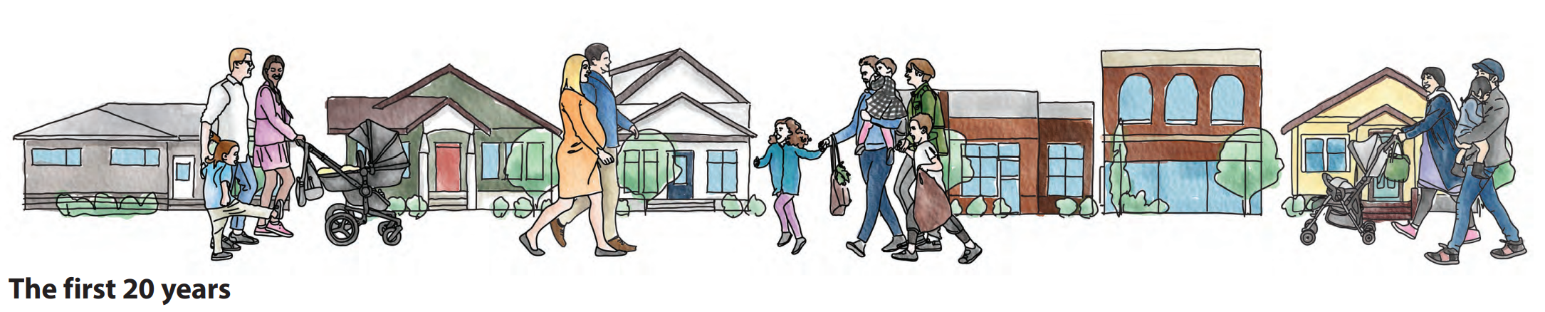
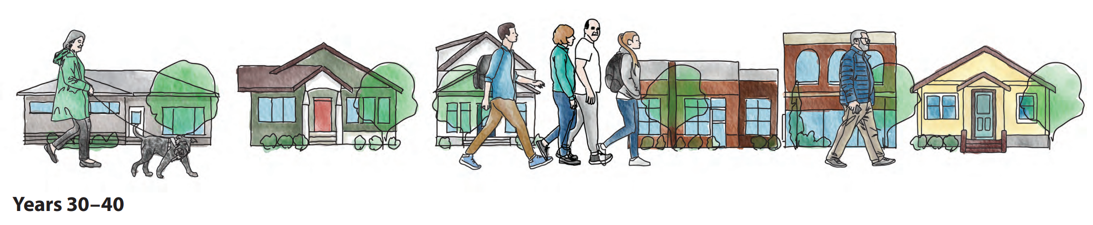
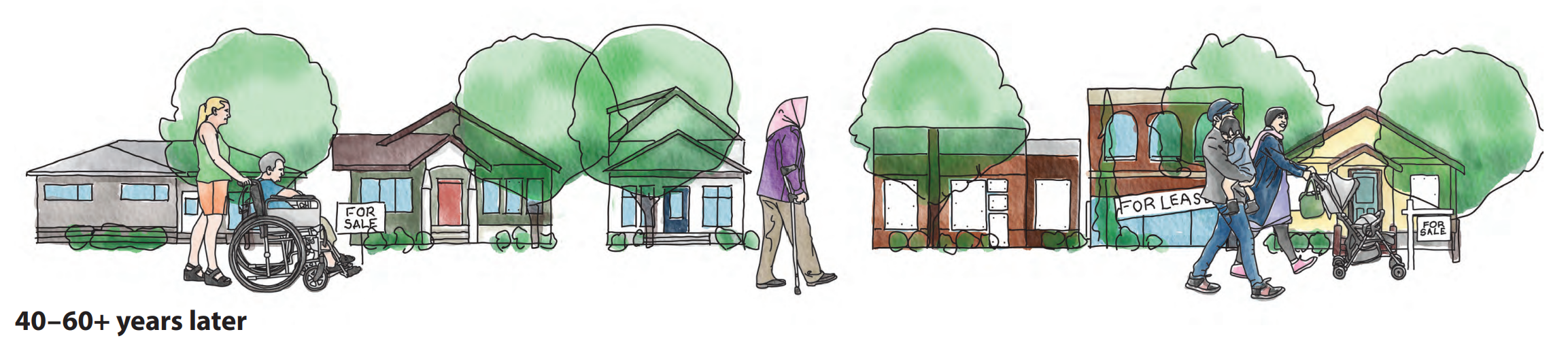
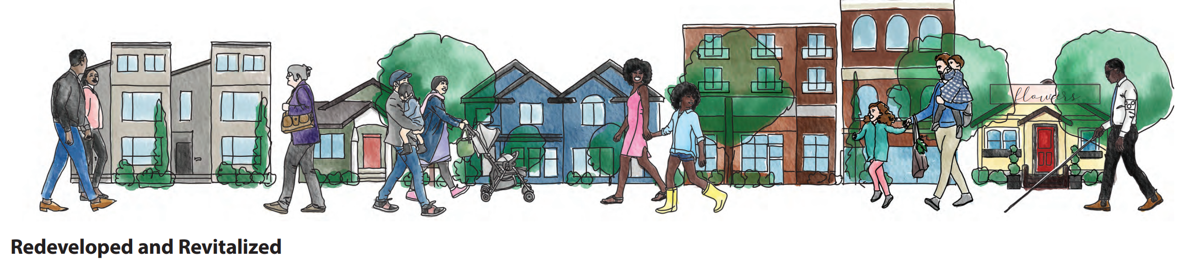
Life Cycle of a Community
Redevelopment is a natural part of a community’s life cycle, which often begins when communities reach a certain age and homes, buildings and amenities need to be refreshed and revitalized or renewed and replaced.
Let’s Talk About Small-Scale Homes
On September 16, 2023, Council approved Home is Here – The City of Calgary’s Housing Strategy. Part of that strategy directed Administration to bring forward land use changes that would make R-CG the base residential district across the city.
What would change if R-CG were the base residential district across the city?
If Council approves these changes, it would then be legal to apply to build a variety of small-scale homes such as single detached, semi detached, rowhouses and townhouses on any residential lot in the city. While this would remove the land use redesignation / rezoning requirement for these homes, this does not change the existing development permit review process.
What are the next steps?
Administration is currently working on providing more information and opportunities for you to share your input. All property owners who may be affected by these changes will be directly notified by The City. We currently expect that the public hearing, which will include the opportunity to submit comments and speak to Council, will take place in spring (Q2) 2024. The date will be confirmed as soon as possible. For more information on Home is Here – The City of Calgary’s Housing Strategy, go to calgary.ca/housingstrategy


TOPIC 1: Provide Your Input!
TOPIC 2: Draft Maps
What We've Heard So Far
In the last phase of engagement, we started the conversation about where buildings of four storeys or greater could potentially be added into the area. Themes explored were: around transit stations, along Main Streets and corridors, as well as at key intersections.
We received lots of great feedback. For example, we heard:
- Focus development along Main Streets and high-activity streets.
- Enable more growth around the Lions Park Station.
- Provide transitions from corridors and activity centres, where the most growth is anticipated to happen, into lower-density residential areas.
You will see that we’ve made changes or confirmed we were on the right track in response to the feedback received in Phase 2 (see maps below). For example:
- Emphasized moderate to large scale development along key corridors such as 10 St. N.W., 14 St. N.W., Kensington Rd. N.W.,19 St. N.W. and 5/6 Ave. N.W.
- Included more areas for growth around the Lions Park Station.
- Provided scale transitions of four-storey development between corridors and lower-density areas.
See how these examples have been reflected by reviewing the maps below.
Review the full Phase 2 What We Heard Report and/or the Phase 2 What We Did Report to learn more.

Growth and Development Will Happen With or Without a Local Area Plan
All property/landowners have the right to propose changes to their land. New homes and buildings are proposed in response to people’s changing wants and needs. When development is proposed, a local area plan provides direction on what makes sense where and provides property/landowners, residents, City Planners and Council with direction to inform development decisions.
A local area plan aims to balance the need to provide flexibility for people looking to make changes, certainty for existing residents and direction when development proposals are brought forward.
Your feedback on the draft maps on the inside fold will help guide where growth and development could fit best in the Riley Communities over the next 30 years.

Draft Local Area Plan Maps
There are two maps in a local area plan that outline what type and scale/height of development makes sense where:
Map 1: Draft Urban Form Map
The Draft Urban Form Map shows the types of uses proposed for different areas. These can include primarily commercial/business areas, primarily residential areas and parks and open space.
Map 2: Draft Building Scale Map
The Draft Building Scale Map shows the allowable building height and size for different areas. The various scale categories contain policies that outline both building heights and also other design considerations such as step backs (where higher floors are set back from lower floors).
Take a look at the draft maps below. These draft maps have not been finalized and we are looking for your input.


View the Draft Urban Form Map and Draft Building Scale Map in PDF format if you'd prefer.
The Urban Form legend and Building Scale legend (which includes descriptions of each category) is also available in PDF format.
These draft maps can also be found in the revised Draft Chapter 2 local area plan content, along with supporting draft development direction (policies).
TOPIC 2: Provide Your Input!
TOPIC 3: Community Improvements
Core Values and Community Improvements
Community improvements are changes to amenities, public spaces, services, parks and open spaces, and public facilities that support neighbourhoods across the Riley Communities. They are not site-specific as they are meant to benefit the whole Plan area, provide benefits to more than one resident and are intended to be actionable. Examples could include projects such as:
- upgrades to parks
- wider sidewalks
- new bikeway/pathway connections
- increased tree canopy
Community improvements are identified as investment priorities in a local area plan, but do not have associated funding and have no timeline attached to implementation. As investment priorities, they may be implemented by various groups including The City, developers, communities, etc. in connection with redevelopment if and when funding becomes available.
Let's chat about the kinds of improvements and changes will help support new growth and improve neighbourhood amenities in these communities.
To help frame this discussion, we will refer back to our core values.
| CORE VALUES | COMMUNITY IMPROVEMENTS |
|
|
| |
| |
| |
|


Additional investment priority details can be found in draft Chapter 3 of the local area plan.
TOPIC 3: Provide Your Input!
ADDITIONAL FEEDBACK: Draft Chapters
The draft chapter 1, chapter 2 and chapter 3 of the Riley Communities Local Area Plan are available for review.
Please click on the links to review the draft chapters and give your feedback in the question below.
- Draft Chapter 1 - Riley Communities Local Area Plan: Information about the history of the area, the area as it exists today, and the future vision and core values to help guide growth and change are included in draft Chapter 1.
- Draft Chapter 2 - Riley Communities Local Area Plan: A refined draft of Chapter 2 has been created for review.
- Draft Chapter 3 - Riley Communities Local Area Plan: An initial draft of Chapter 3 has been created for review.
Chapter 1 draft content was created and refined through engagement in Phase 1: ENVISION. Initial Chapter 2 draft content was created based on engagement in Phase 1: ENVISION and was further refined based on feedback provided through Phase 2: EXPLORE.
A refined version of Chapter 2 is now available above along with Draft Chapter 3, which will also be refined.
DRAFT Local Area Plan content
-
 DRAFT Chapter 1 Riley Communities Local Area Plan contentPDF (11.07 MB)
Information about the history of the area, the area as it exists today, and the future vision and core values to help guide growth and change are included in draft Chapter 1.
Chapter 1 draft content was created and refined through engagement in Phase 1: ENVISION.
-
DRAFT Chapter 2 Riley Communities Local Area Plan contentPDF (1.82 MB)
The Draft Urban Form & Building Scale Maps, as well as supporting development direction (policies) are included in Chapter 2.
Chapter 2 draft content was created based on engagement in Phase 1: ENVISION and Phase 2: EXPLORE. Chapter 2 content will be further refined based on input collected in Phase 3: REFINE (Spring-Summer 2022).
-
DRAFT Chapter 3 Riley CommunitiesPDF (462.12 KB)
Priorities for investment, that support growth and change in the area, are outlined in Chapter 3.
Chapter 3 draft content was created based on engagement through all phases of engagement and will be further refined based on input collected through Phase 3: REFINE (Spring-Summer 2022).


