ABOUT THE PROJECT
The City recently completed the process of drafting an Area Structure Plan (ASP) for the Ricardo Ranch community. The Ricardo Ranch Area Structure Plan was approved by Council in November 2019.
The Ricardo Ranch ASP provides a vision for the future development of 570 hectares (1,410 acres) of land located within the southeast sector of the city. The plan area is bounded by the undeveloped community of Rangeview to the north, by unplanned and undeveloped lands to the east, by the Bow River to the south, and by the community of Cranston to the west. The plan area is a joint planning area between The City and the Municipal District of Foothills, and followed the processes outlined in the Intermunicipal Development Plan for the Municipal District of Foothills and The City of Calgary.
The northern portion of the Ricardo Ranch ASP area is a plain, whereas the south portion of Ricardo Ranch is a low-lying native grassland area adjacent to the Bow River to the south. An escarpment separates the north and south portions of the Ricardo Ranch ASP area. A ravine system provides a unique natural amenity along the south portion of the plan area.
Ricardo Ranch was the name of the ranch in this area owned by Senator Patrick Burns, businessperson and co-founder of the Calgary Stampede. The ranch was named for its former owner, William Crawley Ricardo.
What is an Area Structure Plan (ASP)?
An ASP is a long-term planning document that sets out a vision for a community and puts in place policies and guidelines that work towards achieving that vision. The purpose of an ASP is to:
- Refine and implement The City’s broad planning objectives and policies of the Municipal Development Plan and other policies by promoting logical, compatible and sustainable development.
- Guide and direct the specific land use, subdivision and development decisions that collectively determine the form that the plan area will take. These development decisions include the provision of land uses, essential services and facilities, transportation systems, population, jobs and densities, and the sequence of development.
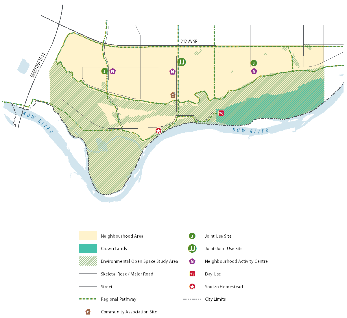
MAP OF PLAN AREA

Your Input
YOUR INPUT
In June 2018, The City was collecting input into the proposed land use concept ideas and future vision for the Ricardo Ranch area. This feedback opportunity is now closed.
A What We Heard Report summarizing the comments received can be found here.
To stay connected to the project sign up for email updates.
June 2018 Engagement
PROPOSED LAND USE CONCEPTS
These maps outline the general allowable land uses in a specific area. Click on each image to expand to a larger version and inform your answers to the below.
Land Use Concept #1
Land Use Concept #2

Land Use Concept #3

Land Use Concept Element Definitions

UNIQUE FEATURES OF THE PROPOSED CONCEPTS
Land use concept 1
- Neighbourhood Activity Centres located along proposed central spine street.
- Neighbourhood Activity Centres adjacent to Joint Use Sites.
- Day Use area proposed within Crown Lands.
- Community Association site located central to the community at the edge of the
- escarpment. Not adjacent to Neighbourhood Activity Centre.
- One access road into potentially developable lands in the lower bench lands.
- Escarpment road proposed in western portion of plan area only.
Land use concept 2
- Neighbourhood Activity Centres located at edge of escarpment.
- Neighbourhood Activity Centres not adjacent to Joint Use Sites.
- No day use area proposed
- Community Association site located central to the community at the edge of the escarpment, adjacent to Neighbourhood Activity Centre.
- Two access roads into potentially developable lands in the lower bench lands.
- No escarpment roads proposed.
- Community Retail Centre located near Neighbourhood Activity Centre.
Land use concept 3
- Neighbourhood Activity Centres located at along central spine road and along escarpment.
- Only 1 Neighbourhood Activity Centre adjacent to Joint Use Sites.
- Day Use area proposed at confluence of Bow River and Oxbow.
- Community Association site at edge of escarpment, adjacent to Neighbourhood Activity Centre.
- No access roads into potentially developable lands in the lower bench lands.
- Escarpment road proposed along majority of escarpment.
- Gateway area proposed (high quality, street-oriented corridor).
Online Comment Form
STATUS
In June 2018, The City was collected input to inform the Ricardo Ranch Area Structure Plan (ASP), this feedback opportunity is now closed.
- Council gave first reading to the proposed Ricardo Ranch Area Structure Plan (ASP) on July 29, 2019.
- The ASP was forwarded onto the Calgary Metropolitan Region Board for review and was approved in October 2019.
- The ASP was presented to City Council and approved in November 2019.


