CONSTRUCTION UPDATE – Work starting mid-July 2023
Thanks to
everyone who provided input for this project. Using the chosen design concept, we will be starting construction in mid-July 2023. We expect to be completed by
December 2023. Work
will be completed in sections along the corridor. Access for pedestrians will
be maintained throughout construction.
As part of the project, The City will be completing the following work:
- Building a protected on-street wheeling lanelane (separated from vehicular traffic) on the north side of McDougall Road from 6 Street to 12 Street N.E.,
- Providing a raised wheeling lane on the south side of McDougall Road from 6 Street to 12 Street.
- Replacing sidewalks on the southside of McDougall Road between 9 Street and 12 Street N.E.
- Milling and paving McDougall Road from 6 Street to 12 Street N.E.
- Narrowing the pedestrian crossings at the following locations to make it safer for people to cross the road:
- Centre Avenue and 9 Street N.E.
- St. Matthew Square and 9 Street N.E. (This work is being completed based on budget availability)
Parking changes on McDougall Road
We will need to remove parking on the north side of the corridor from 6 Street N.E. to 12 street N.E. It will not impact the angled parking on the north side of McDougall Road between 7 Street and 7A Street or the parking bay between 9 Street and 9A Street.
Most of the on-street parking on the south side of McDougall Road will remain. During construction, temporary restrictions will be in place to on-street parking on the south side of the corridor.
New Project website for construction updates
For more information on what to expect during construction and construction timelines, please see the new project website at Calgary.ca/Bridgeland-imporvements.ca.
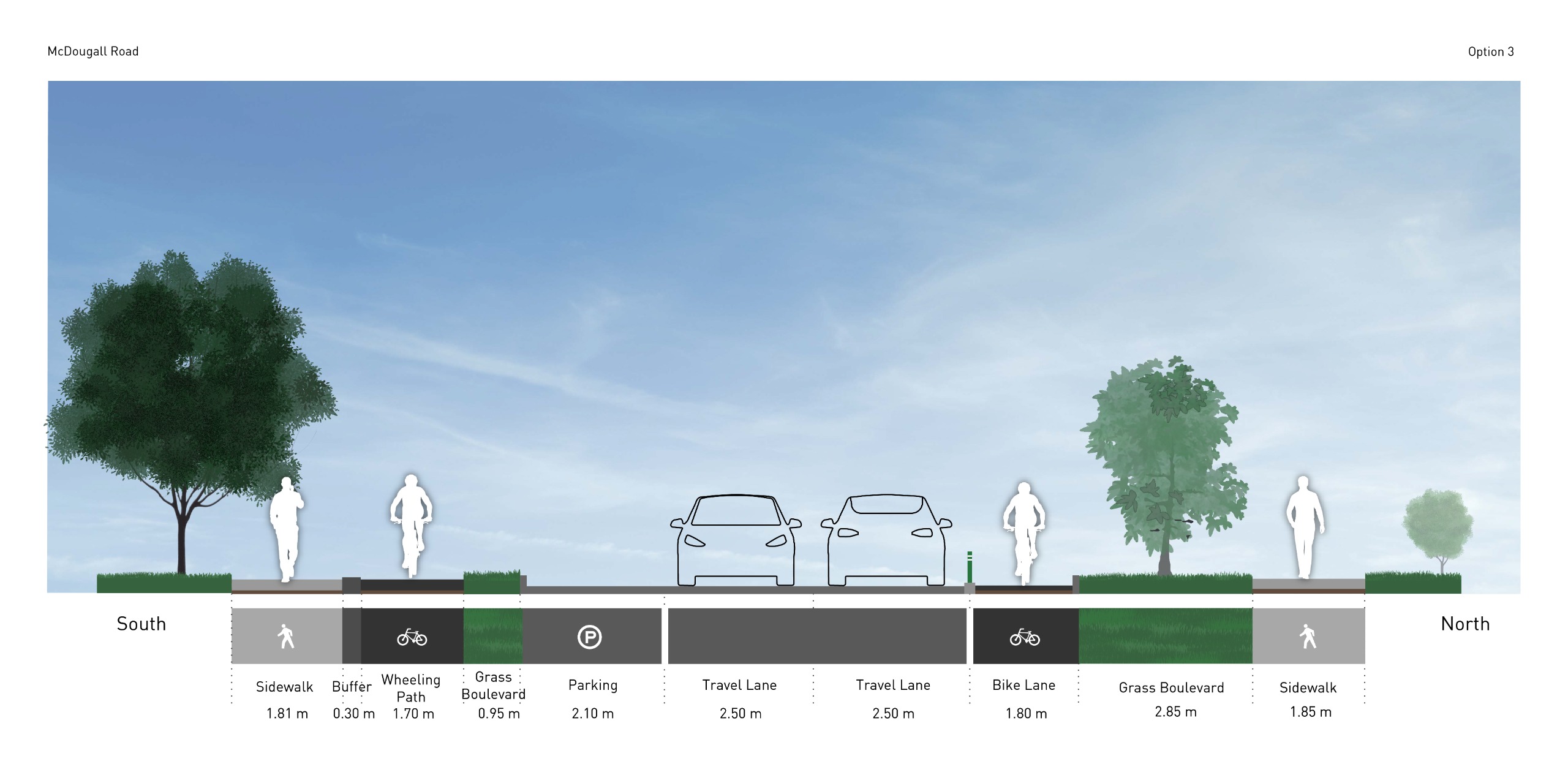
PROJECT UPDATE - Design Concept Chosen
Thank you to everyone who provided feedback during Phase 1 and 2 for this project. Based on the public input received that included maintaining green space while still improving connections for people walking and wheeling in conjunction with technical analysis and cost considerations, we have chosen Concept 3: Protected Wheeling Lane and Wheeling Path.
This concept is showed in the photo below. It consists of building a protected on-street wheeling lane on the north side of McDougall Road from 6 Street to 12 Street N.E., separated from vehicular traffic by a precast concrete curb with delineators, and providing a raised wheeling lane on the south side of McDougall Road from 6 Street to 12 Street. This design allows us to preserve green space on both sides of this corridor.
Chosen concept design
If anyone has questions about this decision for this project, please feel free to attend our upcoming public information session or email bridgeland-improvements@calgary.ca
ABOUT THE PROJECT
The communities of Bridgeland-Riverside have been experiencing population growth from a number of new multi-storey residential and commercial developments over the past ten years. Investing in improving infrastructure provides capacity to support growth and change in these communities. Through past public engagement in Bridgeland, including the 1 Avenue N.E. Streetscape Master Plan Project, we've heard some comments on issues and opportunities relating to mobility in the community.
In this project, we’re exploring improvements to walking and wheeling (bike, scooter, skateboard) connections around the Bridgeland LRT Station, along 9 Street N.E. and McDougall Road so that people have better access to destinations within the community and to the LRT station.

PROJECT FUNDING
This project is part of the Established Area Growth and Change Strategy (EAGCS). EAGCS is a program that provides funding to support short-term (1-3 years) public realm improvement projects in established communities where growth and change are happening. The Strategy connects planning, financial and investment decisions to provide the assistance that established communities need to support growth that is currently taking place so they can be vibrant and successful for decades to come.
City Council created the Established Area Investment Fund to dedicate funding for community improvements in established areas experiencing growth and change. The public realm improvements are intended to enhance mobility and the public areas within a community for current and future residents.
In 2020, Council approved the list of projects to undergo engagement, design and construction. This project was one of the projects on that approved list and has been allocated limited funds to make improvements to mobility and public spaces in the community. Based on the technical analysis and public feedback, a short list of recommended improvements will be prioritized to fit within the allocated budget. Construction of these improvements is expected to begin in 2023.
PROJECT INPUT
Based on the feedback received in the previous round of engagement, there was support to further improve the proposed active mode facilities on McDougall Road and explore options that reallocate the road right of way. The feedback also indicated that maintaining parking isn’t as important as improving accommodations for pedestrians and wheeling users and maintaining green space.

In response to the feedback, the project team has developed three (3) revised concepts for McDougall Road that maintain more of the green space by removing some parking along the corridor. We are seeking public feedback on the revised concepts.
Concept 1
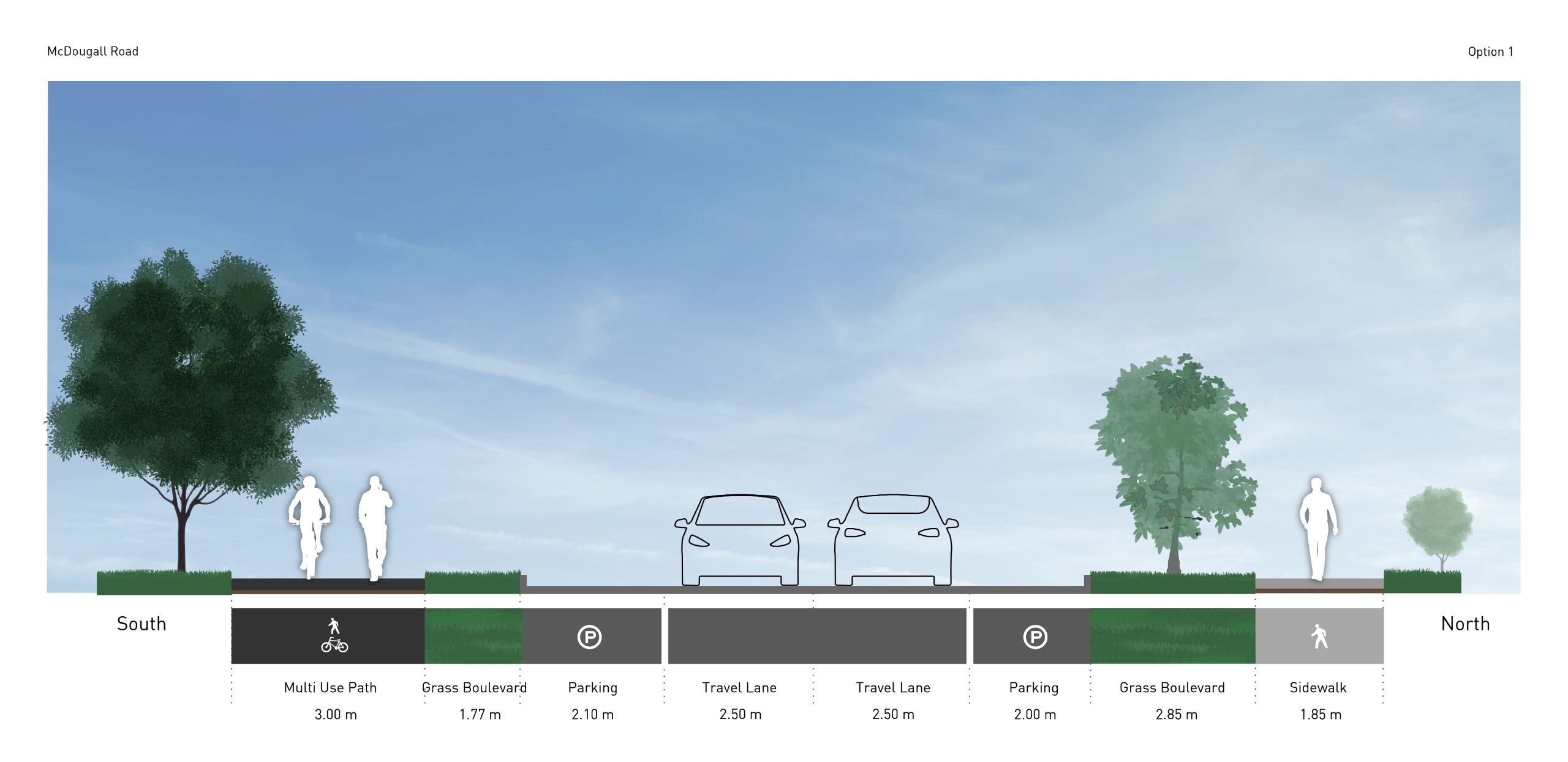
Concept 1 cross section
Please review the concept plan for this option here, and read the description below and answer the questions below.
Concept 1: Multi-Use Pathway on South Side
This concept is the same as what was presented in Phase 1. The sidewalk on the South side of McDougall Road would be replaced with a 3.0m wide (bi-directional) multi-use pathway. The North side would remain as is.
Benefits
- Appropriate for all ages and abilities.
- No changes to existing roadway.
- Maintains the majority of existing on-street parking (may be some parking reduction due to intersection improvements).
- Provides good connections to existing/proposed walking and wheeling facilities on 9 Street N.E. and 12 Street N.E.
- Reduces risk of bicycle / vehicle conflicts along the corridor.
- Maintains the existing landscaped boulevard on the north side.
- Lowest cost option.
Trade-Offs
- Increased risk of wheeling users / pedestrian conflicts on the south side along the pathway and at intersections with residential walkways.
- Risk of bicycle / vehicle conflicts on south legs of intersections.
- Potential throw-away costs with replacing/modifying existing sidewalk.
- Providing additional trees within the south grass boulevard is likely not feasible due to narrow width and presence of underground utilities.
Concept 2

Concept 2 cross section
Please review the concept plan for this option here, read the descriptions below and answer the questions below.
Concept 2: Protected Wheeling Paths on Both Sides (Uni-Directional)
This concept was presented in Phase 1 and involves replacing the existing grass boulevards on each side with wheeling paths. The wheeling paths would be located off the roadway and adjacent to the sidewalk, with a buffer space provided between the wheeling path and sidewalk to reduce the risk of conflicts between those modes of travel. This option has been updated since it was last presented to replace some existing parking space with landscaping and/or trees, where possible.
Benefits
- Appropriate for all ages and abilities
- Accommodates wheeling users on the proper (right-hand) side of the road relative to the direction of travel.
- Opportunity to increase existing sidewalk widths in some locations.
- Reduces risk of bicycle / vehicle conflicts along the corridor.
- Reduces risk of bicycle / pedestrian conflicts along the corridor by providing separate facilities.
- Replacing some of the existing parking with landscaped islands compensates for some (but not all) of the landscaping lost to accommodate the pathways.
- Provides good connections to existing/proposed walking and wheeling facilities on 9 Street N.E. and 12 Street N.E.
Trade-offs
- Some risk of bicycle / vehicle conflicts at intersections.
- Risk of conflicts between cyclists and pedestrians at intersections. Close proximity of pathways and sidewalks could create challenges for those with vision or mobility challenges.
- Existing overhead utility poles are potential hazards for wheeling users.
- Significant reduction to existing grass boulevards.
- Landscaped islands will create challenges for snow removal and street sweeping.
- Risk that proposed landscaping/trees will not survive due to close proximity to roadway and underground utilities.
- Westbound cyclists will need to travel on-street between 7 Street and 7A Street due to angle parking.
- Highest cost concept.
- Approximately 1/3 reduction in the overall number of on-street parking spaces along the corridor. No parking on north side of road east of 9 Street N.E.
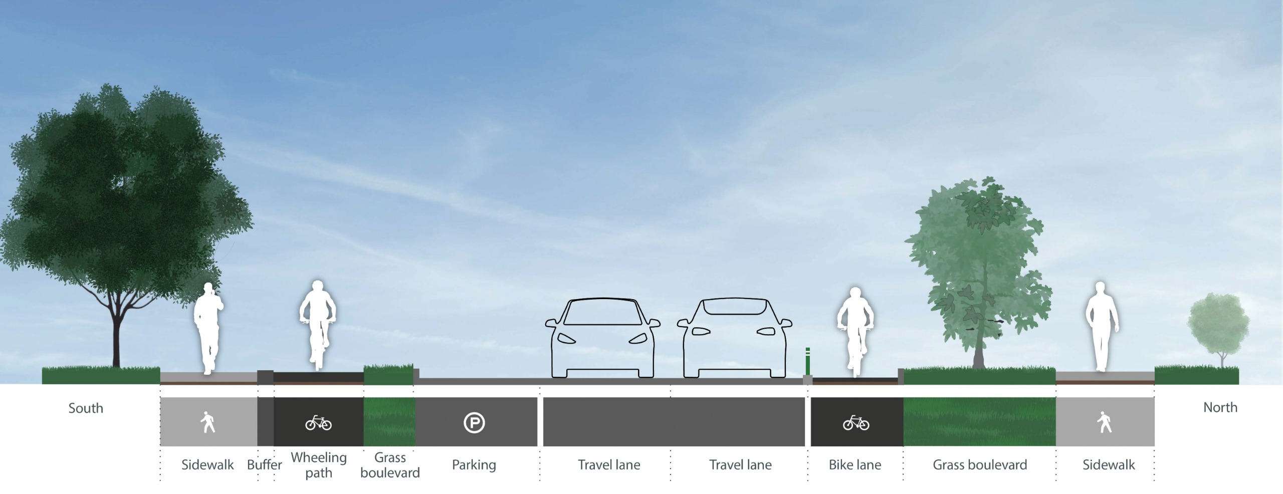
Concept 3
Concept 3 cross section
Please review the concept plan for this option here, and read the description below and answer the questions below.
Concept 3: Protected Wheeling Lane and Wheeling Path
This concept is similar to concept 2, but with the wheeling path on the North side of the road being replaced with an on-street wheeling lane to preserve existing landscaping. The on street protected wheeling lane would require the removal of parking on the North side for the entire length of the corridor.
Benefits
- Appropriate for all ages and abilities
- Accommodates wheeling users on the proper (right-hand) side of the road relative to the direction of travel.
- Reduces risk of bicycle / vehicle conflicts along the corridor.
- Reduces risk of bicycle / pedestrian conflicts along the corridor by providing separate facilities.
- The north grass boulevard is not impacted by the design.
- Reduced risk of pedestrian / bicycle conflicts on north side of intersections.
- Less construction required on north side (compared to concept 2) so lower cost and less disruption to property owners.
- Better separation between overhead utility poles and cyclists on north side of the road.
- Provides good connections to existing/proposed walking and wheeling facilities on 9 Street N.E. and 12 Street N.E.
Trade-offs
- Risk of bicycle / vehicle conflicts at intersections.
- Risk of conflicts between cyclists and pedestrians on south side of intersections.
- Landscaped islands will create challenges for snow removal and street sweeping.
- Risk that proposed trees will not survive due to close proximity to roadway and under ground utilities.
- Westbound cyclists will need to travel on-street between 7 Street and 7A Street due to angle parking.
- Approximately ½ reduction in the overall number of on-street parking spaces along the corridor. No parking accommodated on north side of the road.
McDougall Road & 8 Street Intersection

Existing conditions
The intersection of McDougall Road and 8 Street N.E. is currently a three-leg intersection. The intersection configuration is atypical due to the curved alignment on the East leg and the prohibited westbound movement on the West leg. The atypical design could be confusing for all users, which increases the risk of collisions. There have also been reports that the prohibited Westbound movements still occur on a regular basis (both intentionally and unintentionally).
This intersection creates challenges for all three corridor concepts as it is difficult to prioritize pedestrian and wheeling user movements along McDougall Road when it is only stop controlled in the eastbound direction.
In order to improve the mobility of pedestrians and cyclists along McDougall Road and increase motorist safety, the intersection needs to be realigned such that McDougall Road has a straight alignment and northbound 8 Street N.E. is stop controlled at the intersection. This would mean that the westbound movements will no longer be prohibited for this segment of McDougall Road.
The trade-off for this configuration is that it may result in some Westbound cut through traffic due to motorists trying to avoid a queue on westbound Memorial Drive. The proposed concepts for McDougall Road will have some traffic calming effects along the corridor, and additional traffic calming measures could be explored to discourage its use as a bypass of Memorial Drive.
NEXT STEPS
At the conclusion of this round of engagement, the following next steps will be taken:
- Construction of the recommended improvements will begin in mid-July 2023.
For more information on what to expect during construction and construction timelines, please see the new project website at Calgary.ca/Bridgeland-imporvements.ca.


